Wikimedi'Òc
Modes d'emploi

Cet album fait partie des albums
Cet album photos contient les sous-albums suivants :


Kärtchen zur Schlacht bei Solferino (24.06.1859).jpg - ¡0-8-15!

1885 GT text.jpg - SPUI~commonswiki

1885 NYCRR.jpg - SPUI~commonswiki

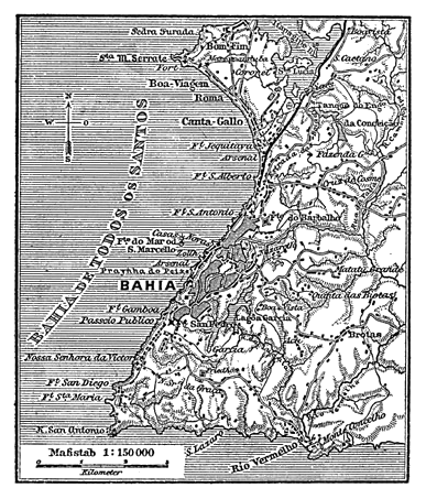
Meyers b1 s0999a.jpg - Mapmarks

Bremen Meyer 1885.png - Ulamm

PSM V26 D162 Standard railway time vs greenwich mean time.jpg - Ineuw

Deutsche kolonien 1885.jpg - File Upload Bot (Magnus Manske)

NSW Telegraph & Mail Routes-Oct 1885.jpg - Geez-oz

Plan de Rennes (1885).jpg - Denniss

Saône Tournus à Lyon 1885.jpg - Rexcornot

Itinéraire Victor Giraud.jpg - FabBec

Region of queenst. cc.JPG - Lysippos

Geologische Karte der Stadt Berlin, 1885.jpg - Alexrk2

NW Australia 1885.jpg - Geagea

Meyers b3 s0795 Karte-von-Capri.png - Cmdrjameson

1885 birds-eye map of Ludlow, Vermont.jpg - Pi.1415926535

Karte Eissen.png - Cmdrjameson

Tranvias1885.svg - Patricio.lorente

(1885) Ethnographische Karte, das Gebiet der TLINKIT.jpg - Metilsteiner

Meyers b4 s0655 b1.png - Mapmarks

Meyers b1 s0115 b1.png - Mapmarks

Meyers b2 s0139 b1.png - Mapmarks

Meyers b2 s0141 b1.png - Mapmarks
Meyers b2 s0261 b1.png - Mapmarks

Meyers b2 s0319 b1.png - Mapmarks

Meyers b2 s0642 b1.png - Mapmarks

Meyers b2 s0660 b1.png - Mapmarks

Meyers b3 s0177 b1.png - Mapmarks

BAGWELL(1885) p 1.102 Ireland about 1300.jpg - Metilsteiner

BAGWELL(1885) p 1.159 Ireland about 1500.jpg - Metilsteiner

BAGWELL(1885) p 1.325 Ireland - Ecclesiastical.jpg - Metilsteiner

BAGWELL(1885) p 1.068 Ireland in 1172.jpg - Metilsteiner
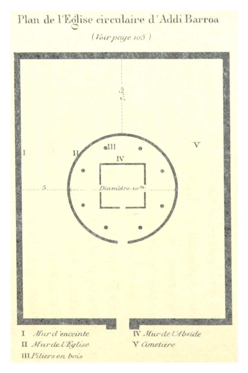
SIMON(1885) p138 Plan de l'Église de Addi-Barroa.jpg - Metilsteiner

SIMON(1885) p405 Plate 2 - Plan de l'église Médiné Allem.jpg - Metilsteiner

SIMON(1885) p403 Plate 1 - Plan général de l'église Gorghuis (Saint-Georges)..jpg - Metilsteiner

FIELD(1885) p008 THE HISTORICAL LANDSCAPES OF THE CENTRAL OTTOMAN EMPIRE.jpg - Metilsteiner

FIELD(1885) p195 TURKEY IN EUROPE, BEFORE THE WAR WITH RUSSIA.jpg - Metilsteiner
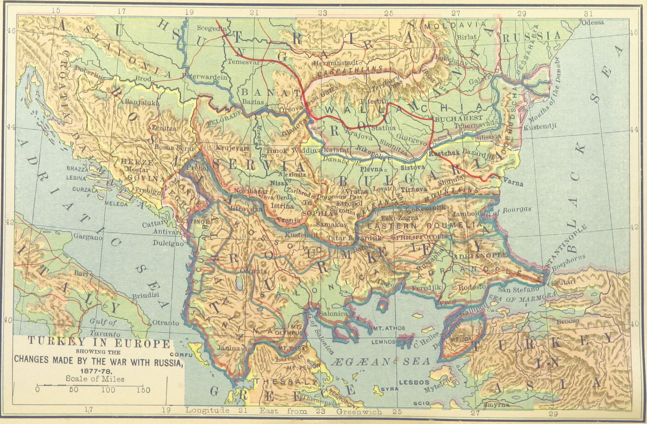
FIELD(1885) p224 TURKEY IN EUROPE, AFTER THE WAR WITH RUSSIA.jpg - Metilsteiner

GRIERSON(1885) p008 MAP.jpg - Metilsteiner

Frazier Aruba Gold Mining Co circa 1885.jpg - Ratzer

Meyers b3 s0381 b1.png - Mapmarks

Ayer station on 1885 aerial map.PNG - Pi.1415926535

A Reference handbook of the medical sciences - embracing the entire range of scientific and practical medicine and allied science (1885) (14782067334).jpg - SteinsplitterBot

Forest and stream (1885) (14594005530).jpg - Fæ

Memoirs of the Geological Survey of India. (1885) (14779625832).jpg - Fæ
A Map of the Staten Island Rapid Transit Company from 1885.png - Kew Gardens 613

Geistbeck 1885-Starnberger Königs Walchensee Tiefenkarten.jpg - Ratzer

Geistbeck 1885-Ammer Staffel Rieg Pilsen Achen Plansee Tiefenkarten.jpg - Ratzer

חיספין במפה של גוטליב שומאכר מ-1885.jpg - Hanay

Geistbeck 1885 - Königssee Tiefenkarten.png - Chumwa

Plan of Sussita by Gottlieb Schumacher 1885.jpg - Hanay

Northern Pacific Rail Road and connections (14533461260).jpg - Fæ
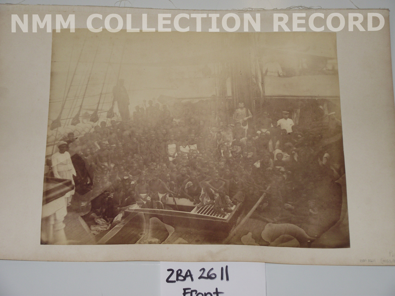
Group of slaves aboard ship RMG RT1381.jpg - Fæ

Group of slaves aboard ship RMG RT1382.jpg - Fæ

Geistbeck 1885-Spitzingsee.jpg - Pticy uleteli

Geistbeck 1885 - Schliersee.jpg - Pticy uleteli

311 of 'Viaggio di circumnavigazione della reggia corvetta “Caracciolo,” comandante C. de Amezaga, negli anni 1881-82-83-84' (11180542115).jpg - Artix Kreiger 2

Map of the siege of Vicksburg. (1864). LOC 99447420.jpg - Fæ
Map illustrative of the march of the Indian section of the Boundary Commission from Quetta to Olerat and Badkis; of the frontier as proposed and actually demarcated, and of the author's return journey LOC 76692168.tif - Fæ

Map illustrative of the march of the Indian section of the Boundary Commission from Quetta to Olerat and Badkis; of the frontier as proposed and actually demarcated, and of the author's return journey LOC 76692168.jpg - Fæ

Battle of Chattanooga, Nov. 23, 24, 25, 1863. LOC 99448453.jpg - Fæ
Plat of part of Pleasant Plains and Lemar's Outlet - being an addition to Chapins Brown's sub-division of S.P. Brown's Homestead LOC 88693029.tif - Fæ

Plat of part of Pleasant Plains and Lemar's Outlet - being an addition to Chapins Brown's sub-division of S.P. Brown's Homestead LOC 88693029.jpg - Fæ
Sanborn Fire Insurance Map from Prescott, Nevada County, Arkansas. LOC sanborn00335 001.tif - Fæ

Sanborn Fire Insurance Map from Prescott, Nevada County, Arkansas. LOC sanborn00335 001.jpg - Fæ
Map of the Mississippi at Island no. 10. Showing (corrected) line of the channel cut by the Engineer Regiment. LOC 99447230.tif - Fæ

Map of the Mississippi at Island no. 10. Showing (corrected) line of the channel cut by the Engineer Regiment. LOC 99447230.jpg - Fæ
Map of the battle field of Gaines's Mill, showing approximately the positions of infantry and artillery engaged LOC 2006626063.tif - Fæ

Map of the battle field of Gaines's Mill, showing approximately the positions of infantry and artillery engaged LOC 2006626063.jpg - Fæ

Map of the battle of Malvern Hill, showing, approximately, positions of brigades and batteries. (July 1, 1862). LOC 99439181.jpg - Fæ
Saimoppo bochi kinbōzu LOC 2008486358.tif - Fæ

Saimoppo bochi kinbōzu LOC 2008486358.jpg - Fæ
Sanborn Fire Insurance Map from Sturgis, Meade County, South Dakota. LOC sanborn08266 001.tif - Fæ

Sanborn Fire Insurance Map from Sturgis, Meade County, South Dakota. LOC sanborn08266 001.jpg - Fæ
Hokusei yori Kōzan, Sansui, Kōshō, Chōshin o hete Chūreichin ni itaru LOC 2008486711.tif - Fæ
Hokusei yori Kōzan, Sansui, Kōshō, Chōshin o hete Chūreichin ni itaru LOC 2008486711.jpg - Fæ
Region of the Seven Days' fighting (June 25-July 1, 1862). LOC 99448343.tif - Fæ

Region of the Seven Days' fighting (June 25-July 1, 1862). LOC 99448343.jpg - Fæ
Sanborn Fire Insurance Map from Berkeley Springs, Morgan County, West Virginia. LOC sanborn09389 001.tif - Fæ

Sanborn Fire Insurance Map from Berkeley Springs, Morgan County, West Virginia. LOC sanborn09389 001.jpg - Fæ

Curtice & Potts' standard map of Ramsey Co., Minnesota LOC 2012593066.jpg - Fæ

Fort Myer and vicinity LOC 89692637.jpg - Fæ
Map of the Baltimore Division; Adams Express Company. LOC 98688572.tif - Fæ

Map of the Baltimore Division; Adams Express Company. LOC 98688572.jpg - Fæ
Senkankyō yori Kōshū ni itaru ryakuzu LOC 2008486712.tif - Fæ

Senkankyō yori Kōshū ni itaru ryakuzu LOC 2008486712.jpg - Fæ
Map showing location of the "Gallego" forty thousand acres of coal and timber lands, Fayette County, W. Va. LOC 2005625162.tif - Fæ

Map showing location of the "Gallego" forty thousand acres of coal and timber lands, Fayette County, W. Va. LOC 2005625162.jpg - Fæ
Sanborn Fire Insurance Map from Sundance, Crook County, Wyoming. LOC sanborn09782 001.tif - Fæ

Sanborn Fire Insurance Map from Sundance, Crook County, Wyoming. LOC sanborn09782 001.jpg - Fæ
Sanborn Fire Insurance Map from Bellevue, Blaine County, Idaho. LOC sanborn01565 001.tif - Fæ

Sanborn Fire Insurance Map from Bellevue, Blaine County, Idaho. LOC sanborn01565 001.jpg - Fæ

General map of the battle-field of Manassas. (July 16-21, 1861) LOC 99439137.jpg - Fæ
Grand birds eye view of the Great East River Suspension Bridge. Connecting the cities of New York & Brooklyn showing also the splendid panorama of the bay and part of New York. LOC 75694811.tif - Fæ

Grand birds eye view of the Great East River Suspension Bridge. Connecting the cities of New York & Brooklyn showing also the splendid panorama of the bay and part of New York. LOC 75694811.jpg - Fæ
Sanborn Fire Insurance Map from Spearfish, Lawrence County, South Dakota. LOC sanborn08265 001.tif - Fæ

Sanborn Fire Insurance Map from Spearfish, Lawrence County, South Dakota. LOC sanborn08265 001.jpg - Fæ
The solar system. LOC 2013593146.tif - Fæ

The solar system. LOC 2013593146.jpg - Fæ

Map of Charleston and its defences LOC 99448840.jpg - Fæ
Map of Fort Myer, Va. and vicinity LOC 89692636.tif - Fæ

Map of Fort Myer, Va. and vicinity LOC 89692636.jpg - Fæ
Yellowstone National Park and north western Wyoming. LOC 97683576.tif - Fæ

Yellowstone National Park and north western Wyoming. LOC 97683576.jpg - Fæ
Da Qing er shi san sheng yu di quan tu; fu Chaoxian zhou dao yu di tu. LOC gm71005068.tif - Fæ

Da Qing er shi san sheng yu di quan tu; fu Chaoxian zhou dao yu di tu. LOC gm71005068.jpg - Fæ
Kyoryūchi yori Teihei-fu ni itaru mitorizu LOC 2008486375.tif - Fæ

Kyoryūchi yori Teihei-fu ni itaru mitorizu LOC 2008486375.jpg - Fæ
Sanborn Fire Insurance Map from Ketchum, Blaine County, Idaho. LOC sanborn01623 001.tif - Fæ

Sanborn Fire Insurance Map from Ketchum, Blaine County, Idaho. LOC sanborn01623 001.jpg - Fæ

Gerichtsbezirke von Kärnten, der Steiermark und Krain von 1885.jpg - Christian1311
Carta geologica dell’isola d’Elba. Roma, Tip. Nazionale, 1884 - 1886.jpg - Argonitros

Map of Lhasa, Tibet (Thibet) and the Himalayas in 1885 from 12 of 'The Imperial Gazetteer of India ... Second edition (revised and enlarged)' (11180098823) (cropped).jpg - Tibet Nation

Map of the proposed Nicaragua Canal from Meyers b16 s0558a (cropped).jpg - Tibet Nation

Map of the Panama Canal, Meyers b16 s0558a (cropped).jpg - Tibet Nation

EB9 Saint Helena.png - LlywelynII

1885- Claes; Ghys, Ghys, Martin, Felixarchief, 12 8841.jpg - Sam.Donvil

Chicago, Milwaukee, and St. Paul R'y - the short line between Chicago, Milwaukee, St. Paul, Minneapolis. LOC 96687300.jpg - Fæ

"JACOB DAEUFER FOUNTAIN BREWERY" on Union Street in March 1885, from- Sanborn Fire Insurance Map from Allentown, Lehigh County, Pennsylvania. LOC sanborn07494 001-2 (cropped).jpg - Tibet Nation
Carte du fleuve Rouge droite 1885 05209.jpg - Gérald Garitan

Carte du fleuve Rouge gauche 1885 05210.jpg - Gérald Garitan

Старая крепость Ведено и Укрепление Ведено штаб квартира 79-го Куринского полка 1859-1878 гг.jpg - Товболатов

Bielsko, Dolne Przedmieście, kamienica Korna i willa Sixta na mapie katastralnej (około 1885).jpg - Gaj777

Nautical Chart of the East Coast of Central America - DPLA - 36120e829aa535c4ec01428dbf18d656.jpg - DPLA bot

Cutout from Saône Tournus à Lyon 1885.jpg - Lantus

Соціальна карта ніжинського уезда 1885.jpg - Anton Kuripko

Карта грунтів ніжинського уезда 1885.jpg - Anton Kuripko

Nahum Sokolow, מפת ארץ הקדושה לס' ארץ חמדה (FL199420699 2369249).jpg - Geagea

Heinrich Kiepert, Map of routes to the Levant (FL155882612 4049679).jpg - Geagea

Übersichtskarte des Europäischen Kolonialbesitzes 01 (FL159344597 4076696).jpg - Geagea

Übersichtskarte des Europäischen Kolonialbesitzes 02 (FL159344598 4076696).jpg - Geagea

Heinrich Kiepert, Italia (FL159663164 2591084).jpg - Geagea

Modern Egypt (FL35098764 3892750).jpg - Geagea

The Gentile countries and nations of the Old Testament (FL35098794 3892755).jpg - Geagea

Palestine (FL37119248 3896481).jpg - Geagea

Map showing the missionary tours of the Apostle Paul (FL37663542 3915753).jpg - Geagea

The Holy Land in the time of Christ (FL37663573 3915702).jpg - Geagea

Palestine (FL37825676 3923398).jpg - Geagea

Nahum Sokolow, מפת ארץ הקדושה לס' ארץ חמדה (FL42167302 3930672).jpg - Geagea
Hiram H. Hardesty, Map of Jerusalem (FL45582674 3925477).jpg - Geagea

Hiram H. Hardesty, Environs of Jerusalem (FL45582675 3925504).jpg - Geagea

Western Australian Legislative Council electoral districts, 1885.png - ITBF