Wikimedi'Òc
Modes d'emploi

Cet album fait partie des albums
Cet album photos contient les sous-albums suivants :


Treaty of Lochaber.jpg - Muhranoff

Map of part of Augusta County, Colony of Virginia, 1755-1760 LOC 99446928.jpg - Fæ

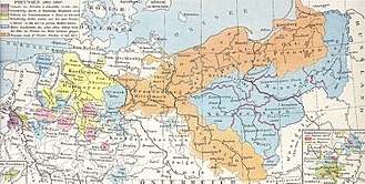
Grossfuerstentum Moskau.jpg - ¡0-8-15!
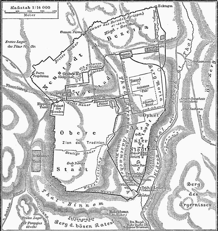
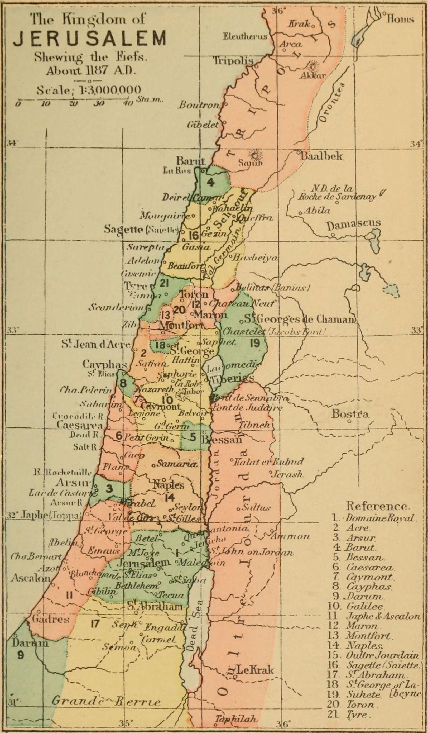
Historische Karte von Jerusalem MK1888.png - ¡0-8-15!

Situationsplan von Karthago.jpg - ¡0-8-15!

CanaanMap.jpg - ImageObserver

SouthEast Europe 1878.jpg - PRODUCER

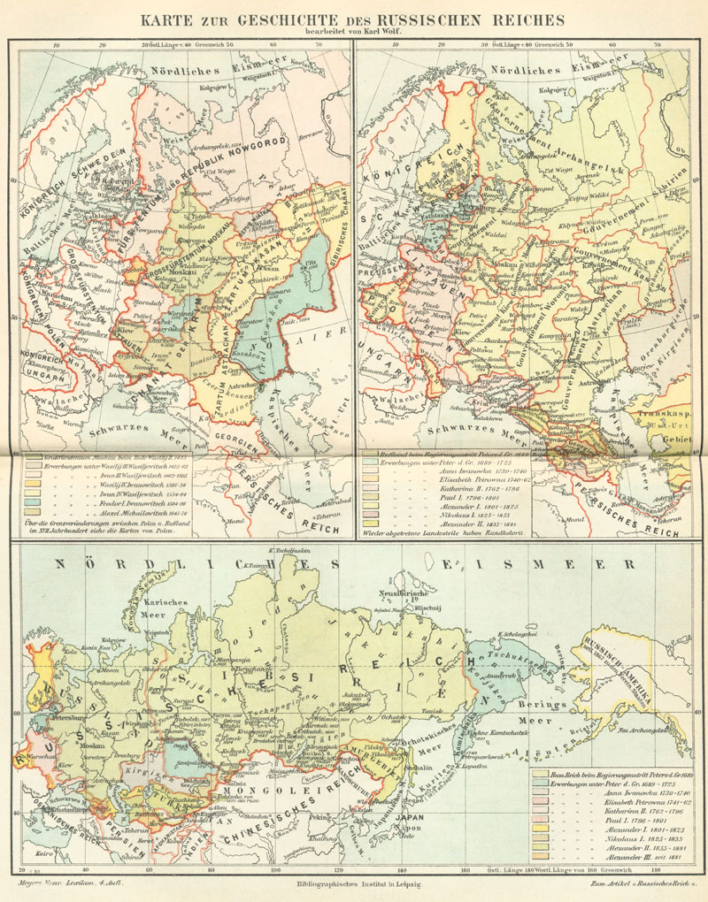
Meyers b13 s0173a.jpg - Mapmarks

Meyers b13 s0363a.jpg - Mapmarks

Maps of the Ancient World.png - Bastique

Kingdoms of Lydia, Media, Cilicia, and later Babylonia.png - Editor at Large
Meyers b14 s0080a.jpg - Mapmarks
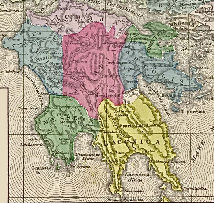
Ancient peloponnese.jpg - Frokor

Meyers b15 s0924a.jpg - Red Rooster
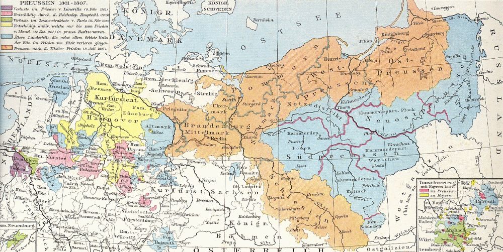
Preussen-1806.jpg - Olessi

Frankrike och england 1180.jpg - Hedning~commonswiki
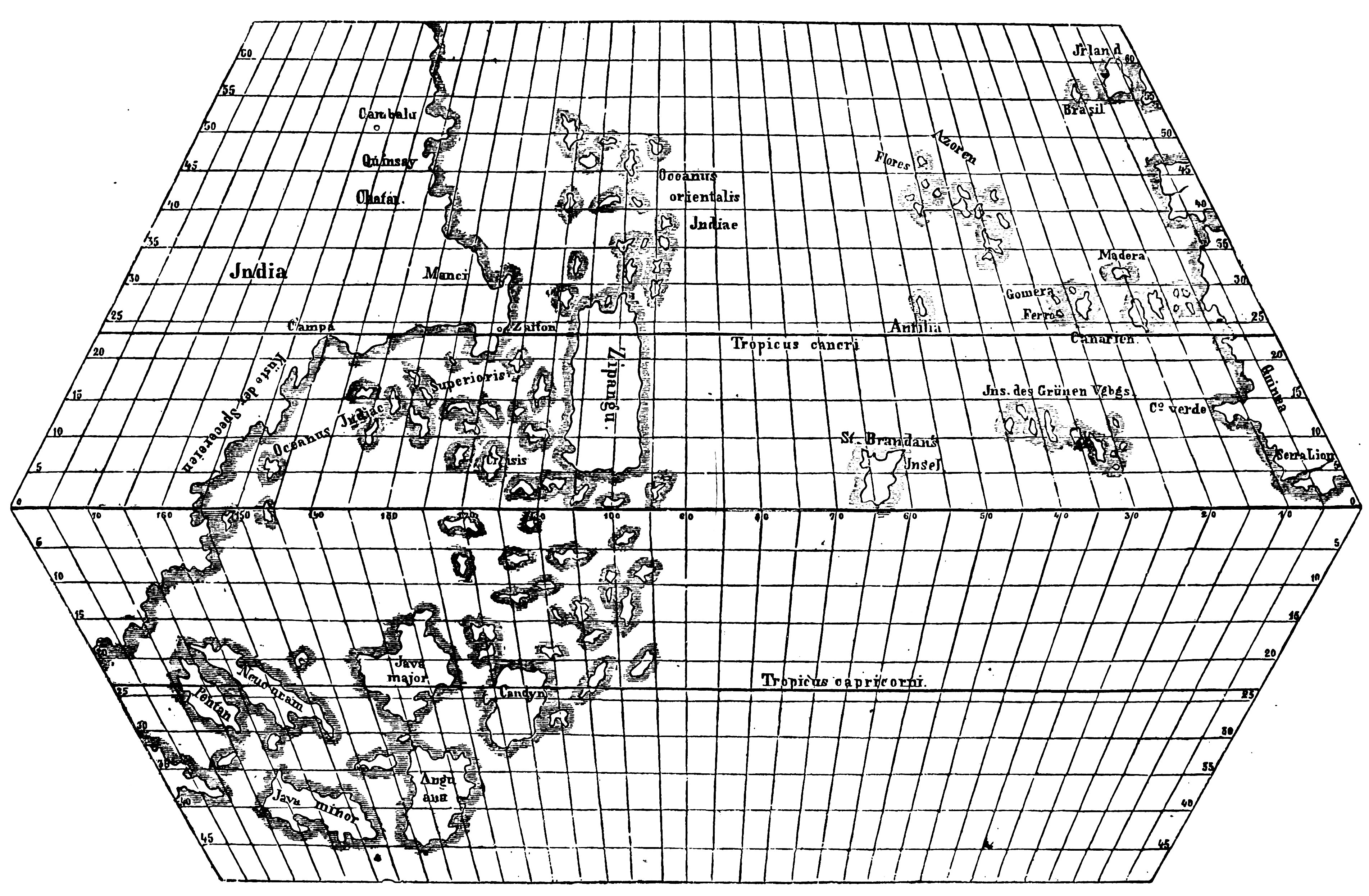
Toscanelli map.jpg - Bness2
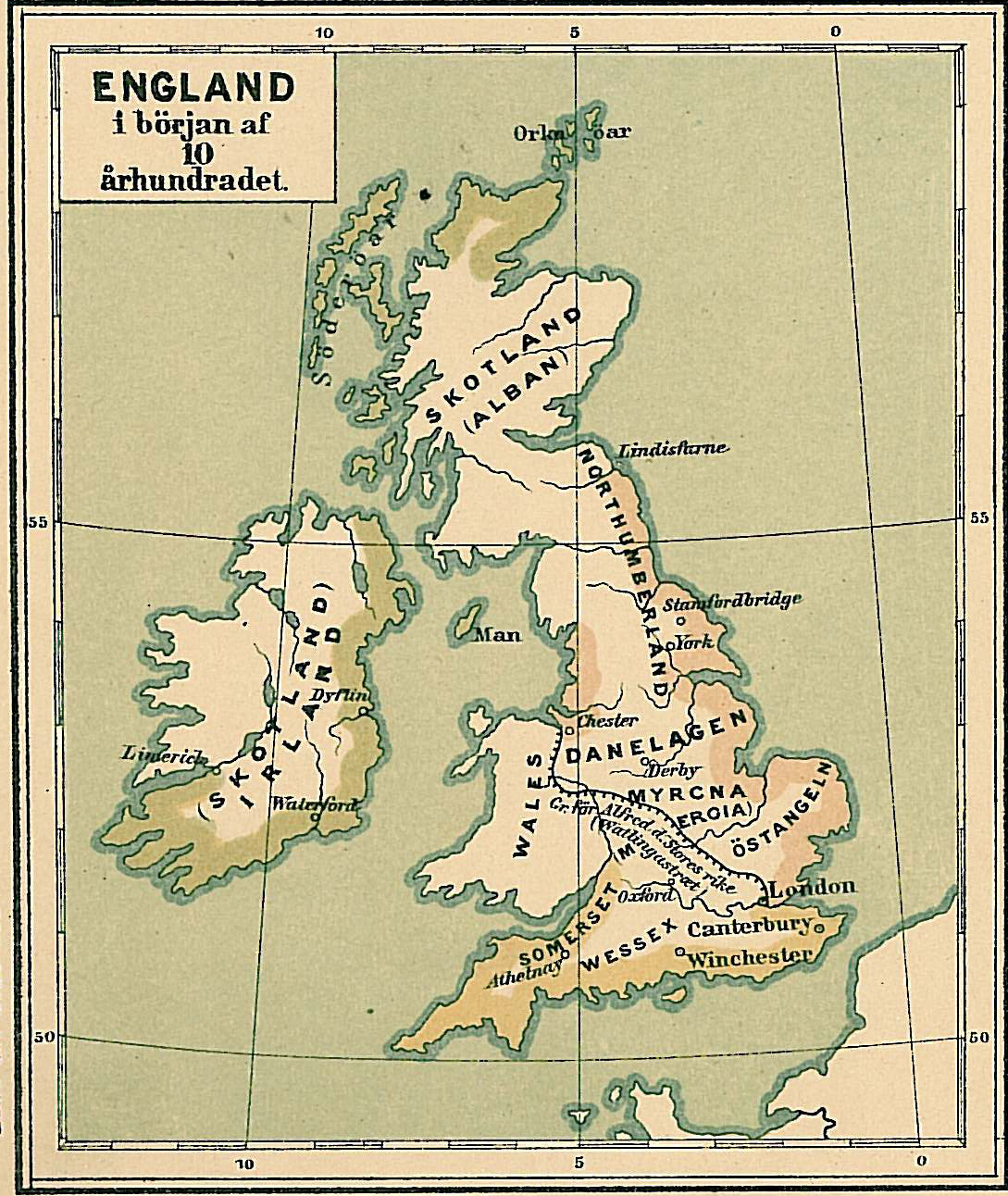
England i början av 900-talet.jpg - Hedning~commonswiki

Iraq area, 586 B.C..png - Chuck Marean
Mesopotamia & nearby, 7th century B.C..png - Chuck Marean
Atlantic Ocean, Toscanelli, 1474.jpg - Soerfm

Asia Minor Map, Classical Atlas, 1886, Keith Johnston.jpg - Jssfrk

Assyria 1130-606 BC.png - Chuck Marean

The divided kingdom.jpg - Avicennasis

Balkans in 1350 according to Gustav Droysen from 19th century.jpg - BosnaSRB RS
Boston 1772.png - Matanya

Alary, Jurien de La Gravière. Carte de la mer Noire (Pont Euxin) pour servir à l'histoire de la marine des Romains. 1884.jpg - Geagea
Droysens-24.jpg - Maproom
Plan von Düsseldorf 1620.jpg - NordNordWest

Plan von Düsseldorf 1620 gedreht.jpg - NordNordWest

Plan von Düsseldorf 1620 Ausschnitt.jpg - NordNordWest

Palestine (1889 book) 03.jpg - Pineway

Palestine (1889 book) 30.jpg - Joalbertine
Palestine (1889 book) 32.jpg - Joalbertine

Palestine (1889 book) 31.jpg - Joalbertine

CanaanMap-ar.jpg - Freedom's Falcon

Image from page 230 of "A dictionary of the Bible.." (1887) (14595154277).jpg - Geagea
Meyers b4 s0884a.jpg - Mapmarks

Карта театра войны с персиянами 1827.jpg - Sabuhi from Baku

TIMAYENIS(1881) p1.208 SALAMIS.jpg - Metilsteiner

TIMAYENIS(1881) p1.235 PLATAEA.jpg - Metilsteiner
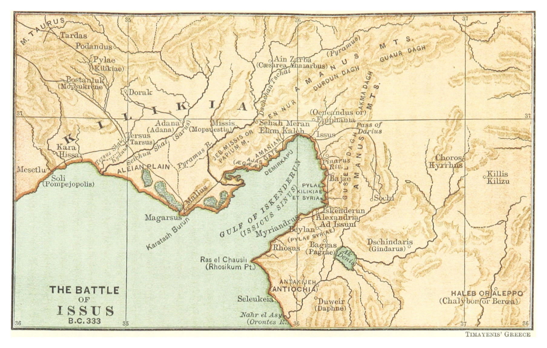
TIMAYENIS(1881) p2.125 ISSUS.jpg - Metilsteiner

TIMAYENIS(1881) p2.227 CITY OF RHODES.jpg - Metilsteiner
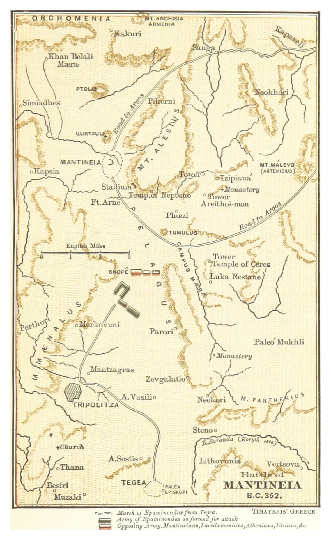
TIMAYENIS(1881) p2.047 MANTINEIA.jpg - Metilsteiner
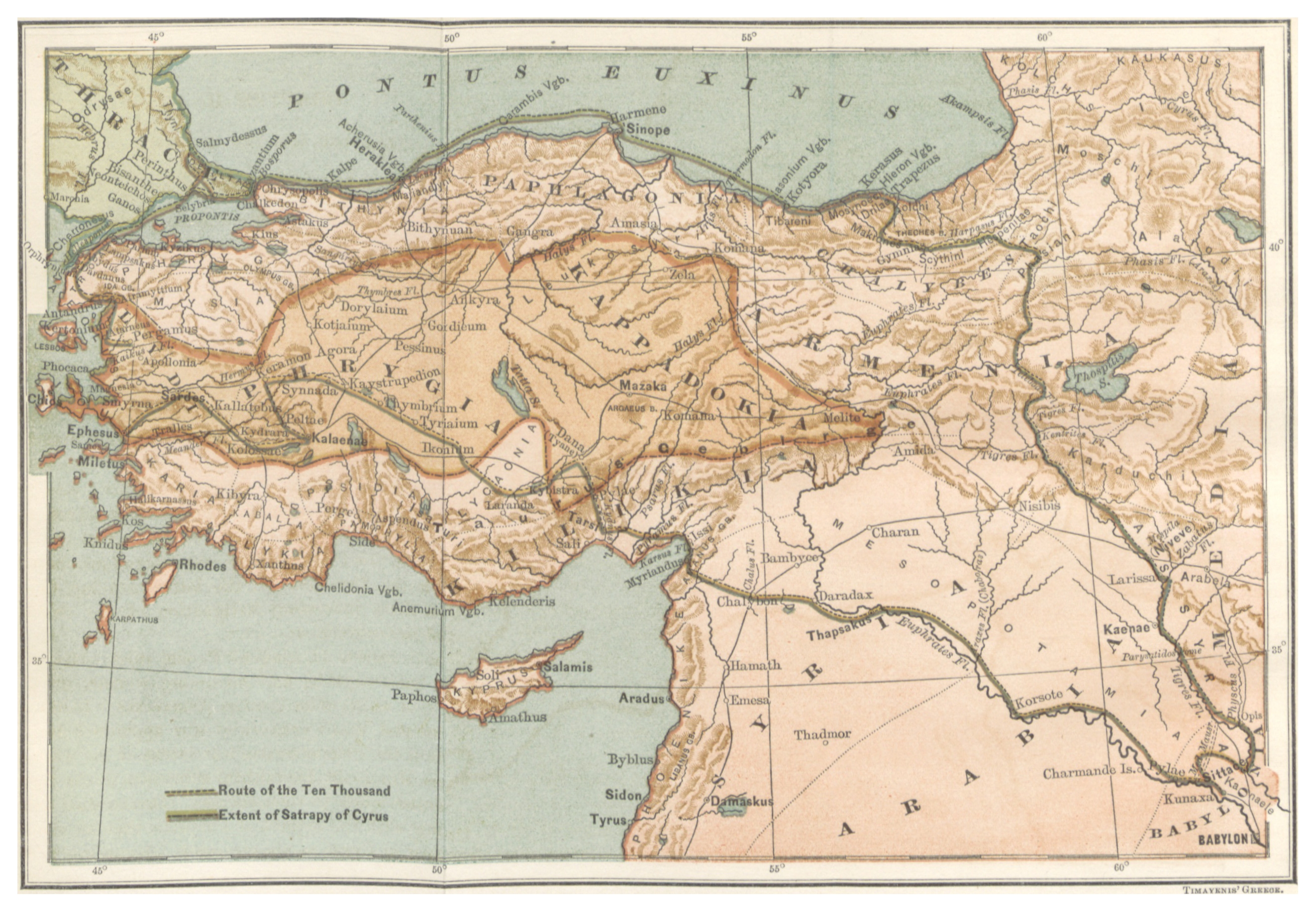
TIMAYENIS(1881) p1.422 THE MARCH OF CYRUS.jpg - Metilsteiner

Redeeming the republic - the third period of the war of the rebellion, in the year 1864 (1889) (14773161645).jpg - Fæ

History of Rome and the Roman people, from its origin to the establishment of the Christian empire (1884) (14741857236).jpg - SteinsplitterBot

A dictionary of the Bible.. (1887) (14781902895).jpg - SteinsplitterBot

A dictionary of the Bible.. (1887) (14595392957).jpg - Fæ

A dictionary of the Bible.. (1887) (14595257738).jpg - SteinsplitterBot

A dictionary of the Bible.. (1887) (14595256698).jpg - Fæ

A dictionary of the Bible.. (1887) (14779534654).jpg - Fæ

A dictionary of the Bible.. (1887) (14595180150).jpg - Fæ

A dictionary of the Bible.. (1887) (14595226549).jpg - Fæ

A dictionary of the Bible.. (1887) (14781539332).jpg - Fæ

A dictionary of the Bible.. (1887) (14595384047).jpg - SteinsplitterBot

A dictionary of the Bible.. (1887) (14595085170).jpg - SteinsplitterBot

A dictionary of the Bible.. (1887) (14781302622).jpg - Fæ

A dictionary of the Bible.. (1887) (14594953738).jpg - Fæ

A dictionary of the Bible.. (1887) (14779425814).jpg - Fæ

Andrew Pearce Stout. The journeys, and deeds of Jesus, and scriptoral index on a new map of Palestine. 1881.jpg - Geagea

A dictionary of the Bible.. (1887) (14758675376).jpg - Fæ

A dictionary of the Bible.. (1887) (14781750285).jpg - Fæ

An outline history of the United States, for public and other schools; (1881) (14784595603).jpg - SteinsplitterBot

An outline history of the United States, for public and other schools; (1881) (14741703096).jpg - SteinsplitterBot

An outline history of the United States, for public and other schools; (1881) (14761488441).jpg - Fæ

An outline history of the United States, for public and other schools; (1881) (14762275564).jpg - Fæ

Carré - Le Parlement de Bretagne après la Ligue (Illu. page 589).jpg - M0tty

Spruner-Menke Handatlas 1880 Karte 47.jpg - Lubiesque

Lower Nile.jpg - Amitchell125

Deutschland im XIV. Jahrhundert.jpg - FDRMRZUSA

Image taken from page 217 of 'Re-dedication of the Old State House, Boston, July 11, 1882. (With plates.)' (16589512952).jpg - Artix Kreiger 2

Image taken from page 217 of 'Re-dedication of the Old State House, Boston, July 11, 1882. (With plates.)' (15968009014).jpg - Artix Kreiger 2

149 of 'Historische Wanderung durch die alte Stadt Düsseldorf' (11200013776).jpg - Artix Kreiger 2

142 of 'A history of the United States and its people, for the use of Schools' (11104961813).jpg - Artix Kreiger 2
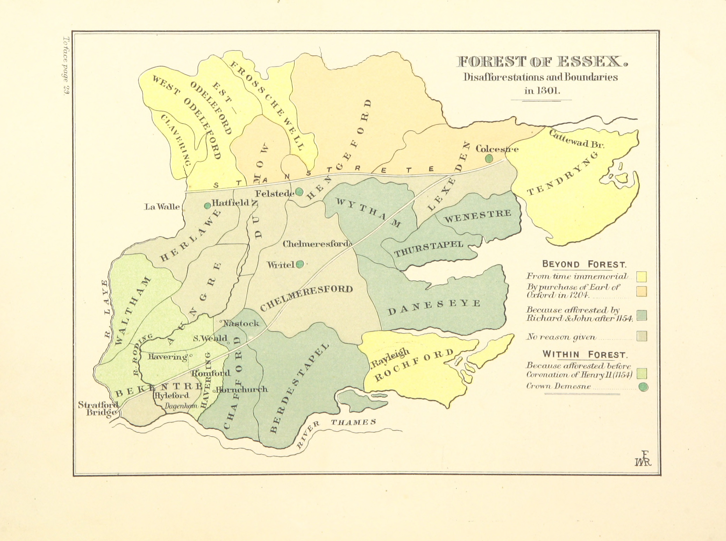
FISHER(1888) p48 - Forest of Essex. Disafforestations and Boundaries in 1301.jpg - FlickreviewR 2

257 of 'The Reign of William Rufus and the accession of Henry the First' (11159129223).jpg - Artix Kreiger 2

Image taken from page 18 of 'The Pharaohs and their People. Scenes of old Egyptian life and history ... With numerous illustrations' (11171070124).jpg - Artix Kreiger 2

93 of 'The Old Northwest, with a view of the thirteen colonies as constituted by the Royal Charters' (11197544933).jpg - FlickreviewR 2

203 of 'The Old Northwest, with a view of the thirteen colonies as constituted by the Royal Charters' (11193925365).jpg - FlickreviewR 2

219 of 'The Old Northwest, with a view of the thirteen colonies as constituted by the Royal Charters' (11197913104).jpg - FlickreviewR 2

157 of 'A History of London ... With maps and illustrations ... Second edition, revised and enlarged' (11167372605).jpg - Artix Kreiger 2

10 of 'A History of London ... With maps and illustrations ... Second edition, revised and enlarged' (11172423914).jpg - Artix Kreiger 2

333 of 'Neue Folge' (11186151104).jpg - Artix Kreiger 2

457 of 'Neue Folge' (11191141843).jpg - Artix Kreiger 2

171 of 'Alt- und Neu-Wien. Geschichte der Kaiserstadt und ihrer Umgebungen, etc' (11275637274).jpg - Artix Kreiger 2

114 of 'The Youth's History of the United States, etc' (11191099863).jpg - Artix Kreiger 2

351 of 'The Youth's History of the United States, etc' (11190315526).jpg - FlickreviewR 2

344 of 'The Youth's History of the United States, etc' (11187387234).jpg - Artix Kreiger 2

Image taken from page 393 of 'Děje Království Českého ... Páté, poopravené a třemi mapami rozmnožené vydání. (Výklad ke ... mapám. Napsal ... J. Kalousek.)' (11174838534).jpg - Artix Kreiger 2

Image taken from page 391 of 'Děje Království Českého ... Páté, poopravené a třemi mapami rozmnožené vydání. (Výklad ke ... mapám. Napsal ... J. Kalousek.)' (11176072693).jpg - Artix Kreiger 2

Image taken from page 395 of 'Děje Království Českého ... Páté, poopravené a třemi mapami rozmnožené vydání. (Výklad ke ... mapám. Napsal ... J. Kalousek.)' (11180857695).jpg - Artix Kreiger 2

419 of 'Zur rumänisch-ungarischen Streitfrage. Skizzen zur ältesten Geschichte der Rumänen, Ungarn und Slaven' (11184019103).jpg - Artix Kreiger 2

22 of 'History of Clinton and Franklin Counties, New York. With illustrations and biographical sketches of its prominent men and pioneers' (11078698533).jpg - Artix Kreiger 2

392 of 'La France Illustrée- géographie générale ... Par F. J' (11292231994).jpg - Artix Kreiger 2

Deutschland im XV. Jahrhundert.jpg - FDRMRZUSA

Deutschland im XVI. Jahrhundert.jpg - FDRMRZUSA

Deutschland im XVIII. Jahrhundert.jpg - FDRMRZUSA

(Spruner-Menke, map 17) The Iberian peninsula 1257-1492.jpg - FDRMRZUSA

(Spruner-Menke, map 19) The Iberian peninsula at the start of the 16th century.jpg - FDRMRZUSA

(Spruner-Menke, map 14) The Iberian peninsula 531-711.jpg - FDRMRZUSA
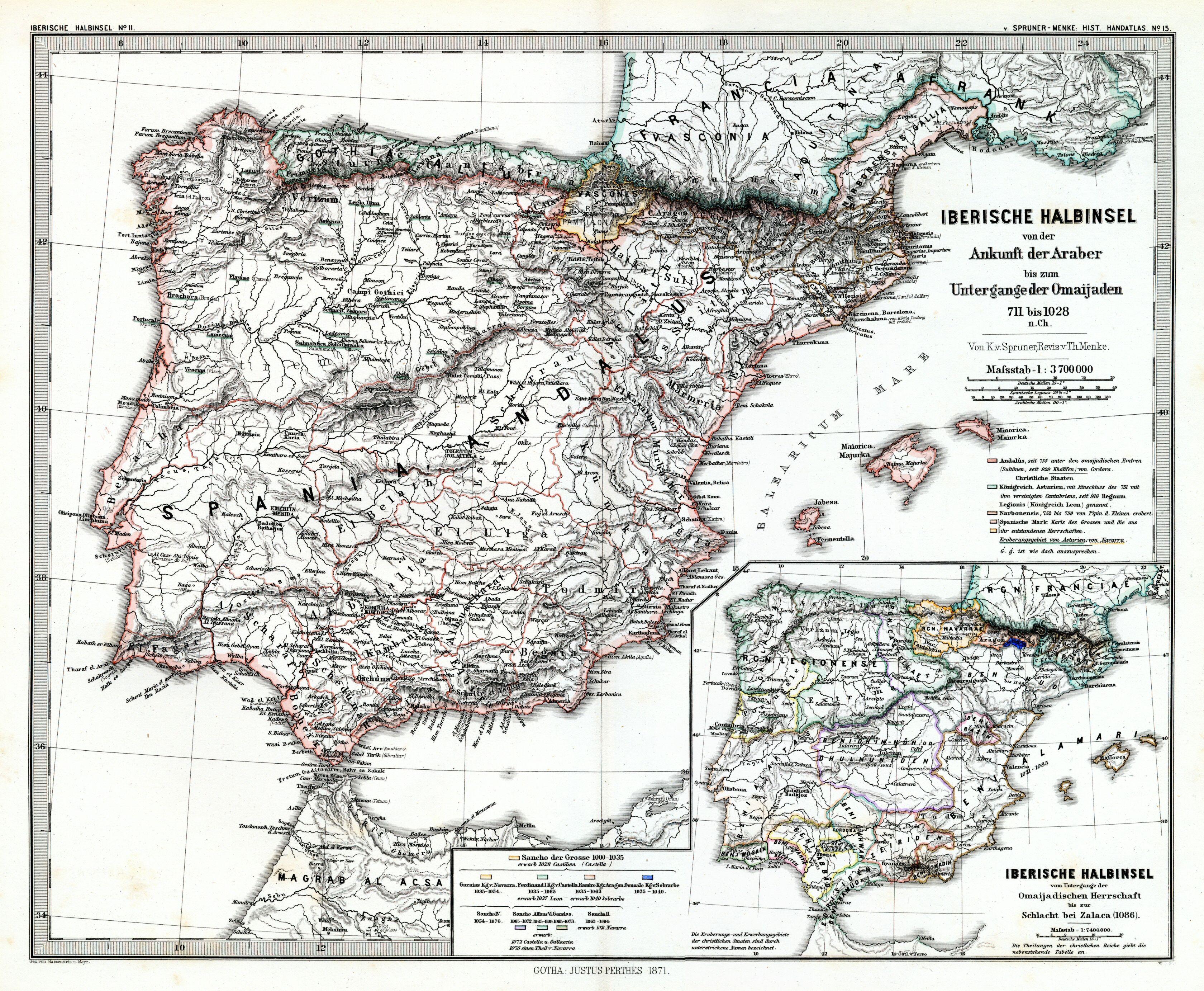
(Spruner-Menke, map 15) The Iberian peninsula 711-1028.jpg - FDRMRZUSA

(Spruner-Menke, map 16) The Iberian peninsula 1086-1257.jpg - FDRMRZUSA

A General History for Colleges and High Schools - Map 2.png - Sp1nd01

A General History for Colleges and High Schools - Map 14.png - Sp1nd01

A General History for Colleges and High Schools - Map 15.jpg - Sp1nd01

A General History for Colleges and High Schools - Map 16.png - Sp1nd01

A General History for Colleges and High Schools - Map 17.png - Sp1nd01
A General History for Colleges and High Schools - Map 18.png - Sp1nd01

A General History for Colleges and High Schools - Map 19.png - Sp1nd01

A General History for Colleges and High Schools - Map 20 Part 1.png - Sp1nd01

A General History for Colleges and High Schools - Map 20 part 2.png - Sp1nd01

A General History for Colleges and High Schools - Map 13 Part 1.png - Sp1nd01

A General History for Colleges and High Schools - Map 13 Part 2.png - Sp1nd01

A General History for Colleges and High Schools - Map 12 Part 1.png - Sp1nd01

A General History for Colleges and High Schools - Map 12 Part 2.png - Sp1nd01

A General History for Colleges and High Schools - Map 11 Part 1.png - Sp1nd01

A General History for Colleges and High Schools - Map 11 Part 2.png - Sp1nd01

A General History for Colleges and High Schools - Map 10 Part 1.png - Sp1nd01

A General History for Colleges and High Schools - Map 10 Part 2.png - Sp1nd01

A General History for Colleges and High Schools - Map 9 Part 1.png - Sp1nd01

A General History for Colleges and High Schools - Map 9 Part 2.png - Sp1nd01

A General History for Colleges and High Schools - Map 8 Part 1.png - Sp1nd01

A General History for Colleges and High Schools - Map 8 Part 2.png - Sp1nd01

A General History for Colleges and High Schools - Map 7 Part 1.png - Sp1nd01

A General History for Colleges and High Schools - Map 7 Part 2.png - Sp1nd01

A General History for Colleges and High Schools - Map 3 Part 1.png - Sp1nd01

A General History for Colleges and High Schools - Map 4 Part 1.png - Sp1nd01

A General History for Colleges and High Schools - Map 4 Part 2.png - Sp1nd01

A General History for Colleges and High Schools - Map 5 Part 1.png - Sp1nd01

A General History for Colleges and High Schools - Map 5 Part 2.png - Sp1nd01

A General History for Colleges and High Schools - Map 6 Part 1.png - Sp1nd01

A General History for Colleges and High Schools - Map 6 Part 2.png - Sp1nd01

Osteuropa BV044856439.jpg - H.bauer26

Moskauer Reich BV044856508.jpg - H.bauer26

Kulikowo Pole BV044856530.jpg - H.bauer26

Turkmenistan BV042517122.jpg - Enyavar

Chittim (1887) (14595257738) (cropped).jpg - Geagea

St. Blasien-Bonndorf - 1789.jpg - Lubiesque

A Plan of Rome ancient and modern - by John Henry Parker... - btv1b53021008r (1 of 2).jpg - Gzen92Bot

A Plan of Rome ancient and modern - by John Henry Parker... - btv1b53021008r (2 of 2).jpg - Gzen92Bot

Elsass im Jahre 1789 - entworfen von Prof.Dr.M.Kirchner in Duisburg... - btv1b102233576.jpg - Gzen92Bot

Elsass im Jahre 1648 - entworfen von Dr. M. Kirchner. Die topographische Grundlage ; nach der fransösischen Generalatabskarte in 1 - 320 000 , die Flurgrenzen der Orte nach der französischen Generalkarte in 1 - 80.... - btv1b84941679.jpg - Gzen92Bot

Elsass im Jahre 1648 - Die topographische Grundlage ; nach der fransösischen Generalatabskarte in 1 - 320 000 , die Flurgrenzen der Orte nach der französischen Generalkarte in 1 - 80. 000 - entworfen von Dr M.... - btv1b10223356r.jpg - Gzen92Bot

Elsass im Jahre 1789 - entworfen von Prof.Dr.M.Kirchner in Duisburg... - btv1b531025828.jpg - Gzen92Bot

A. Brecher's Darstellung der territorialen Entwickelung des brandenburgisch-preussischen Staates, von 1415 bis jetzt, mit besonderer Berücksichtigung der deutschen Geschichte (Zehnte... Auflage) - btv1b84394462 (1 of 2).jpg - Gzen92Bot

Jesse Lyman Hurlbut, The kingdom of Herod the great (FL37128438 3909026).jpg - Geagea

Jesse Lyman Hurlbut, The Old Testament World (FL46962224 3908830).jpg - Geagea

Simond - L'Afghanistan, les Russes aux portes de l'Inde - Carte de l'Afghanistan.jpg - Ælfgar

129 - États-Unis au XVIIIe siècle - Géographie historique. Leçons en regard des cartes.jpg - Enyavar

Balkans in 1350 (134038106).jpg - Redaktor GLAM