Wikimedi'Òc
Modes d'emploi

Cet album fait partie des albums
Cet album photos contient les sous-albums suivants :


Meyers b7 s0761a.jpg - Mapmarks

Frankrike och england 1180.jpg - Hedning~commonswiki
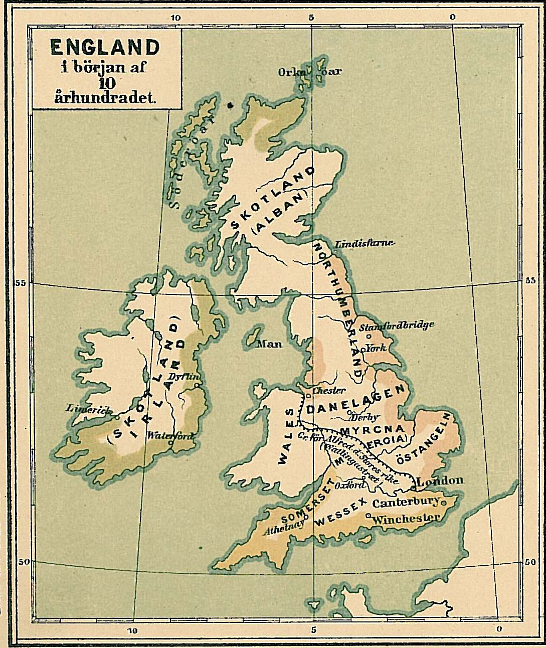
England i början av 900-talet.jpg - Hedning~commonswiki

Lighthouses and Lightships British Islands.jpg - Kogo

The earth and its inhabitants (1881) (14781875964).jpg - SteinsplitterBot

The earth and its inhabitants (1881) (14781070241).jpg - SteinsplitterBot
The earth and its inhabitants (1881) (14783861172).jpg - SteinsplitterBot

Dairy farming - being the theory, practice, and methods of dairying (1880) (20643405499).jpg - Fæ

Yachts and yachting - with over one hundred and ten illustrations (1887) (14782926102).jpg - Fæ

The Bakerian Lecture- A Magnetic Survey of the British Isles for the Epoch January 1, 1886 (1890) (14802430293).jpg - Fæ

The Bakerian Lecture- A Magnetic Survey of the British Isles for the Epoch January 1, 1886 (1890) (14759574696).jpg - Fæ

The Bakerian Lecture- A Magnetic Survey of the British Isles for the Epoch January 1, 1886 (1890) (14802427873).jpg - Fæ

The Bakerian Lecture- A Magnetic Survey of the British Isles for the Epoch January 1, 1886 (1890) (14782215352).jpg - Fæ

The Bakerian Lecture- A Magnetic Survey of the British Isles for the Epoch January 1, 1886 (1890) (14780207314).jpg - Fæ

The Bakerian Lecture- A Magnetic Survey of the British Isles for the Epoch January 1, 1886 (1890) (14596061137).jpg - Fæ

The Bakerian Lecture- A Magnetic Survey of the British Isles for the Epoch January 1, 1886 (1890) (14595854050).jpg - Fæ

The Bakerian Lecture- A Magnetic Survey of the British Isles for the Epoch January 1, 1886 (1890) (14595813460).jpg - Fæ

Spruner-Menke Handatlas 1880 Karte 58.jpg - A. Wagner

Spruner-Menke Handatlas 1880 Karte 60.jpg - A. Wagner

Spruner-Menke Handatlas 1880 Karte 59.jpg - A. Wagner

Spruner-Menke Handatlas 1880 Karte 61.jpg - A. Wagner

Image taken from page 221 of '(Handbook of Commercial Geography.)' (16588537521).jpg - Artix Kreiger 2

Image taken from page 947 of 'Gazetteer of the British Isles, statistical and topographical. Edited by J. Bartholomew. With appendices and special maps and plans' (16404345119).jpg - Artix Kreiger 2

Image taken from page 947 of 'Gazetteer of the British Isles, statistical and topographical. Edited by J. Bartholomew. With appendices and special maps and plans' (11191943836) (2).jpg - FlickreviewR 2

Image taken from page 947 of 'Gazetteer of the British Isles, statistical and topographical. Edited by J. Bartholomew. With appendices and special maps and plans' (16589544682).jpg - Artix Kreiger 2

Image taken from page 221 of 'Handbook of Commercial Geography' (16404260719).jpg - Artix Kreiger 2

117 of 'Geology in systematic notes and tables for the use of teachers and of taught. ... With ... illustrations and a geological map of Great Britain. Second edition' (11201953855).jpg - Artix Kreiger 2

24 of 'Our Seamarks; a plain account of the Lighthouses, ... Buoys, and Fog-signals maintained on our Coasts. ... With ... illustrations' (11166466436).jpg - SteinsplitterBot

142 of 'Sea Pictures, drawn with pen and pencil' (11154671394).jpg - Artix Kreiger 2

64 of 'Contributions to the Physical History of the British Isles. With a dissertation on the origin of Western Europe, and of the Atlantic Ocean. Illustrated by ... coloured maps' (11083973354).jpg - Artix Kreiger 2

50 of 'Physiography ... New edition' (11165927415).jpg - FlickreviewR 2

51 of 'Physiography ... New edition' (11166462814).jpg - FlickreviewR 2

206 of 'Contributions to the Physical History of the British Isles. With a dissertation on the origin of Western Europe, and of the Atlantic Ocean. Illustrated by ... coloured maps' (11158877345).jpg - Artix Kreiger 2

179 of 'The Races of Great Britain. A contribution to the anthropology of Western Europe. (With plates and maps.)' (11175715845).jpg - SteinsplitterBot

225 of 'The Races of Great Britain. A contribution to the anthropology of Western Europe. (With plates and maps.)' (11176801375).jpg - SteinsplitterBot

227 of 'The Races of Great Britain. A contribution to the anthropology of Western Europe. (With plates and maps.)' (11180213174).jpg - SteinsplitterBot

229 of 'The Races of Great Britain. A contribution to the anthropology of Western Europe. (With plates and maps.)' (11178314256).jpg - SteinsplitterBot

231 of 'The Races of Great Britain. A contribution to the anthropology of Western Europe. (With plates and maps.)' (11178251186).jpg - SteinsplitterBot

178 of 'Contributions to the Physical History of the British Isles. With a dissertation on the origin of Western Europe, and of the Atlantic Ocean. Illustrated by ... coloured maps' (11154452084).jpg - Artix Kreiger 2

182 of 'Contributions to the Physical History of the British Isles. With a dissertation on the origin of Western Europe, and of the Atlantic Ocean. Illustrated by ... coloured maps' (11157423533).jpg - Artix Kreiger 2

186 of 'Contributions to the Physical History of the British Isles. With a dissertation on the origin of Western Europe, and of the Atlantic Ocean. Illustrated by ... coloured maps' (11150734976).jpg - Artix Kreiger 2

190 of 'Contributions to the Physical History of the British Isles. With a dissertation on the origin of Western Europe, and of the Atlantic Ocean. Illustrated by ... coloured maps' (11152823323).jpg - Artix Kreiger 2

174 of 'Contributions to the Physical History of the British Isles. With a dissertation on the origin of Western Europe, and of the Atlantic Ocean. Illustrated by ... coloured maps' (11158858316).jpg - Kilom691

202 of 'Contributions to the Physical History of the British Isles. With a dissertation on the origin of Western Europe, and of the Atlantic Ocean. Illustrated by ... coloured maps' (11148410156).jpg - Artix Kreiger 2

207 of 'Contributions to the Physical History of the British Isles. With a dissertation on the origin of Western Europe, and of the Atlantic Ocean. Illustrated by ... coloured maps' (11152607634).jpg - Artix Kreiger 2

203 of 'Contributions to the Physical History of the British Isles. With a dissertation on the origin of Western Europe, and of the Atlantic Ocean. Illustrated by ... coloured maps' (11148692204).jpg - Artix Kreiger 2

210 of 'Contributions to the Physical History of the British Isles. With a dissertation on the origin of Western Europe, and of the Atlantic Ocean. Illustrated by ... coloured maps' (11160632084).jpg - Artix Kreiger 2

187 of 'Contributions to the Physical History of the British Isles. With a dissertation on the origin of Western Europe, and of the Atlantic Ocean. Illustrated by ... coloured maps' (11156242484).jpg - Artix Kreiger 2

191 of 'Contributions to the Physical History of the British Isles. With a dissertation on the origin of Western Europe, and of the Atlantic Ocean. Illustrated by ... coloured maps' (11148647566).jpg - Artix Kreiger 2

219 of 'Contributions to the Physical History of the British Isles. With a dissertation on the origin of Western Europe, and of the Atlantic Ocean. Illustrated by ... coloured maps' (11159022706).jpg - FlickreviewR 2

194 of 'Contributions to the Physical History of the British Isles. With a dissertation on the origin of Western Europe, and of the Atlantic Ocean. Illustrated by ... coloured maps' (11148432074).jpg - Artix Kreiger 2

195 of 'Contributions to the Physical History of the British Isles. With a dissertation on the origin of Western Europe, and of the Atlantic Ocean. Illustrated by ... coloured maps' (11160836943).jpg - Artix Kreiger 2

222 of 'Contributions to the Physical History of the British Isles. With a dissertation on the origin of Western Europe, and of the Atlantic Ocean. Illustrated by ... coloured maps' (11152157113).jpg - Artix Kreiger 2

223 of 'Contributions to the Physical History of the British Isles. With a dissertation on the origin of Western Europe, and of the Atlantic Ocean. Illustrated by ... coloured maps' (11160625886).jpg - Artix Kreiger 2

183 of 'Contributions to the Physical History of the British Isles. With a dissertation on the origin of Western Europe, and of the Atlantic Ocean. Illustrated by ... coloured maps' (11156447864).jpg - Artix Kreiger 2

211 of 'Contributions to the Physical History of the British Isles. With a dissertation on the origin of Western Europe, and of the Atlantic Ocean. Illustrated by ... coloured maps' (11154937113).jpg - Artix Kreiger 2

215 of 'Contributions to the Physical History of the British Isles. With a dissertation on the origin of Western Europe, and of the Atlantic Ocean. Illustrated by ... coloured maps' (11152367556).jpg - Artix Kreiger 2

199 of 'Contributions to the Physical History of the British Isles. With a dissertation on the origin of Western Europe, and of the Atlantic Ocean. Illustrated by ... coloured maps' (11150672604).jpg - Artix Kreiger 2

342 of 'Physiography ... New edition' (11285973884).jpg - Artix Kreiger 2
628 of 'The British Isles ... (Translated from “Nouvelle Géographie Universelle.”) Edited by E. G. Ravenstein ... Illustrated, etc' (11288398676).jpg - Artix Kreiger 2
632 of 'The British Isles ... (Translated from “Nouvelle Géographie Universelle.”) Edited by E. G. Ravenstein ... Illustrated, etc' (11188800215).jpg - Artix Kreiger 2
643 of 'The British Isles ... (Translated from “Nouvelle Géographie Universelle.”) Edited by E. G. Ravenstein ... Illustrated, etc' (11191781665).jpg - Artix Kreiger 2
616 of 'The British Isles ... (Translated from “Nouvelle Géographie Universelle.”) Edited by E. G. Ravenstein ... Illustrated, etc' (11187984053).jpg - Artix Kreiger 2
650 of 'The British Isles ... (Translated from “Nouvelle Géographie Universelle.”) Edited by E. G. Ravenstein ... Illustrated, etc' (11186417004).jpg - Artix Kreiger 2
617 of 'The British Isles ... (Translated from “Nouvelle Géographie Universelle.”) Edited by E. G. Ravenstein ... Illustrated, etc' (11186946093).jpg - Artix Kreiger 2
631 of 'The British Isles ... (Translated from “Nouvelle Géographie Universelle.”) Edited by E. G. Ravenstein ... Illustrated, etc' (11189208835).jpg - Artix Kreiger 2
658 of 'The British Isles ... (Translated from “Nouvelle Géographie Universelle.”) Edited by E. G. Ravenstein ... Illustrated, etc' (11190865883).jpg - Artix Kreiger 2
642 of 'The British Isles ... (Translated from “Nouvelle Géographie Universelle.”) Edited by E. G. Ravenstein ... Illustrated, etc' (11188513776).jpg - Artix Kreiger 2
645 of 'The British Isles ... (Translated from “Nouvelle Géographie Universelle.”) Edited by E. G. Ravenstein ... Illustrated, etc' (11190412686).jpg - Artix Kreiger 2

23 of 'Anvers port de mer. Description du port et des établissements maritimes d'Anvers, etc. (By G. Rogers, E. de Keyser, P. de Wit and C. G. Haenen.)' (11179483664).jpg - Artix Kreiger 2

Roman Britain (Droysen).jpg - FDRMRZUSA

Admiralty Chart No 1 British Islands to the Mediterranean Sea, Published 1884.jpg - Kognos
Gazetteer of the British Isles, statistical and topographical (1887) by John Bartholomew. Original from British Library. Digitally enhanced by rawpixel. (50623611561).jpg - Eyes Roger

Stumme physikalische Wandkarte der Britischen Inseln (Dritte Lieferung) - Richard Kiepert's Schul-Wand-Atlas des Länder Europa's - btv1b53021110z.jpg - Gzen92Bot