Wikimedi'Òc
Modes d'emploi

Cet album fait partie des albums
Cet album photos contient les sous-albums suivants :


Seekarte Pillau 1880.jpg - ArtMechanic

DonauWutachRhein1880.png - Ulamm
Cosmographia Northern Europe 1482.jpg - Pieter Kuiper

Map courbevoie.jpg - Jonathanriley

PSM V16 D306 World weather map jan 25 1878.jpg - Ineuw

PSM V16 D321 Chart of storm tracks of north pacific ocean.jpg - Ineuw

PSM V16 D323 Cyclone crossing from north america to europe.jpg - Ineuw

PSM V16 D329 Chart of equal barometric pressures in and around north america.jpg - Ineuw

PSM V16 D402 Proposed canal routes between the two oceans.jpg - Ineuw

PSM V16 D404 Commercial shipping routes of convenience to the proposed canal.jpg - Ineuw
PSM V16 D306 Weather map western hemisphere 130 to 50 longitude.jpg - Ineuw

PSM V16 D456 Weather map eastern hemisphere 50 to 130 longitude.jpg - Ineuw

Hamburg.1880.hafen.gaedechens 300dpi.jpg - Wmeinhart

1880 Perthes - Stieler Map of the Moon - Geographicus - Moon-stieler-1870.jpg - BotMultichill

Die Gartenlaube (1880) b 592.jpg - THX-1138

1880 Map on Chippy withj Horse Racing.png - Antarchie

OABalingen-Karte.jpg - 9xl

Geologische Karte der Stadt Berlin, 1880.jpg - Alexrk2

TK25 Sachsen Äquidistantenkarte Montage Gewässerknoten Leipzig und Elsteraue 1880 (websave,12c).png - Cmuelle8
TK25 Sachsen Äquidistantenkarte Montage Leipziger Gewässerknoten und Elsteraue 1880.jpg - Cmuelle8

EB9 Hawaiian Islands.jpg - Bob Burkhardt

Johnsons Virginia, Delaware, Maryland & West Virginia (8347522484).jpg - File Upload Bot (Magnus Manske)

Taylor Co., West Va. (4231295363).jpg - File Upload Bot (Magnus Manske)

Map of the city of Wheeling, West Virginia (4231295673).jpg - File Upload Bot (Magnus Manske)

Marion Co. (4232063210).jpg - File Upload Bot (Magnus Manske)

Putnam Co., West Virginia (4231295183).jpg - File Upload Bot (Magnus Manske)

Plan of Lafayette College grounds Easton, Pa. (4231294189).jpg - File Upload Bot (Magnus Manske)

The Point of Pines, Revere, Mass. (2675192483).jpg - File Upload Bot (Magnus Manske)

Ttahuantin-Suyu or the empire of the Yncas (except Quito and Chile) ... conquerers (2674940001).jpg - File Upload Bot (Magnus Manske)

Proposed Charles River Park (2674989128).jpg - File Upload Bot (Magnus Manske)
Pegau Messtischblatt df dk 0000210 4839 1880.jpg - Cmuelle8

Zwenkau Alte Elster und Altes Elsterwehr Fischerwinkel Mückenhaynwiese Döhlen 1880.jpg - Cmuelle8

2fi1090 Plan de Rennes avec projet de crèche Saint-Hélier.jpg - Daieuxetdailleurs

Spezialkarte der Österreichisch-ungarischen Monarchie - Görz und Gradisca 1880.jpg - Sporti

Spezialkarte der Österreichisch-ungarischen Monarchie - Triest 1880.jpg - Sporti

Spezialkarte der Österreichisch-ungarischen Monarchie - Bischoflack und Oberidria 1880.jpg - Sporti

Spezialkarte der Österreichisch-ungarischen Monarchie - Mozirje 1880.jpg - Sporti

Spezialkarte der Österreichisch-ungarischen Monarchie - Ljubljana 1880.jpg - Sporti

Plan cadastral 1880 Île-Tudy.jpg - Moreau.henri

Map of Taiwan and the Pescadores Islands WDL208.png - Fæ
Braunau und Triftern. NYPL1226497.tiff - Fæ
Appendix. (cont.) NYPL1584499.tiff - Fæ
Appendix. (cont.) NYPL1584498.tiff - Fæ
Appendix. (cont.) NYPL1584496.tiff - Fæ
Appendix. NYPL1584495.tiff - Fæ
Ashbel R. Sellew; Residence of Stephen R. Smith, Esq., Town of Concord.; Wm. Watkins NYPL1584595.tiff - Fæ
Boston (Township) NYPL1584584.tiff - Fæ
Boston (Village); North Boston (Village); Business Notices.; Boston Center Patchin P.O. (Village) NYPL1584585.tiff - Fæ
Bowmansville (Village); Cheektowaga (Township) NYPL1584539.tiff - Fæ
Cider Mill Res. of and Store of E. J. Markham, Elma, N.Y.; Res. of Cypus Hurd, Town of Elma, Erie Co., N.Y.; Res. of J. B. Briggs, Esq., Elma, Erie Co., N.Y.; Willow Dale Observatory, W. S. Van Duzee, NYPL1584560.tiff - Fæ
City and Town Histories. NYPL1584480.tiff - Fæ
City and Town Histories. (cont.) NYPL1584485.tiff - Fæ
City and Town Histories. (cont.) NYPL1584482.tiff - Fæ
City and Town Histories. (cont.) NYPL1584483.tiff - Fæ
City and Town Histories. (cont.) NYPL1584481.tiff - Fæ
City and Town Histories. (cont.); Town Histories. NYPL1584486.tiff - Fæ
City and Town Histories. (cont.) NYPL1584484.tiff - Fæ
Concord (Township); Morton's Corners (Village); Woodward's Hollow P.O. Concord (Village); East Concord (Village) NYPL1584594.tiff - Fæ
East Aurora (Village) NYPL1584572.tiff - Fæ
East Hamburg (Township) NYPL1584566.tiff - Fæ
East Part of Lancaster (Village) NYPL1584543.tiff - Fæ
E. M. Jewetts Coopering Establishment Buffalo, N.Y. Office 216 Washington, St.; Residence of G. Wolf. Flouring and Grist Mill of G and J. Wolf. Skinnersville Town of Amherst. Residence of J. Wolf. NYPL1584524.tiff - Fæ
Farnham Station Brant (Village); Beant (Township); Brant Center (Village) NYPL1584592.tiff - Fæ
Holland (Township) NYPL1584590.tiff - Fæ
Interior View of S. B. Thomson's General Store, " The Regulator, " 134 feet deep by 32 feet wide. East Aurora, N.Y.; Residence and Farm of Mr. S. Griggs, Aurora, N.Y.; Residence and Mills of L. NYPL1584569.tiff - Fæ
Klausen. -10150 (Small) NYPL1226716.tiff - Fæ
New Oregon P.O. (Village); North Collins (Village); North Collins (Township); Langford P.O. (Village); Shirley P.O. (Village) NYPL1584593.tiff - Fæ
North Part of Lancaster (Village); Crittenden (Village); Alden (Village); West Alden (Village); Alden Center (Village); Mill Grove (Village) NYPL1584544.tiff - Fæ
Spring Brook (Village); East Elma (Village) NYPL1584556.tiff - Fæ
Springville (Village) NYPL1584596.tiff - Fæ
Buffalo Fertilizer Works, Babook Street, East Buffalo.; Iron Sleigh Runners; Hardware Store Tin Shop and Residence of Joseph Kronenberg, N.Y.; Res. of John Eshelman; Res. of A. G. Eshelman; Res. of NYPL1584528.tiff - Fæ
Capt. Orson Shepard.; F. G. Osborne, Wales, N.Y.; Alvin Salisbury, Hamburg, N.Y.; C. Wait, M. D., Springville, N.Y. NYPL1584521.tiff - Fæ
Yeoman's Hotel, East Aurora, N.Y.; "Niagara View" NYPL1584514.tiff - Fæ
Windemere", Residence of R. M. Choaye, Abbott road, Buffalo, N.Y. ;Buffalo Park Parade House, Louis A. Buehl, Proprietor, Fine Wines, Liquors and Cigars. Also Hot and Cold Lunch Will be Served NYPL1584509.tiff - Fæ
Williamsville (Village) NYPL1584529.tiff - Fæ
West Part of Lancaster (Village); Town Line (Village) NYPL1584542.tiff - Fæ
Wales (Township) NYPL1584574.tiff - Fæ
Vol. 1. Plate, J. (Map bound by Decatur St., Patchen Ave., Buffalo Ave., Pacific Ave., Dean St., Troy Ave., Yates Ave; Including Bainbridge St., Chauncey, Marion St., Sumpter St., Fulton St., NYPL1627468.tiff - Fæ
View from Falconwood; Entrance from Falconwood; View from Piazza; "River Lawn". NYPL1584518.tiff - Fæ
Upper Ebenezer (Village); Elma (Village) NYPL1584554.tiff - Fæ
The World NYPL1584500.tiff - Fæ
The great cash one price and low price house of Barnes Bancroft & Co., 260 to 268 Main Street, Buffalo, Iron Front. (Advert) NYPL1584510.tiff - Fæ
The Bedell House, Grand Island. NYPL1584517.tiff - Fæ
Table of Contents.; Maps.; Illustrations. NYPL1584472.tiff - Fæ
Table of Air-Line Distances for Erie County, N.Y. NYPL1584473.tiff - Fæ

PEF map - ESDUD, Isdud-Ashdod and Wadi Sukereir-Lakhish 1880.jpg - Mr.Shoval
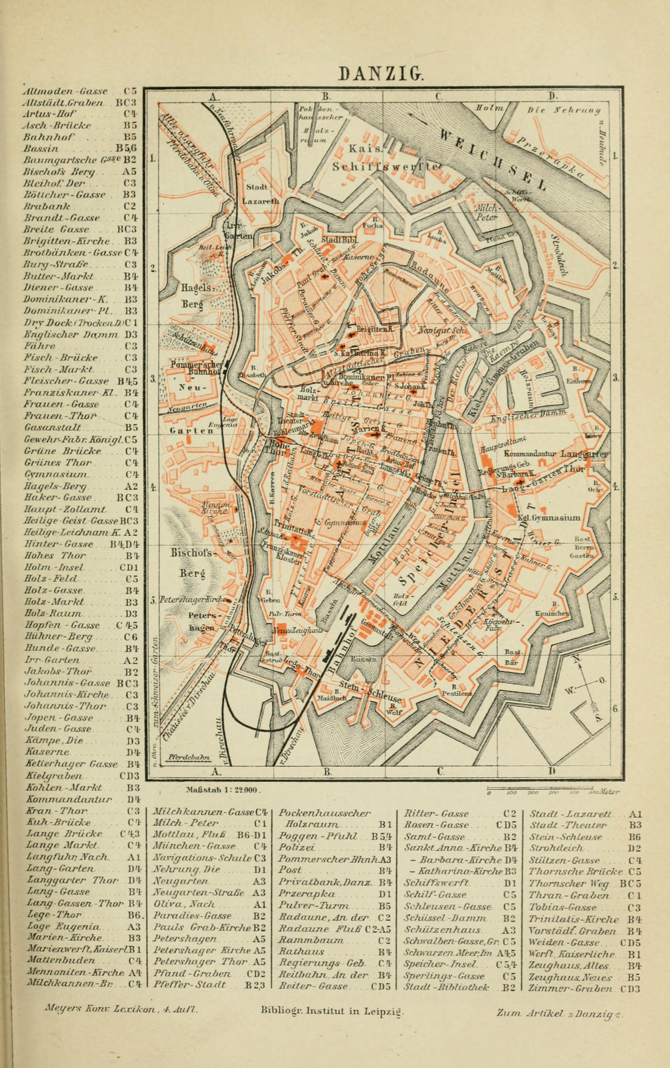
Meyers b4 s0538a.jpg - Mapmarks

Suomen rannikkoa 1880.jpg - Jonund

OABalingen-b540..jpg - Pfaerrich

Plan af Helsingfors jemte omgifning 1880.jpeg - Artturimatias
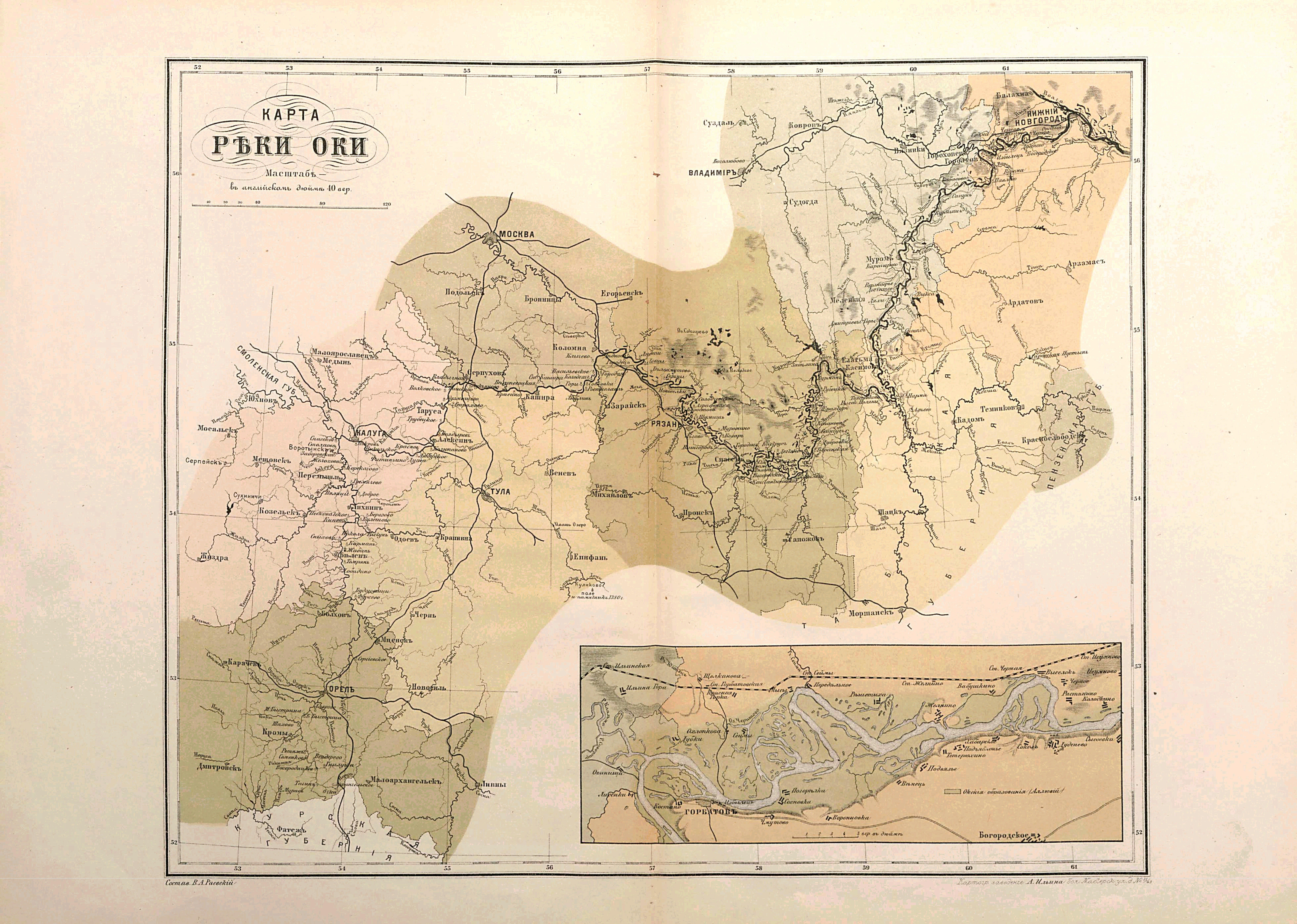
Karta reki Oka 1880.jpg - Well-Informed Optimist

United States Caribbean change 1880-09-13.png - Golbez

Annual report of the United States Geological Survey to the Secretary of the Interior (1898) (19182433539).jpg - Fæ

The American journal of science (1891) (17963632370).jpg - Fæ
Abhandlungen der Königlichen Akademie der Wissenschaften in Berlin (1880) (16579241820).jpg - Fæ
Karta-"Karta öfver Svenska arktiska expeditionernas forskningsområde åren 1837-80 - Sjöhistoriska museet - 1994-20.tif - SMMUploader

Field Notes, 1880 BHL45850534.jpg - Fæ

Bulletin de la Société géologique de France BHL47100151.jpg - Fæ

Bulletin de la Société géologique de France BHL47100408.jpg - Fæ

Map of Themar.png - SmThemar

Allée couverte de Kerbannalec - plan des fouilles 1880.jpg - Piero~commonswiki

Mauritius 1880 map by Descubes.jpg - Ratzer

1880 survey Sparks Shot Tower.png - Smallbones

Map of the Adirondacks, as reached by the Delaware and Hudson Canal Companys Railroad; Map of Lake George (10138206416).jpg - Ww2censor

276 of 'Vegas färd kring Asien och Europa, jemte en historisk återblick på föregående resor längs gamla verldens nordkust. (Illustrated.)' (11276511043).jpg - Artix Kreiger 2
Plat of lands lying between Mann's and Kenney's Creeks in Fayette Co., West Virginia, owned by Echols, Bell & Catlette, January 1880. LOC 2005625203.tif - Fæ

Plat of lands lying between Mann's and Kenney's Creeks in Fayette Co., West Virginia, owned by Echols, Bell & Catlette, January 1880. LOC 2005625203.jpg - Fæ
Southern hemisphere. LOC 85690345.tif - Fæ

Southern hemisphere. LOC 85690345.jpg - Fæ
Le'Droit Park as recorded in the Surveyor's Office - (Washington D.C.). LOC 88690891.tif - Fæ

Le'Droit Park as recorded in the Surveyor's Office - (Washington D.C.). LOC 88690891.jpg - Fæ

Map of the city of Utica LOC 2011593666.jpg - Fæ

Panoramic view of the city of Red Wing, Goddhue (sic) Co., Minnesota, 1880 LOC 85695665.jpg - Fæ
Map of Morgan and Johnson counties and parts of Magofin, Floyd and Martin LOC 2006629764.tif - Fæ

Map of Morgan and Johnson counties and parts of Magofin, Floyd and Martin LOC 2006629764.jpg - Fæ
Pekin yori Tenshin ni itaru LOC 92682875.tif - Fæ

Pekin yori Tenshin ni itaru LOC 92682875.jpg - Fæ
Northern hemisphere. LOC 85690344.tif - Fæ

Northern hemisphere. LOC 85690344.jpg - Fæ

A geographically correct county map of the states traversed by the Atchison Topeka and the Santa Fé Railroad and its connections. LOC 98688578.jpg - Fæ
(Map of the proposed enlargement and replanning of the Capitol grounds, Washington D.C.). LOC 88690773.tif - Fæ

(Map of the proposed enlargement and replanning of the Capitol grounds, Washington D.C.). LOC 88690773.jpg - Fæ
Map of the Thousand Island Park on Wellesley Island, River S't Lawrence - property of the Thousand Island Camp Meeting Association LOC 2003623841.tif - Fæ

Map of the Thousand Island Park on Wellesley Island, River S't Lawrence - property of the Thousand Island Camp Meeting Association LOC 2003623841.jpg - Fæ
Map of the Anacostia River or Eastern Branch region D.C. LOC 88690697.tif - Fæ

Map of the Anacostia River or Eastern Branch region D.C. LOC 88690697.jpg - Fæ
Report on the geology and resources of the Black Hills of Dakota - with atlas LOC 04001286.tif - Fæ

Report on the geology and resources of the Black Hills of Dakota - with atlas LOC 04001286.jpg - Fæ

Kōso-shō Kōnei-fu yori Santō-shō Enshū-fu ni itaru rojōzu LOC 92682885.jpg - Fæ
Map of the Shenandoah Valley, to illustrate the Valley Campaign of "Stonewall" Jackson, 1862- LOC 99448345.tif - Fæ

Map of the Shenandoah Valley, to illustrate the Valley Campaign of "Stonewall" Jackson, 1862- LOC 99448345.jpg - Fæ
Map of the grounds of the National Chautauqua of Glen Echo near Washington D.C. LOC 91686257.tif - Fæ

Map of the grounds of the National Chautauqua of Glen Echo near Washington D.C. LOC 91686257.jpg - Fæ
Map of the Pishin Valley and the upper basin of the Lora - constructed from the surveys & reconnaissances executed by officers attached to the forces serving in southern Afghanistan LOC 2004629228.tif - Fæ

Map of the Pishin Valley and the upper basin of the Lora - constructed from the surveys & reconnaissances executed by officers attached to the forces serving in southern Afghanistan LOC 2004629228.jpg - Fæ

Chōkō fukin no zu LOC 92682895.jpg - Fæ

Seikyō-shō dai 1-zu LOC 92682873.jpg - Fæ
Artillery School copies of Lieut. Hobbs' maps of Forts Foote & Washington, and Washington Arsenal - while these were under the military supervision of Brevet Major J. C. Breckinridge, Captain, 2d LOC 79695115.tif - Fæ

Artillery School copies of Lieut. Hobbs' maps of Forts Foote & Washington, and Washington Arsenal - while these were under the military supervision of Brevet Major J. C. Breckinridge, Captain, 2d LOC 79695115.jpg - Monopoly31121993(2)

Carte de la Galilée ancienne et moderne accompagnant la description géographique, historique et archéologique de la Palestine - ICP.jpg - Danny lost

@ - btv1b53006717g.jpg - Gzen92Bot

臺灣前後山全圖.jpg - Aldermanseven

The world of Herodotus (FL147409289 2726322).jpg - Geagea

Claude Reignier Conder, Map of Western Palestine in 26 sheets from the surveys conducted for the Committee of the Palestine Exploration Fund 27-index (FL199398532 2368494).jpg - Geagea

Claude Reignier Conder, Map of Western Palestine in 26 sheets from the surveys conducted for the Committee of the Palestine Exploration Fund 28-Title (FL199398533 2368494).jpg - Geagea

План расположения зданий Морского Ведомства во Владивостоке 1880.jpg - Любитель свежего воздуха

План окрестностей Владивостока 1889.jpg - Любитель свежего воздуха

دولت عليه نك آسيا طرفنده اولان ممالكى (FL4541536 2515006).jpg - Geagea

Victor Guérin, Carte de la Galilée ancienne et modern (FL37251509 2730191).jpg - Geagea

Birdseye view of Egypt (FL155332123 2715345).jpg - Geagea

The Harbour of Tor with a view of the mountains of Arabia Petreas seen from Tor (FL167486109 2703548).jpg - Geagea

Heinrich Kiepert, Übersichtsplan von Jerusalem 01 (FL198245553 1141892).jpg - Geagea
Heinrich Kiepert, Übersichtsplan von Jerusalem 02 (FL198245554 1141892).jpg - Geagea

August Heinrich Petermann, Ships routes from Europe to Egypt and Palestine (FL33142162 3881559).jpg - Geagea

Map of the countries south of the Dead Sea & Palestine. together with the peninsula of Mount Sinai and A part of Egypt (FL35098777 3892769).jpg - Geagea

A map of Canaan with the supposed portions of the Tribes (FL35103449 3892771).jpg - Geagea

Map of Judea in the time of Christ (FL35103458 3892773).jpg - Geagea

Dépot général de la Marine, Baie de Saint Jean d'Acre (FL36012365 3911464).jpg - Geagea

Palestina.Divisa nelle didici Tribù Anno 1444 a.C (FL36566230 3913590).jpg - Geagea
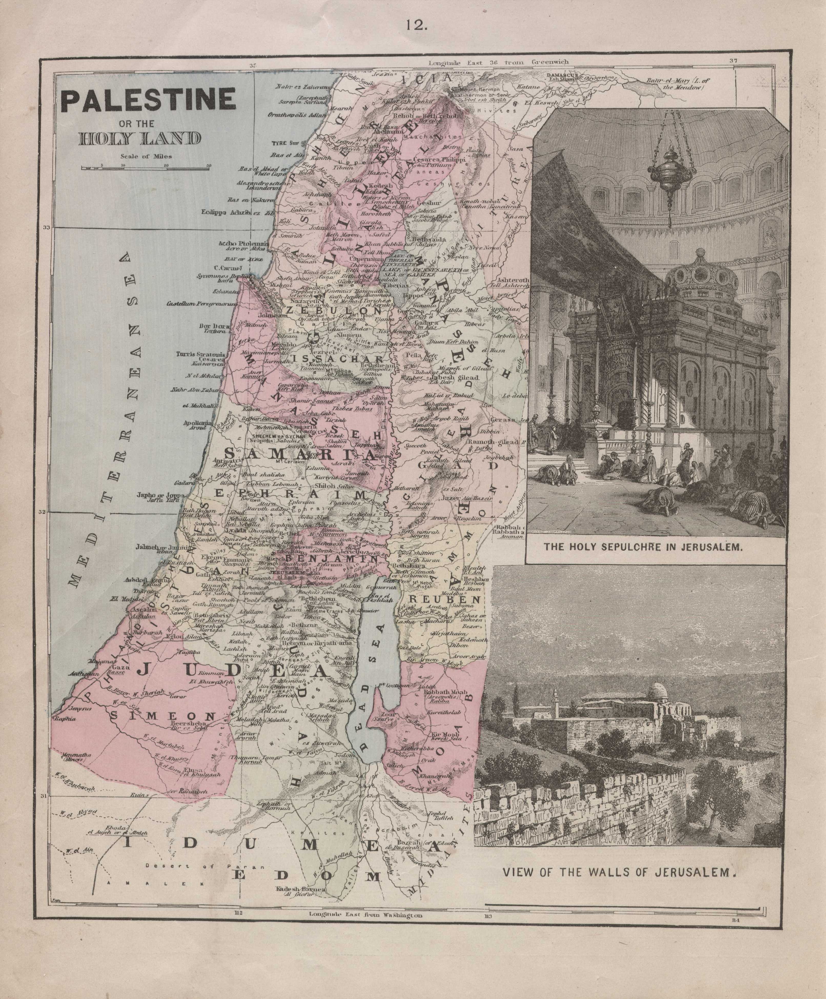
Palestine or the Holy Land (FL37116947 3893241).jpg - Geagea

Palestine (FL37821324 3922980).jpg - Geagea

Map of Jerusalem & its environs (FL49973296 4073124).jpg - Geagea

Hermann Berghaus, La Terra Santa (FL49973323 4073126).jpg - Geagea
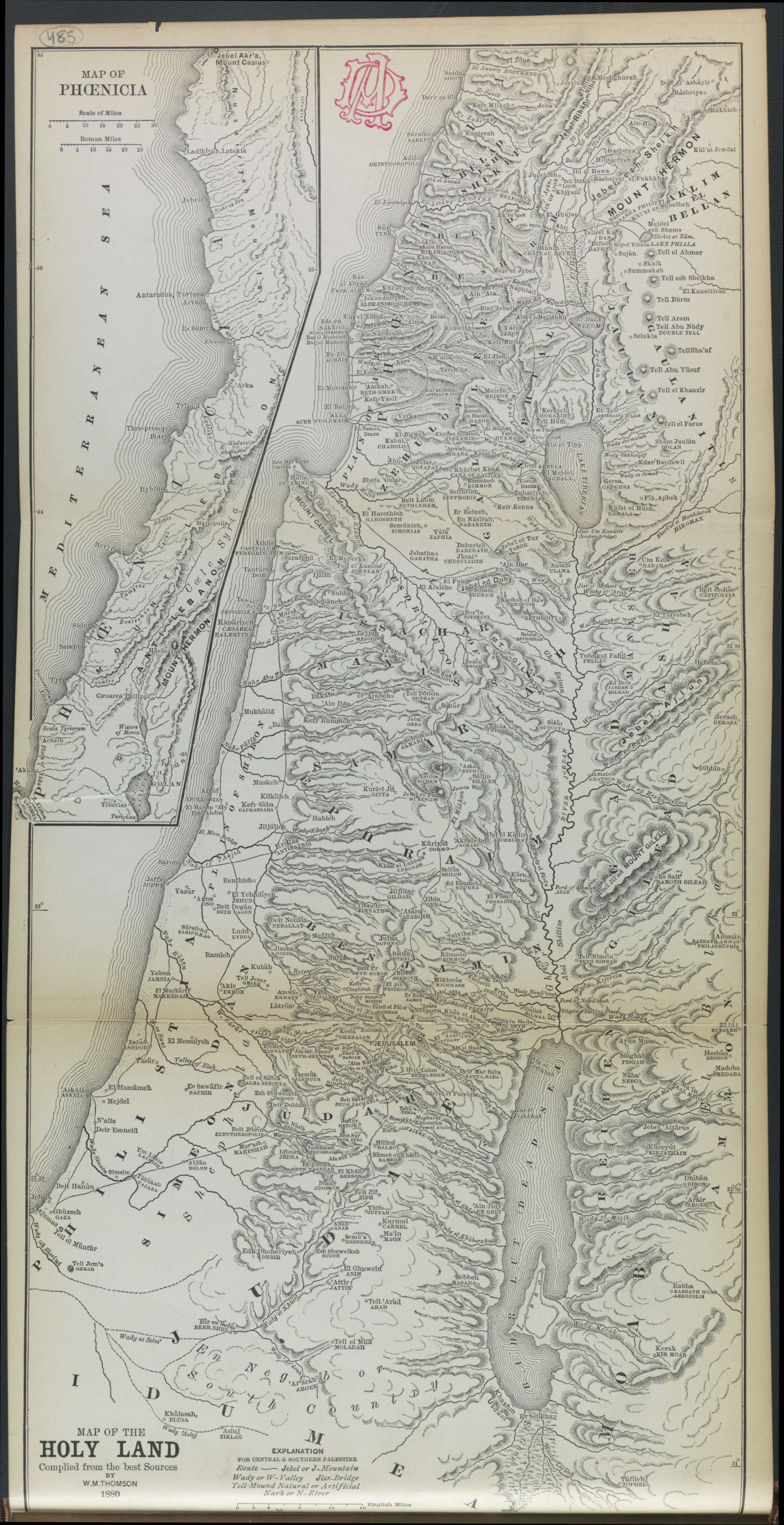
William McClure Thomson, Map of the Holy Land (FL49973560 4073172).jpg - Geagea

Theodor Sandel, Karte der Umgebung von Jafa (FL63660408 2783159).jpg - Geagea

Theodor Sandel, Umgebung von Yafa (FL6879560 2783215).jpg - Geagea

Theodor Sandel, Yâfa (FL6881777 2783325).jpg - Geagea

Heinrich Kiepert, Judäa (FL45584629 3927799).jpg - Geagea

Heinrich Kiepert, Übersichtsplan von Jerusalem (FL45584647 3927801).jpg - Geagea

Heinrich Kiepert, Weitere umgebung von Jerusalem bis Hebron, Jericho u zum Todtem Meer (FL45585257 3927875).jpg - Geagea

Heinrich Kiepert, Nahere umgebung von Jerusalem (FL45585260 3927813).jpg - Geagea
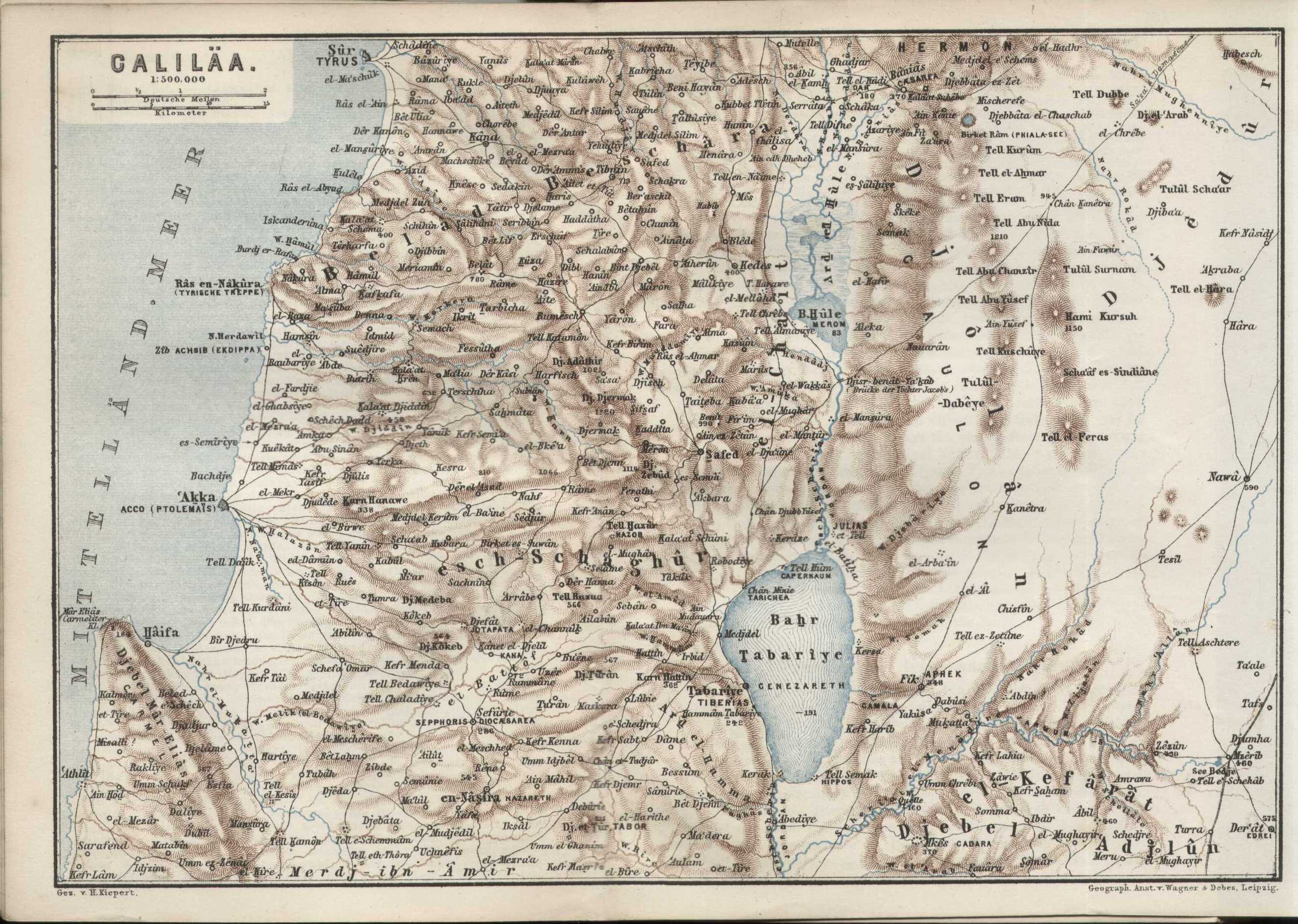
Heinrich Kiepert, Galiläa (FL45585263 3927895).jpg - Geagea

Karl Baedeker, Das nordliche Karmel - Gebirge (FL45585270 3927894).jpg - Geagea

Karl Baedeker, Nazareth (En - Nasira) (FL45585273 3927896).jpg - Geagea

1880 Japanese map of the Eastern Hemisphere.jpg - Balkanique

Rare 1880 Plan of LeDroit Park.jpg - Cochrate

Mappa Antica di Barletta.jpg - Bianower