Wikimedi'Òc
Modes d'emploi

Cet album fait partie des albums
Cet album photos contient les sous-albums suivants :


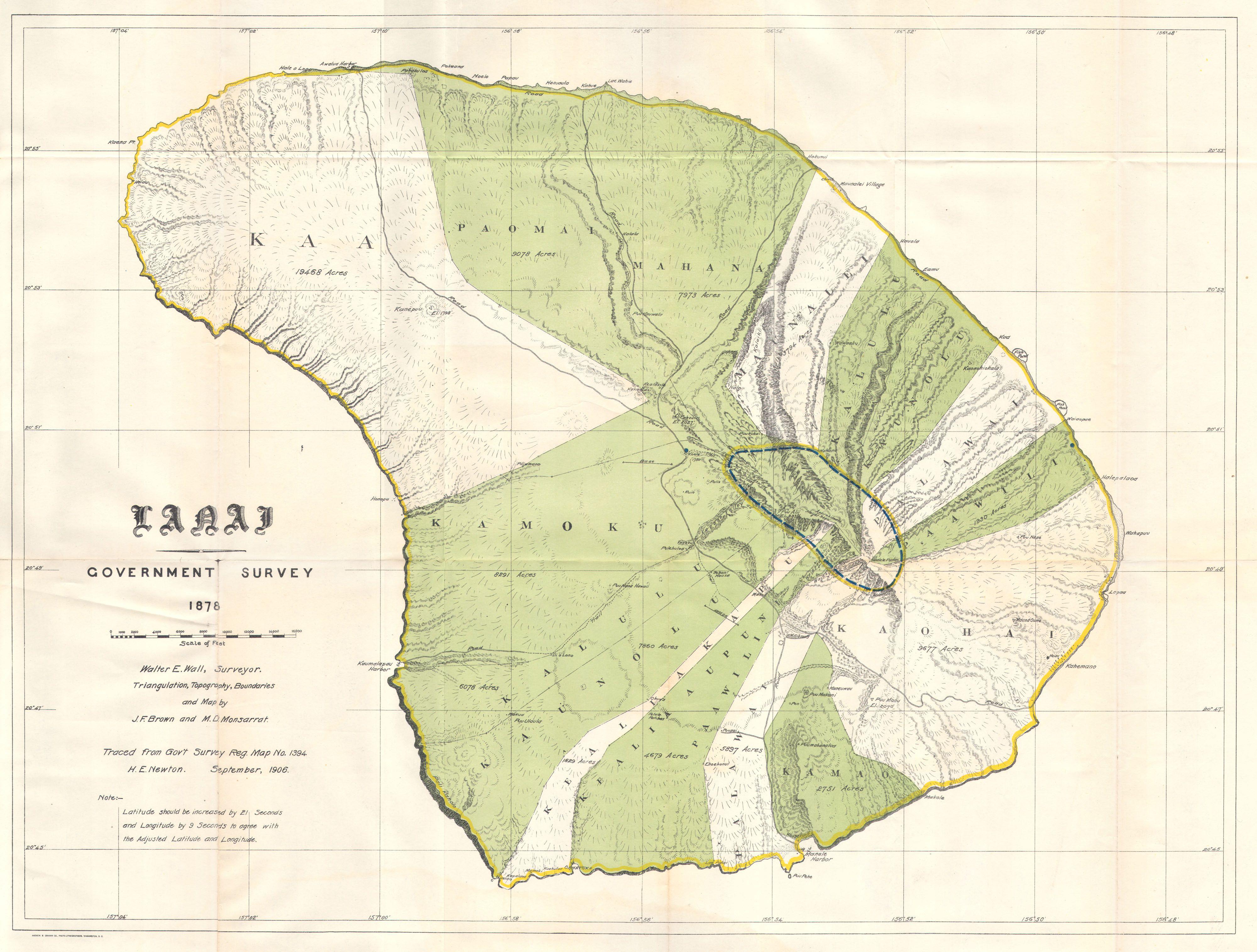
1878 Government Land Office Map of Lanai, Hawaii - Geographicus - LanaiHawaii-lo-1878.jpg - BotMultichillT

Memoirs of the Bernice Pauahi Bishop Museum of Polynesian Ethnology and Natural History (1899) (16770834095).jpg - Fæ

Image taken from page 259 of 'A Voyage in the “Sunbeam.” Our home on the ocean for eleven months ... With 188 illustrations ... chiefly after drawings by the Hon. A. Y. Bingham. (With a preface by Lord Brassey.)' (11121139344).jpg - Artix Kreiger 2

Image taken from page 173 of 'Voyage d'une famille autour du monde ... Traduit de l'anglais par J. Butler ... (Abridged.) Deuxième édition' (16404245239).jpg - Artix Kreiger 2

149 of 'Allgemeine Erdkunde ... Bearbeitet von Dr. J. Hann, Dr. F. v. Hochstetter und Dr. A. Pokorny ... Zweite vermehrte und verbesserte Auflage' (11064811504).jpg - Artix Kreiger 2

552 of 'The Earth and its Inhabitants. The European section of the Universal Geography by E. Reclus. Edited by E. G. Ravenstein. Illustrated by ... engravings and maps' (11121157923).jpg - FlickreviewR 2

594 of 'The Earth and its Inhabitants. The European section of the Universal Geography by E. Reclus. Edited by E. G. Ravenstein. Illustrated by ... engravings and maps' (11125407394).jpg - Artix Kreiger 2

Map of the Hawaiian Islands. LOC 2003627047.jpg - Fæ

Pearl Lochs and Puuloa Entrance, 1873.jpg - Lkdaue

Karte von Hawaii.png - LlywelynII

Admiralty Chart No 1510 The Sandwich Islands From Various But Imperfect Sources, Published 1843, Corrections to 1871.jpg - Balkanique

1878 Kauai government survey, by C.S. Kittredge, United States Geological Survey, from the New York Public Library - 7eea98e0-fd33-0135-7f88-1b38a886254e.jpg - Daderot

Mouth and bar of Pearl River, Island of Oahu, Hawaiian Islands LOC 2010592867.jpg - Fæ
Mouth and bar of Pearl River, Sandwich Ids., sections of proposed channel. LOC 2010592869.tif - Fæ

Preliminary sketch showing the coast line of the Pearl Lochs, Oahu, Hawaiian Islands LOC 2010592870.jpg - Fæ