Wikimedi'Òc
Modes d'emploi

Cet album fait partie des albums
Cet album photos contient les sous-albums suivants :

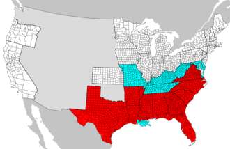


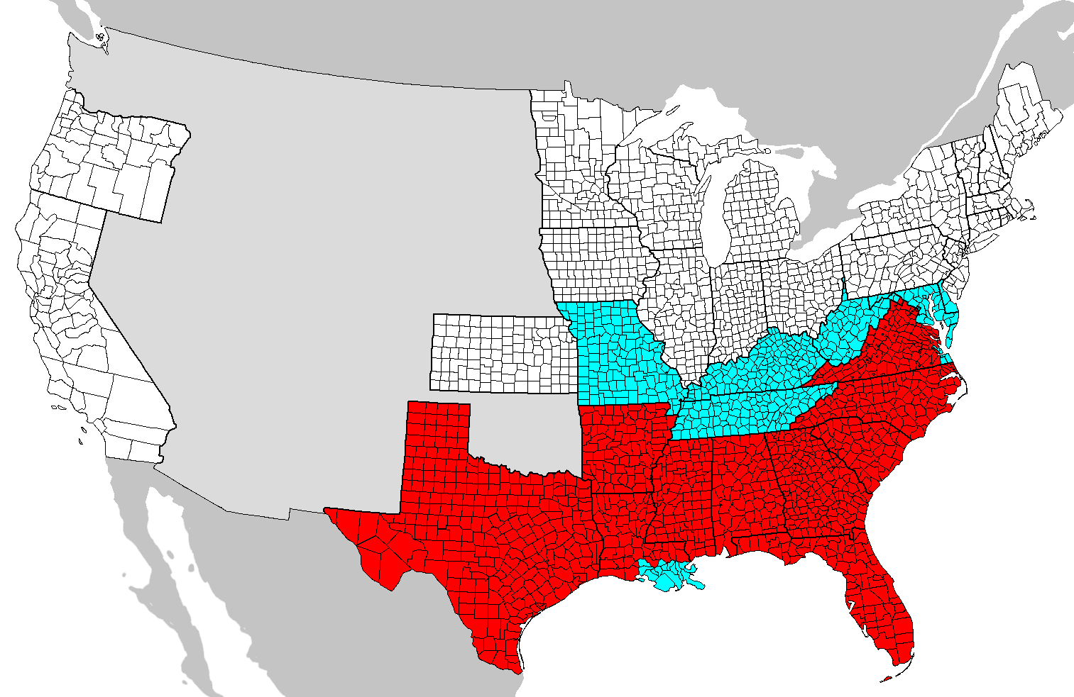
Wpdms arizona new mexico territories 1863 idx.png - Wars
Emancipation Proclamation.PNG - JasonAQuest

Map of the approaches to Little Rock 1863.jpg - PKM
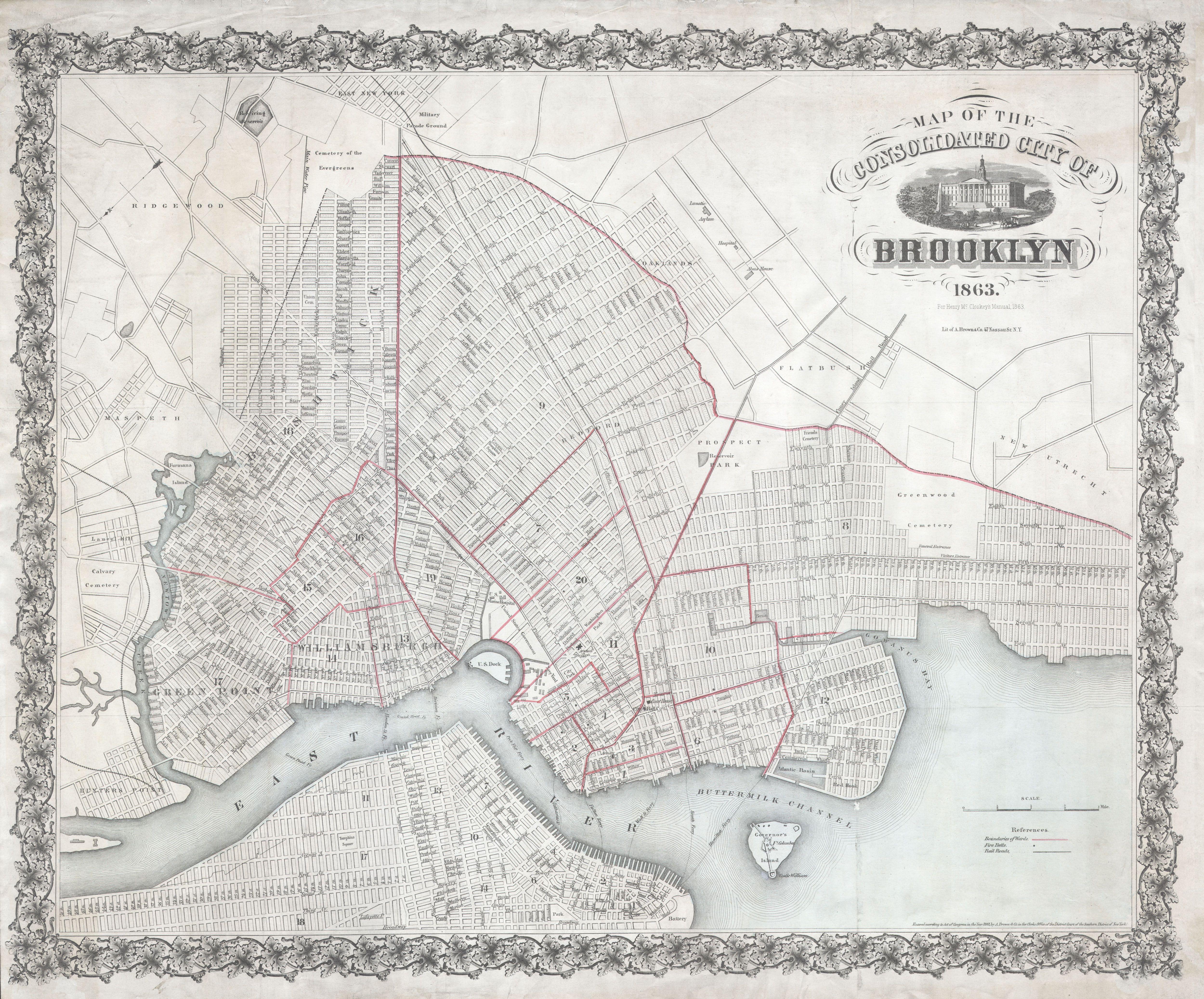
1863 McCloskey Pocket Map of Brooklyn, New York - Geographicus - Brooklyn-mccloskey-1863.jpg - BotMultichillT

1863 Fisk and Russell Map of New York City - Geographicus - NYC-fiskrussell-1863.jpg - BotMultichillT
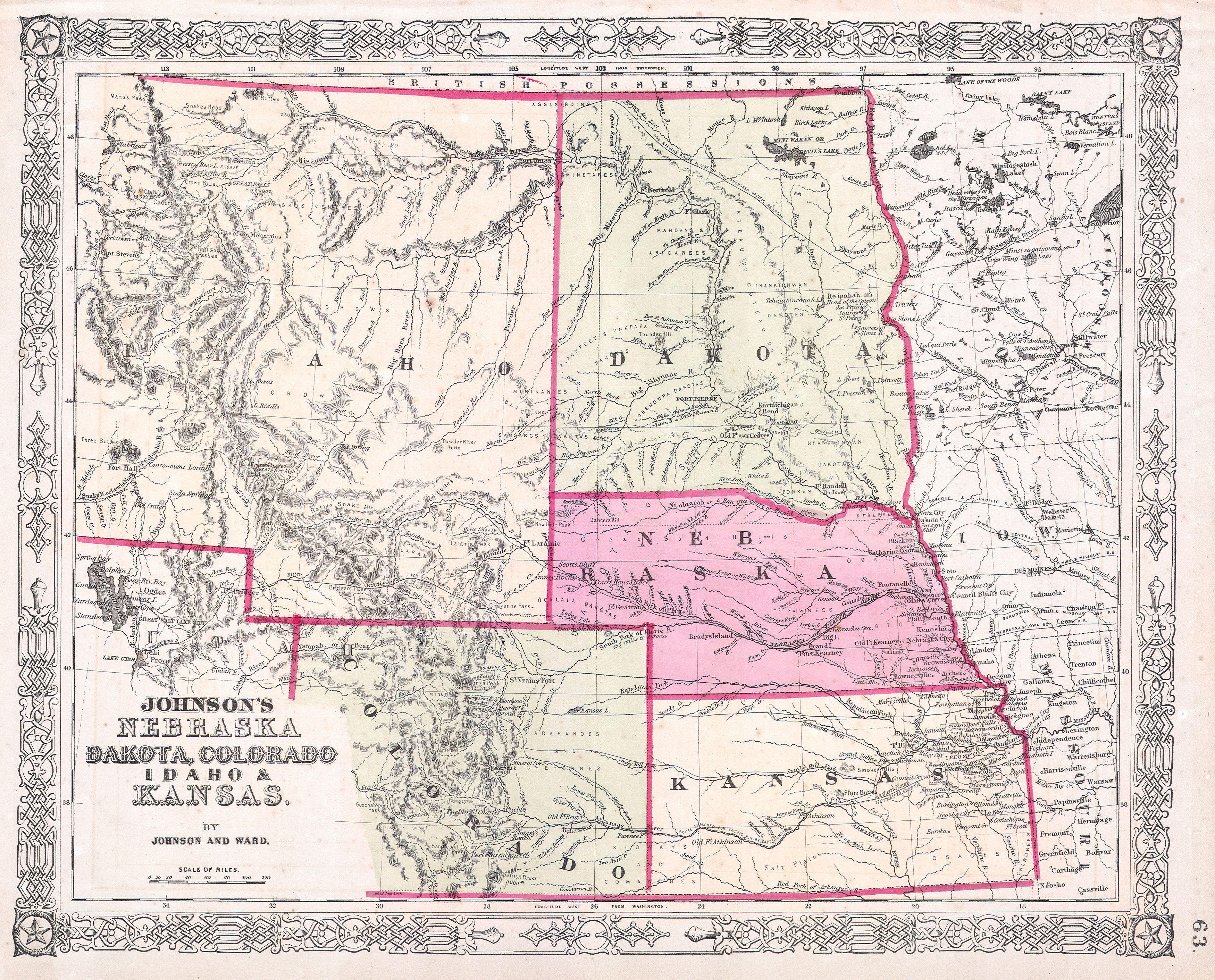
1863 Johnson's Map of Colorado, Dakota, Idaho, Nebraska ^ Kansas - Geographicus - COCANE-j-64.jpg - BotMultichillT
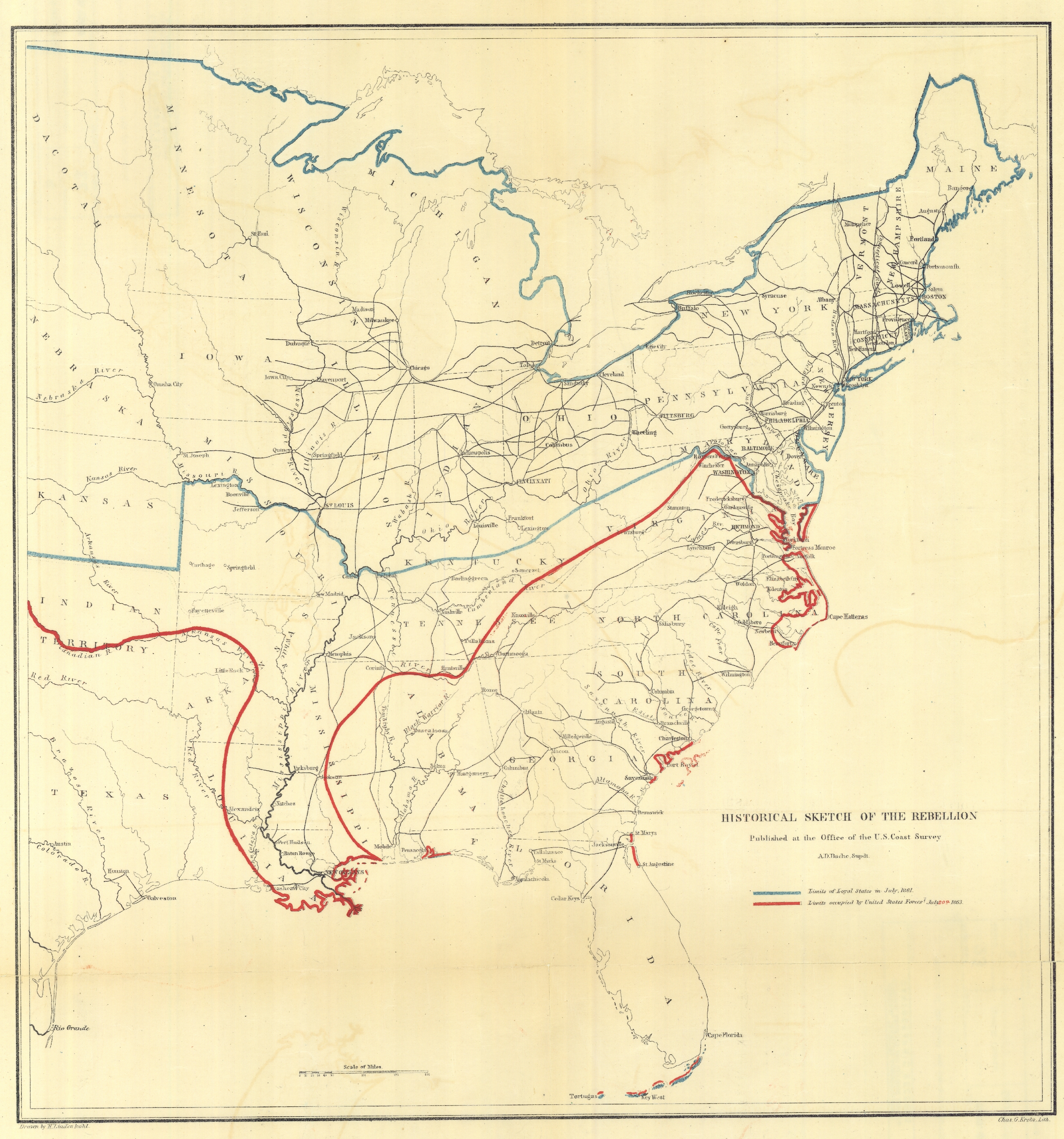
Historical Sketch of the Rebellion. Published at the Office of the U.S. Coast Survey, A. D. Bache, - NARA - 305697.tif - US National Archives bot
Texas Coast Showing Points of Occupation of Expedition Under Maj. Gen. N. P. Banks, Novr. 1863. - NARA - 305823.tif - US National Archives bot
Aransas Pass, Texas, Taken by the Union forces under Maj. Gen. Banks, Nov. 17th., 1863 . . . shows the position of... - NARA - 305796.tif - US National Archives bot

Atchafalaya Basin. Prepared by order of Maj. Gen. N. P. Banks. Henry L. Abbot, Capt. & Chief Top. Eng'rs., Feb.... - NARA - 305632.jpg - US National Archives bot
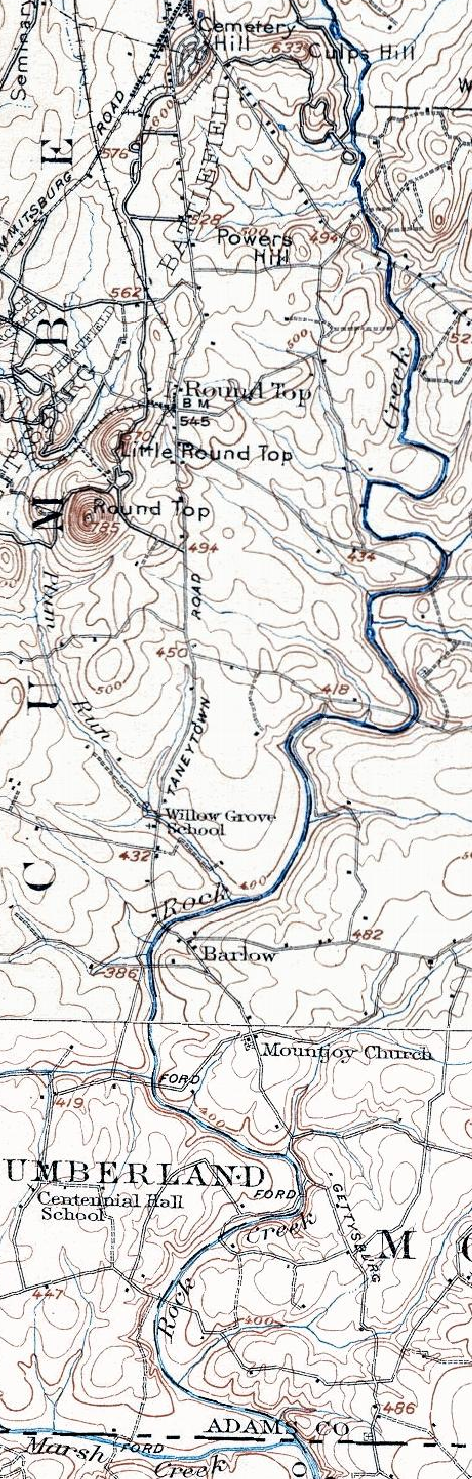
1907 Taneytown Road.png - Target for Today

Map of the United States of America, Mexico, Central America, and the West India Islands (9473843326).jpg - File Upload Bot (Magnus Manske)

Lloyds new county map of the United States and Canadas showing battle fields, railroads, &c., compiled from the latest goverment surveys & other reliable & official sources (9471060825).jpg - Taterian

G. Woolworth Coltons new guide map of the United States & Canada with railroads, counties etc. (7557435086).jpg - File Upload Bot (Magnus Manske)

Map of eastern Virginia (6094153798).jpg - File Upload Bot (Magnus Manske)

Map of the State of Virginia (5960840069).jpg - File Upload Bot (Magnus Manske)

Port Hudson and its defences (5961394512).jpg - File Upload Bot (Magnus Manske)

Map of Mobile showing the Rebel stronghold in the Gulf (5961390040).jpg - File Upload Bot (Magnus Manske)

Lloyds new map of the Mississippi River from Cairo to its mouth (5960828391).jpg - File Upload Bot (Magnus Manske)

Chart of the Mississippi River from the Ohio River to Gulf of Mexico (5961386478).jpg - File Upload Bot (Magnus Manske)

Parts of southern states bordering on Gulf of Mexico (5961386894).jpg - File Upload Bot (Magnus Manske)

Perrines new topographical war map of the southern states, taken from the latest government surveys and official reports (5961379196).jpg - File Upload Bot (Magnus Manske)

Reconnoissance of the Mississippi River below Forts Jackson and St. Philip, made previous to the reduction by the U.S. Fleet, under the command of flag officer D.G. Farragut, U.S.N. (5120567483).jpg - File Upload Bot (Magnus Manske)

Our Nations Heroes (5120566149).jpg - File Upload Bot (Magnus Manske)

Mississippi River near Vicksburg and vicinity (5121169712).jpg - File Upload Bot (Magnus Manske)

Map of the new convalescent camp, Fairfax Co., Va. four miles S.W. from Washington, D.C. (5120542269).jpg - File Upload Bot (Magnus Manske)

Map of military road from Fort Walla Walla on the Columbia to Fort Benton on the Missouri (3856251000).jpg - File Upload Bot (Magnus Manske)
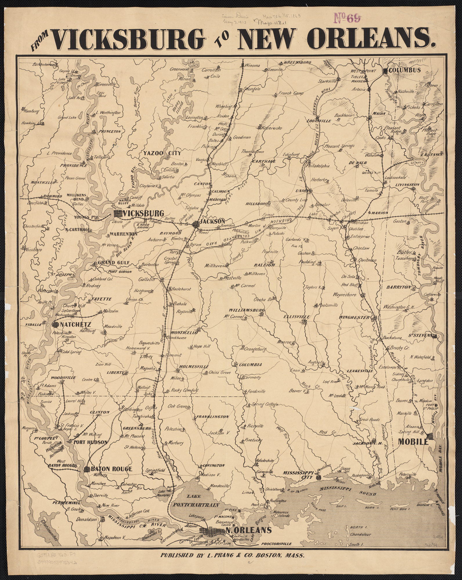
From Vicksburg to New Orleans (2674692374).jpg - File Upload Bot (Magnus Manske)

Map of a part of Louisiana and Mississippi, illustrating the operations of the U.S. (2674686724).jpg - File Upload Bot (Magnus Manske)

Map showing a battle ground at Kelly's Ford, Virginia, 17 March 1863.jpg - Taterian
Colton's new railroad & county map of the United States, the Canadas &c (NYPL b20643944-5578077).tiff - Fæ
Colton's new railroad & county map of the United States, the Canadas &c (NYPL b20643944-5578078).tiff - Fæ
Map of the United States, and territories. Together with Canada etc Hampton Roads and Norfolk Harbor (inset); Pensacola Bay (inset) (NYPL b13663520-1510796).tiff - Fæ

Colton's new railroad & county map of the United States, the Canadas &c (NYPL b20643944-5578076).jpg - Fæ

Map of the counties of Chenango and Cortland, New York - from actual surveys (10210935494).jpg - Fæ

Map showing location of the Chicago and Northwestern Railway with its branches and connections through Illinois, Iowa, Nebraska, Wisconsin, Minnesota, Michigan (10156901626).jpg - Fæ

Lloyd's railroad, telegraph and express map of the Eastern States to accompany Lloyd's railroad, telegraph and express map of the United States and Canadas (10210586474).jpg - Fæ

124 of 'A Chronological History of the Civil War in America, illustrated with A. I. Johnson's and I. H. Colton's Steelplate Maps and Plans of the Southern States and Harbors' (11064932006).jpg - Artix Kreiger 2

Cgs05247 (9716175077).jpg - Artix Kreiger 2

(Map of Catoosa County and parts of Whitfield, Murray, and Walker counties, Georgia) Chattanooga, Sept. 12 (1863?) LOC 2008628277.jpg - Fæ

Richmond and its defences. Constructed and engraved to illustrate "The war with the South" LOC 99439139.jpg - Fæ

Map showing the positions occupied by the Third Pennsylvania Cavalry in the engagements on the right flank at Gettysburg, Pa., between the Union cavalry under Gen. D. McM. Gregg and the "Stonewall" LOC 99439148.jpg - Fæ

Atlantic coast of the United States (in four sheets), sheet no. II, Nantucket to Cape Hatteras. LOC 99447131.jpg - Fæ

Plan of attack on Marie's Heights, Fredericksburg, Va. or 2nd Battle of Fredericksburg. By Maj. Genl. John Sedgwick with 6th Army Corps, Sunday, May 3rd, 1863. LOC gvhs01.vhs00022.jpg - Fæ

Additions & corrections for the "Map of a part of the Rappahannock above Fredericksburg" LOC 99448486.jpg - Fæ

Portions of the military departments of Virginia, Washington, Middle & the Susquehanna LOC 00552202.jpg - Fæ
Gulf coast of the United States; Key West to Rio Grande. LOC 99447136.tif - Fæ

Gulf coast of the United States; Key West to Rio Grande. LOC 99447136.jpg - Fæ

Gulf coast of the United States, Key West to Rio Grande. LOC 99447137.jpg - Fæ

Johnson's new illustrated (steel plate) family atlas, with descriptions, geographical, statistical, and historical LOC 2006458040.jpg - Fæ

Sketch of rebel fortifications at Hayne's Bluff. LOC 99447416.jpg - Fæ

Map of the Rappahannock River fron (sic) Port Royal to Richards Ferry LOC 2003630517.jpg - Fæ

J. H. Colton's map of the southern states. Maryland, Delaware, Virginia, Kentucky, Tennessee, Missouri, North Carolina, South Carolina, Georgia, Alabama, Mississippi, Arkansas, Louisiana and Texas. LOC 99447109.jpg - Fæ

Route of the Tenth New York Cavalry from Culpeper to Gettysburg and return. Summer and fall campaigns of 1863. LOC 99446355.jpg - Fæ

Portions of the military departments of Virginia, Washington, Middle & the Susquehanna, LOC 99447129.jpg - Fæ

Bacon's steel plate map of America, political, historical & military. LOC 99447105.jpg - Fæ

New map of Charleston Harbor, showing the scene of the great naval contest between the iron clad monitors and the Rebel batteries, also the lines of fire, forts, obstructions, inlets, princl. LOC 99448820.jpg - Fæ

The Battlefield of Chicamauga Fought the 19th and 20th of Septr 1863. LOC gvhs01.vhs00315.jpg - Fæ

New Orleans to Vicksburg LOC 86691588.jpg - Fæ

Genl. Thomas' new position 20th Septr. 3 p.m. LOC gvhs01.vhs00159.jpg - Fæ

Plan of battles of Kelly's Ford and Rappahannock Station, Virginia - both fought Novr. 7th, 1863. LOC gvhs01.vhs00302.jpg - Fæ

Portions of the military departments of Virginia, Washington, Middle & the Susquehanna, LOC 99447130.jpg - Fæ

Map of the country between the York and James Rivers in 1862 and 1863 - showing the names of the owners of the divisions of land at that time. LOC lva0000180.jpg - Fæ

Approaches to Fort Butte La Rose, Louisiana, LOC 99447199.jpg - Fæ

Map of Morris, Folly, Coles and James Island(s) etc., and Charleston Harbor S.C. shewing (sic) Union and Rebel forts and batteries, 1864. LOC gvhs01.vhs00184.jpg - Fæ

Position of Union and Rebel forces, Oct. 14, 1863 LOC gvhs01.vhs00164.jpg - Fæ

W. Alvin Lloyd's southern rail-road map, 1863 LOC lva0000025.jpg - Fæ

Perrine's new topographical war map of the southern states LOC 99447122.jpg - Fæ

J. H. Colton's topographical map of the seat of war in Virginia, Maryland etc. LOC 99448508.jpg - Fæ

Atlantic coast of the United States (in four sheets) - sheet no. III, Cape Hatteras to Mosquito Inlet. LOC 2008627953.jpg - Fæ

Mountain region of North Carolina and Tennessee LOC 99447120.jpg - Fæ

Bacon's topographical map of the seat of war in Virginia, Maryland and Pennsylvania LOC lva0000028.jpg - Fæ

Map of the field of operations, November 1863. LOC gvhs01.vhs00172.jpg - Fæ

Map of a part of Louisiana and Mississippi, illustrating the operations of the U.S. Forces in the Department of the Gulf LOC 86691328.jpg - Fæ

Map showing route taken by Mosby with his prisoners, Nov. 27th-29th, 1863. LOC gvhs01.vhs00175.jpg - Fæ

Hazard's rail road & military map of the southern states. LOC 00552203.jpg - Fæ

Route of 3rd Corps from Cattlet's (sic) to Greenwich, Va. LOC gvhs01.vhs00163.jpg - Fæ

Map showing the routes of Brig. Gen. J.B. (i.e., J.D.) Imboden's command during the Pennsylvania campaign of 1863 LOC 2005625068.jpg - Fæ
Seat of war in America, 6d. LOC 85690962.tif - Fæ

Chart of the Mississippi River from the Ohio River to Gulf of Mexico LOC 99447139.jpg - Fæ

Plan of attack on Marie's Heights, Fredericksburg Va. By Maj. Genl. John Sedgwick, USA, with the 6th Army Corps. Sunday May 3rd 1863. LOC gvhs01.vhs00222.jpg - Fæ

Atlantic coast of the United States (in four sheets) - sheet no. IV, Mosquito Inlet to Key West. LOC 2008627954.jpg - Fæ

Monitor map, showing the whole seacoast from Chesapeake Bay, down to Savannah harbor, and the whole country between Richmond & Savannah, with map on large scale of the harbor of Charleston. LOC 99447127.jpg - Fæ

Map of Charleston Harbor showing Union and Rebel Batteries etc. Septr. 1863. LOC gvhs01.vhs00153.jpg - Fæ

Map of the lower (Shenandoah) Valley LOC 2005625051.jpg - Fæ

Plan of the Battle of Bristoe Station, Orange and Alexandria Railroad, Va., Octr. 14th 1863. LOC gvhs01.vhs00219.jpg - Fæ

Map shewing (sic) movements of Union and Rebel armies from 30th June to 13th July 1863. LOC gvhs01.vhs00047.jpg - Fæ

Lloyd's new county map of the United States and Canadas showing battle fields, railroads, etc., compiled from the latest government surveys & other reliable & official sources, drawn and engraved by LOC 98688333.jpg - Fæ

Map of a part of Louisiana and Mississippi - illustrating the operations of the U.S. Forces in the Department of the Gulf LOC 86691336.jpg - Fæ

Lloyd's map of the southern states showing all the railroads, their stations & distances, also the counties, towns, villages, harbors, rivers, and forts LOC 99447115.jpg - Fæ

The battle fields and military positions in eastern Virginia, from surveys supplied by officers of the army LOC 99448510.jpg - Fæ

(Map of Culpeper County and parts of the counties of Warren, Rappahannock, Madison, Orange, and Fauquier) LOC 99439165.jpg - Fæ

Fisheye view of Chattanooga and vicinity showing troop positions in 1863. LOC 99448455.jpg - Fæ

Atlantic coast of the United States (in four sheets) - sheet no. II, Nantucket to Cape Hatteras. LOC 2008627951.jpg - Fæ
Map of the battle of Chancellorsville, including operations from April 29th to May 5th, 1863. LOC gvhs01.vhs00037.tif - Fæ

Map of the battle of Chancellorsville, including operations from April 29th to May 5th, 1863. LOC gvhs01.vhs00037.jpg - Fæ
Mountain region of North Carolina and Tennessee LOC 79696027.tif - Fæ

Map of field of occupation of Army of the Potomac LOC 99446529.jpg - Fæ

Lloyd's new military map of the border & southern states LOC 99447111.jpg - Fæ

Map of the cost (sic) of Georgia & Florida. LOC 79695217.jpg - Fæ
Map shewing (sic) movements of army from 30th June to 1st July 1863 - and first encounter of 1st Corps with the enemy. LOC gvhs01.vhs00144.tif - Fæ

Fortifications around Charleston, H.B. ... LOC lva0000154.jpg - Fæ

(Map of Arkansas Post, Ark.) LOC 2006635252.jpg - Fæ

Atlantic coast of the United States (in four sheets) - sheet no. IV, Mosquito Inlet to Key West. LOC 2008628432.jpg - Fæ

Atlantic coast of the United States (in four sheets) - sheet no. III, Cape Hatteras to Mosquito Inlet. LOC 2008628431.jpg - Fæ

Memoranda of J. Hotchkiss, Top. Eng., Hd. Qrs., 2nd Corps, A.N.Va. - (Chancellorsville, Virginia). LOC 2005625049.jpg - Fæ

Phelps and Watson's historical and military map of the border & southern states. LOC 99447124.jpg - Fæ

Military map, Baltimore Co., Md. LOC 99447398.jpg - Fæ

Map showing the positions occupied by the Tenth New York Cavalry in the cavalry engagements on the right flank at Gettysburg, Penn. - on July 2 & 3, 1863, between the Union cavalry under Gen. D. McM. LOC 2007630415.jpg - Fæ
Cgs05255 (9716190703).jpg - MarginalCost

Pencil sketches of Confederate troop positions along the Furnace Road south of Chancellorsville, on the "night of May 1st" and "May 2nd" 1863. LOC 2005625037.jpg - Fæ

Map of Erie & part of Ottowa Counties, Ohio - showing the sections, farms, lots and villages LOC 2012592231.jpg - Fæ

The historical war map. LOC 99447068.jpg - Fæ

Military map of the vicinity of Frankfort, Kentucky LOC 86691123.jpg - Fæ

Map of the southern states, including rail roads, county towns, state capitals, count roads, the southern coast from Delaware to Texas, showing the harbors, inlets, forts and position of blockading LOC 99447106.jpg - Fæ

Map of Surry, Sussex and Southampton counties, Virginia. LOC gvhs01.vhs00380.jpg - Fæ

Coast of North Carolina & Virginia LOC 99447450.jpg - Fæ

Map of the territory of the United States from the Mississippi River to the Pacific Ocean; ordered by Jeff' Davis, Secretary of War to accompany the reports of the explorations for a railroad route. LOC gm71000831.jpg - Fæ
Map of a part of Louisiana and Mississippi, illustrating the operations of the U.S. forces, in the Department of the Gulf LOC 99447189.tif - Fæ

Atlantic coast of the United States (in four sheets) - sheet no. IV, Mosquito Inlet to Key West. LOC 2008628433.jpg - Fæ

Bristoe Campaign LOC gvhs01.vhs00392.jpg - Fæ

Military map, Baltimore Co., Md. LOC 99447398 (cropped).jpg - Sauzer

Lake de Flambeau Indian Reservation Boundary - NARA - 84786062.jpg - US National Archives bot

Admiralty chart No 485 Santa Cruz Surveyed by Mr. John Parsons, Master, R.N. 1856 (with early annotations!), Published 1858, Corrections to 1863.jpg - Balkanique

Map of the United States - DPLA - 5f03bf3bb6db46ed511f436337daebff.jpg - DPLA bot

Manuscript map of Chattanooga made in 1863 - Cgs05240.jpg - Ooligan

Sketch of rebel fortifications at Hayne's Bluff. LOC 99447416 (cropped).jpg - SteinsplitterBot
Colton's new railroad & county map of the United States, the Canadas &c (NYPL b20643944-5578076).tiff - Fæ