Wikimedi'Òc
Modes d'emploi

Cet album fait partie des albums
Cet album photos contient les sous-albums suivants :


1865 Johnson Map of Washington, Oregon ^ Minnesota - Geographicus - WAORMN-j-65.jpg - BotMultichill

1867 Mitchell Map of Oregon, Washington, Idaho and Montana - Geographicus - WAORIDMT-mitchell-1867.jpg - BotMultichillT

1866 Colton Map of Oregon, Washington, Idaho and Montana (w- Wyoming) - Geographicus - WAORIDMT-colton-1866.jpg - BotMultichillT

1862 Johnson Map of Washington and Oregon w-Idaho - Geographicus - WAOR-johnson-1862.jpg - BotMultichillT

1866 Mitchell Map of Washington, Oregon, Idaho and Montana - Geographicus - WashingtonOregonIdaho-mitchell-1866.jpg - BotMultichillT
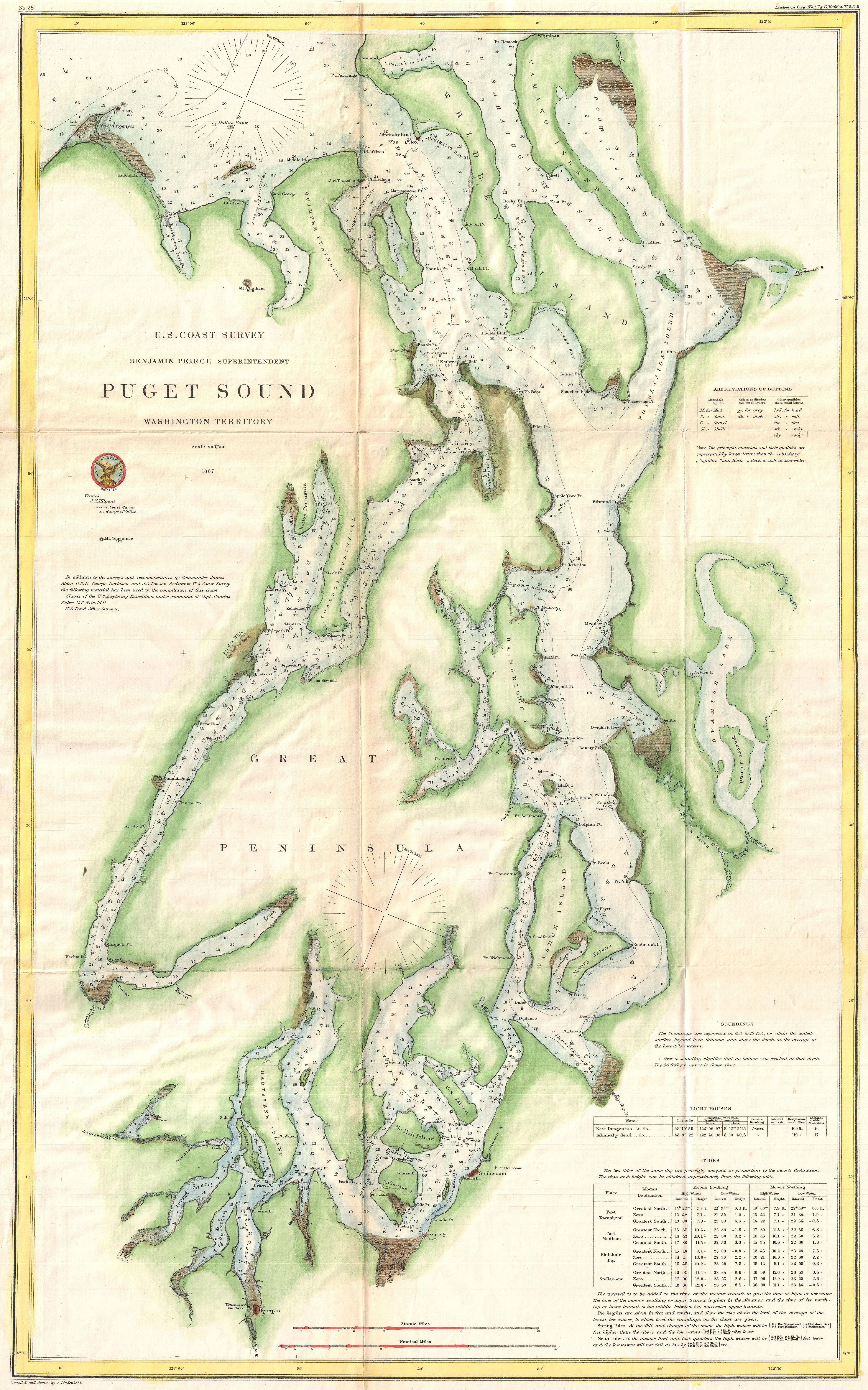
1867 U.S. Coast Survey Chart or Map of Puget Sound, Washington - Geographicus - PugetSound-uscs-1867.jpg - BotMultichillT

1864 Johnson Map of Washington, Oregon, and Idaho - Geographicus - OregonWashingtonIdaho-johnson-1864.jpg - BotMultichillT

27 of 'Partisan Life with Col. J. S. Mosby ... With portraits and engravings on wood' (11082166794).jpg - Artix Kreiger 2

Where to emigrate and why - describe the climate-soil-productions-minerals and general resources-amount of public lands-the quality and price of farm lands in nearly all sections of the United States; (14571723979).jpg - SteinsplitterBot

Map of public surveys in the territory of Washington. LOC 98687151.jpg - Fæ

1863 Johnson Map of Delaware and Maryland - Geographicus - MDDE-j-63.jpg - BotMultichill

Map of South East End of San Juan Island, Washington Territory, Showing Government Reservations - NARA - 100305680.jpg - US National Archives bot

Map of an Indian Reservation near the Pacific Ocean in Washington Territory - DPLA - 0ace36d63c6fa7010bbe4380c2337c94.jpg - DPLA bot

Duwamish River 1862.jpg - AdJHu

Duwamish River 1862 (cropped).jpg - AdJHu