Wikimedi'Òc
Modes d'emploi

Cet album fait partie des albums
Cet album photos contient les sous-albums suivants :


United States 1836-03-1836-06.png - Golbez
United States 1836-06-1836-07.png - Golbez

United States 1836-07-1837-01.png - Golbez
Map albert gallatin 1836.jpg - DemonDeLuxe
Map of Indian territory 1836.png - Ww2censor

1836 Michigan.jpg - Flickr upload bot
The tourist's pocket map of the state of Virginia - exhibiting its internal improvements, roads, distances, etc - by J.H. Young; engraved by E. Yeager and F. Dankworth. NYPL434090.tiff - Fæ
The travellers guide, or, Map of the roads, canals and rail roads of the United States, with the distances from place to place - by H.S. Tanner. NYPL434057.tiff - Enyavar
The tourist's guide through the states of Maryland, Delaware, and parts of Pennsylvania and Virginia - with the routes to their springs, etc - drawn and published by F. Lucas Jr.; engraved by NYPL433935.tiff - Fæ

Mitchell's traveller's guide through the United States - containing the principal cities, towns, &c., alphabetically arranged, together with the stage, steam-boat, canal, and railroad routes, with the (14759034364).jpg - Fæ

Map of the United States (NYPL b14978525-434646).jpg - Fæ

Map of the United States (NYPL b14978525-1254624).jpg - Fæ

The states of Ohio, Indiana & Illinois and Michigan Territory (NYPL b20643882-5437621).jpg - Fæ

Long Island 1836 map.jpg - Ratzer

12 of 'Atlas' (11013309386).jpg - Artix Kreiger 2

20 of 'Atlas' (11012693753).jpg - Artix Kreiger 2

13 of 'Atlas' (11012139674).jpg - Artix Kreiger 2
Map of Dexter in Jefferson County N.Y. LOC 2007625484.tif - Fæ

Map of Dexter in Jefferson County N.Y. LOC 2007625484.jpg - Fæ
Map of valuable property in the 6th ward of the city of Brooklyn belonging to John Dikeman & others to be sold by Franklin & Jenkins on Monday, 29th August, 1836 at 12 o'colck at their sales room, 15 LOC 78692675.tif - Fæ

Map of valuable property in the 6th ward of the city of Brooklyn belonging to John Dikeman & others to be sold by Franklin & Jenkins on Monday, 29th August, 1836 at 12 o'colck at their sales room, 15 LOC 78692675.jpg - Fæ

The states of Ohio, Indiana & Illinois and Michigan Territory - from the latest authorities. LOC 2012593319.jpg - Fæ
Mitchell's map of the United States - showing the principal travelling turnpike and common roads, on which are given the distances in miles from one place to another, also the courses of the canals & LOC 87692342.tif - Fæ

Mitchell's map of the United States - showing the principal travelling turnpike and common roads, on which are given the distances in miles from one place to another, also the courses of the canals & LOC 87692342.jpg - Fæ
Partial cadastral map of the district around the Center Market, N.W. Washington D.C.. LOC 88694081.tif - Fæ

Partial cadastral map of the district around the Center Market, N.W. Washington D.C.. LOC 88694081.jpg - Fæ
Map of the city of New Brunswick, New Jersey LOC 2012585908.tif - Fæ

Map of the city of New Brunswick, New Jersey LOC 2012585908.jpg - Fæ
Map of Irving, situated in Westchester Co., state of New-York LOC 91683241.tif - Fæ

Map of Irving, situated in Westchester Co., state of New-York LOC 91683241.jpg - Fæ
Map showing the most direct commercial route from the Atlantic via L. Ontario, to the province of Upper Canada, the north western states & territories, and to the Mississippi. LOC 98688349.tif - Fæ

Map showing the most direct commercial route from the Atlantic via L. Ontario, to the province of Upper Canada, the north western states & territories, and to the Mississippi. LOC 98688349.jpg - Fæ
Map of the city of Perth Amboy, N.J. - February 1836 LOC 2006625921.tif - Fæ

Map of the city of Perth Amboy, N.J. - February 1836 LOC 2006625921.jpg - Fæ
The tourist's guide through the States of Maryland, Delaware, and parts of Pennsylvania & Virginia - with the routes to their springs, etc. LOC 83694375.tif - Fæ

The tourist's guide through the States of Maryland, Delaware, and parts of Pennsylvania & Virginia - with the routes to their springs, etc. LOC 83694375.jpg - Fæ
Carte des États-unis d'Amérique. LOC gm70002851.tif - Fæ

Carte des États-unis d'Amérique. LOC gm70002851.jpg - Fæ
Map of Newark and East Newark, N.J. from the most authentic surveys. LOC gm71002268.tif - Fæ

Map of Newark and East Newark, N.J. from the most authentic surveys. LOC gm71002268.jpg - Fæ
Map of the village of Highgate, Franklin County, state of Vermont LOC 2008624023.tif - Fæ

Map of the village of Highgate, Franklin County, state of Vermont LOC 2008624023.jpg - Fæ
The tourist's guide through the states of Maryland, Delaware and part of Pennysylvania & Virginia with the routes to their springs etc. LOC 98688344.tif - Fæ

The tourist's guide through the states of Maryland, Delaware and part of Pennysylvania & Virginia with the routes to their springs etc. LOC 98688344.jpg - Fæ
Map showing the lands assigned to emigrant Indians west of Arkansas and Missouri. LOC 99446197.tif - Fæ

Map showing the lands assigned to emigrant Indians west of Arkansas and Missouri. LOC 99446197.jpg - Fæ

800-c-Reg4-B-1836b.jpg - Wildiewill
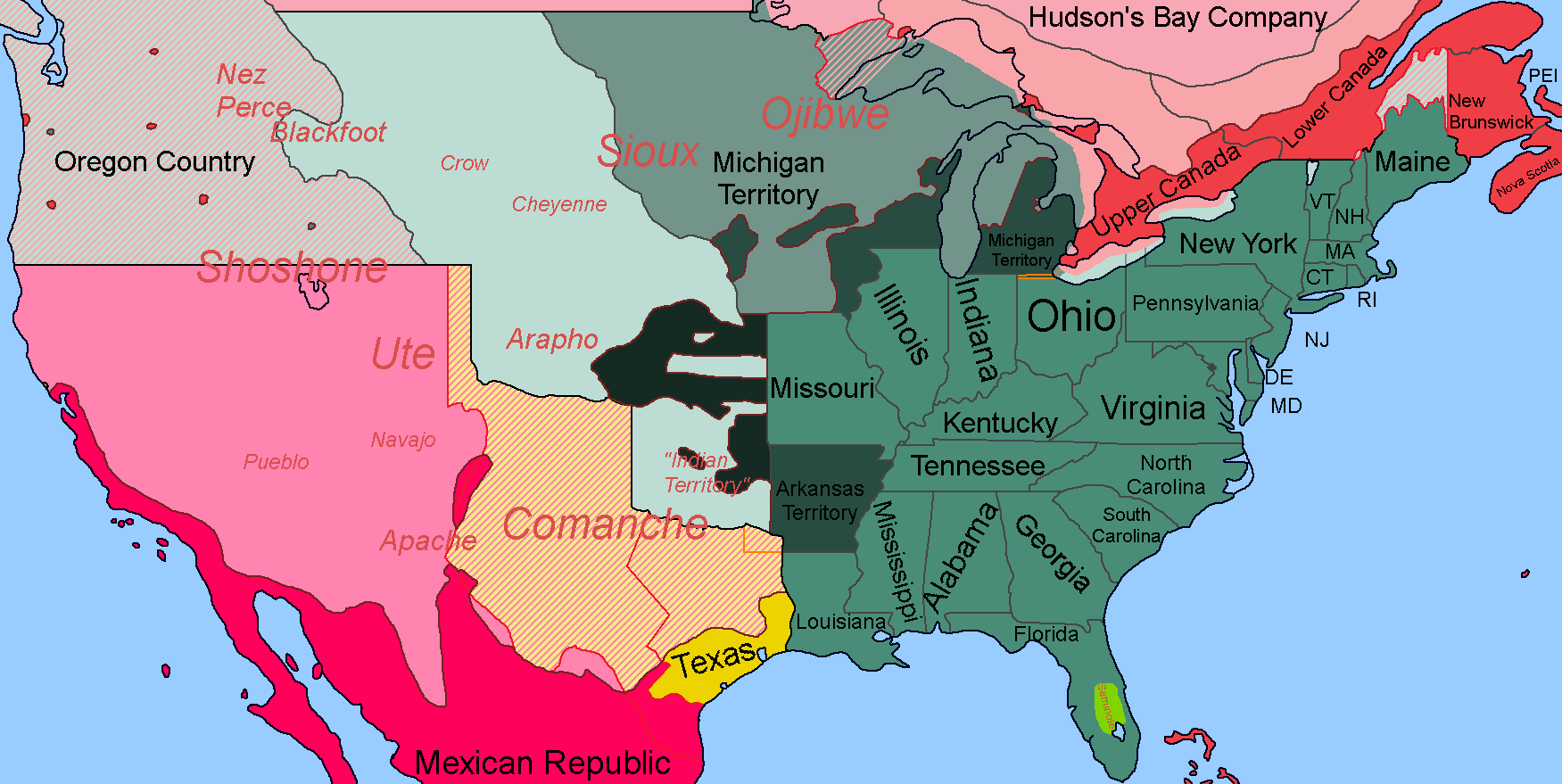
USA 1836 With Native Controlled Lands and Labels.png - RickoTroanman22

Menominee land cession of 1836.png - Jeff the quiet