Wikimedi'Òc
Modes d'emploi

Cet album fait partie des albums
Cet album photos contient les sous-albums suivants :


First Nation Control over North America about 1600 AD.jpg - Esemono
Upravni zemljevid Kranjske leta 1836.jpg - Sporti

1836 Cary Map of Greece and the Balkans - Geographicus - TurkeyinEurope-cary-1836.jpg - BotMultichill
1836 Malte-brun Map of Russia in Asia and Siberia - Geographicus - Siberie-mb-1836.jpg - BotMultichill

1836 Andriveau Goujon Comparative Mountains and Rivers Chart - Geographicus - MountainsRivers-andriveau-1836.jpg - BotMultichillT
A map of Illinois, 1836 - NARA - 306590.tif - US National Archives bot

Dublin 1836.jpg - National Public Domain Archive

1836 Eastern Railroad plan.jpg - Pi.1415926535

Plan of Winnisimmet, in Chelsea (6093626163).jpg - File Upload Bot (Magnus Manske)

Königreich Illyrien, Gouvernement Laibach Charte der Kreise 1836.jpg - Sporti
British possessions in North America - drawn and engraved by J. & C. Walker. NYPL433892.tiff - Fæ
Chart of the mouth of Susquehanna River and head waters of Chesapeake Bay, Maryland - surveyed by order of Congress, under the direction of G.W. Hughes, U.S. Civil Engineer, by T.J. Lee and C.N. NYPL433939.tiff - Finavon
Chart of the mouth of Susquehanna River and head waters of Chesapeake Bay, Maryland - surveyed by order of Congress, under the direction of G.W. Hughes, U.S. Civil Engineer, by T.J. Lee and C.N. NYPL478073.tiff - Fæ
Topographical map of the city and county of New-York, and the adjacent country - with views in the border of the principal buildings, and interesting scenery of the island. NYPL434687.tiff - Fæ

BOELEN(1836) T3 p042 KAART VAN DE SANDWICH EILANDEN.jpg - Metilsteiner

BOELEN(1836) T3 p286 SCHETS VAN DE HAVEN VAN MACAO.jpg - Metilsteiner

AMH-5541-NA Map of the south eastern islands.jpg - HuskyBot

Tours cadastre napoléonien amphi.jpg - Arcyon37

Carte routière du département de l'Aude.jpg - Gz260

Département de la Moselle - 1836.jpg - Gz260

Carte de l'arrondissement d'Avesnes - 1836.jpg - Gz260

Willem Cornelis van Baarsel and Petrus Nicolai Tuyn - Nieuwe Kaart van Haarlems Schoone Omstreken - 1836.jpg - Jane023
T24-li.jpg - Sanjayshivesh
T25-li.jpg - Sanjayshivesh

T44-li.jpg - Sanjayshivesh

T45-1-li.jpg - Sanjayshivesh

T72 (Bis).jpg - Sanjayshivesh

T7-3.jpg - Sanjayshivesh

T11-2.jpg - Sanjayshivesh

T10-ny.jpg - Sanjayshivesh
Carta particolare della nuoua Belgia è parte della nuoua Anglia (NYPL b20644060-5831483).tiff - Fæ

Carta particolare della nuoua Belgia è parte della nuoua Anglia (NYPL b20644060-5831483).jpg - Fæ

A plat of lands belonging to the Company of Grocers (27114684914).jpg - Fæ

A Plat of the towne of Colerane as it now stands built and fortifd (27449185330).jpg - Fæ

Charte der Landdrostei Hildesheim (Hildesheim).jpg - Wilkosense
South Australia. A survey of the coast on the east side of St. Vincents Gulf made by Colonel Light, Surveyor General. RMG F0362.tiff - Fæ
Chart of the Red Sea, comprising the part above Jiddah, on Mercator's projection, compiled from a stasimetric survey, executed in the years 1830, 31, 32 and 33 in the Honble. Compy's. ship Palinurus, by Comder. R. Moresby, RMG F0111.tiff - Fæ

Pianosa map 1836 by Attilio Zuccagni-Orlandini.jpg - Ratzer

Doubrava SK 1836.jpg - Gampe
A map of part of Alabama & Florida, showing the route of the proposed Columbus & Pensacola Rail Road, accompanying the report of Major J. D. Graham, U.S. Topographical Engr. Feb. 6th, 1836; drawn LOC 98688639.tif - Fæ

A map of part of Alabama & Florida, showing the route of the proposed Columbus & Pensacola Rail Road, accompanying the report of Major J. D. Graham, U.S. Topographical Engr. Feb. 6th, 1836; drawn LOC 98688639.jpg - Fæ

Topographical map of the city and county of New-York, and the adjacent country - with views in the border of the principal buildings, and interesting scenery of the island. LOC 2007627512.jpg - Fæ

A map of a portion of the Indian country lying east and west of the Mississippi River to the forty sixth degree of north latitude from personal observation made in the autumn of 1835 and recent LOC 96683128.jpg - Fæ

City of Washington. LOC 88694080.jpg - Fæ

1836 Limburg a. d. Lenne.jpg - Bärwinkel,Klaus

Map of Tibet and Lhasa (Lassa) in 1837 from Malte-Brun Map of China and Japan (cropped).jpg - Tibet Nation

Royal Commission on Metropolitan Termini Map.jpg - DavidCane
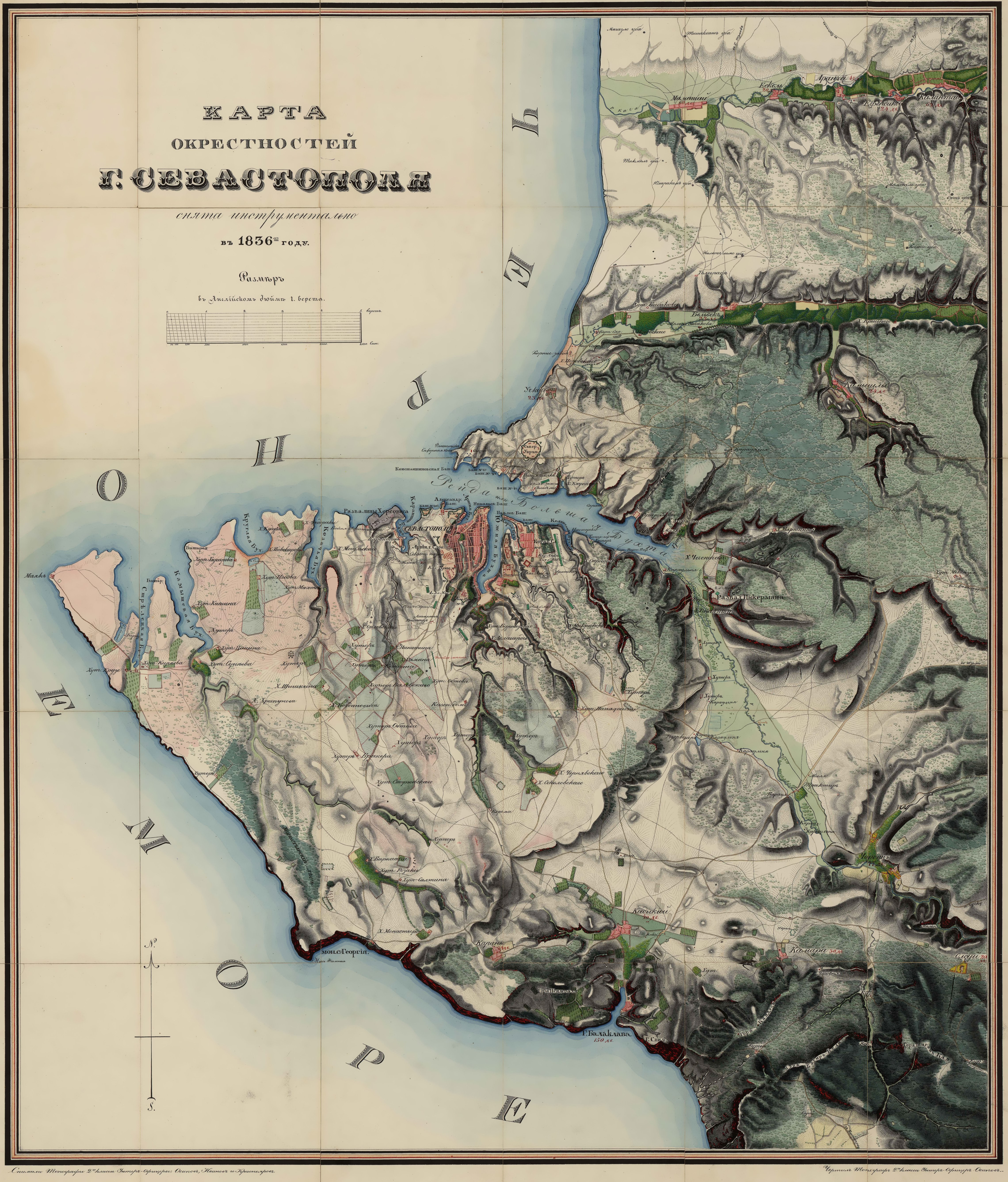
Россия. Крым. Карта окрестностей Севастополя, 1836г MapSev e1cr.jpg - T3ru

1837 Malte-Brun Map of India, Burma and Southeast Asia (Disapperance of Champa).png - Laska666

Bielsko Miasto - Bielitz Stadt mapa katastralna 1836 ze zmianami około 1885.jpg - Gaj777
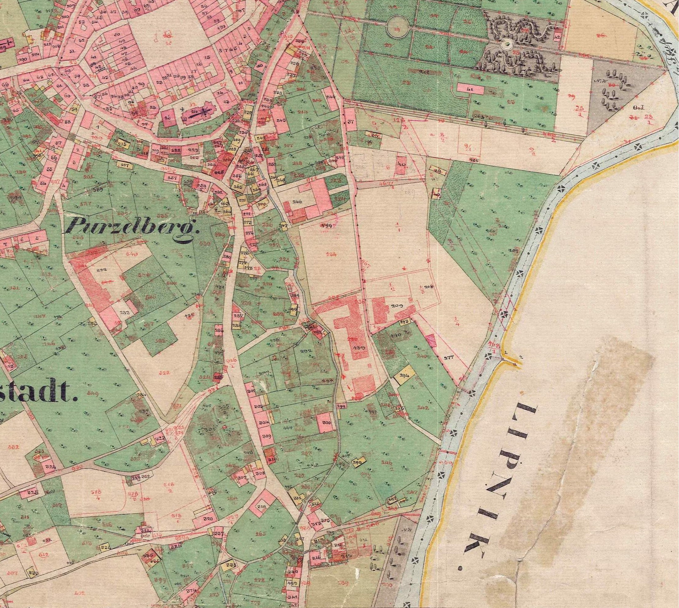
Bielsko Żywieckie Przedmieście - Bielitz Saybuscher Vorstadt mapa katastralna 1836 ze zmianami około 1885.jpg - Gaj777

Bielitz Niederring - Bielsko Plac Smolki mapa katastralna 1836 ze zmianami około 1885.jpeg - Gaj777

The countries of the ancient world exhibiting the probable settlement of the descendants of Noah (FL50795188 2368977).jpg - Geagea

Auguste Toussaint, Carte de la Terre Sainte ou de la Palestine (FL199992259 2369089).jpg - Geagea

אהרן בן חיים מהורדנה, המסעות וגבולי ארץ צבי והכרמל לפי רשי (FL199992243 2369223).jpg - Geagea

Society for the Diffusion of Useful Knowledge, Moscow (FL167448493 2369995).jpg - Geagea

Jerusalem and places adjacent (FL173354384 2502736).jpg - Geagea

Sidney Hall, Map of the countries north east of Palestine (FL6879988 2509087).jpg - Geagea

Félix Delamarche, Judée divisée en ses douze Tribus sous Josué (FL37129668 3911658).jpg - Geagea