Wikimedi'Òc
Modes d'emploi

Cet album fait partie des albums
Cet album photos contient les sous-albums suivants :


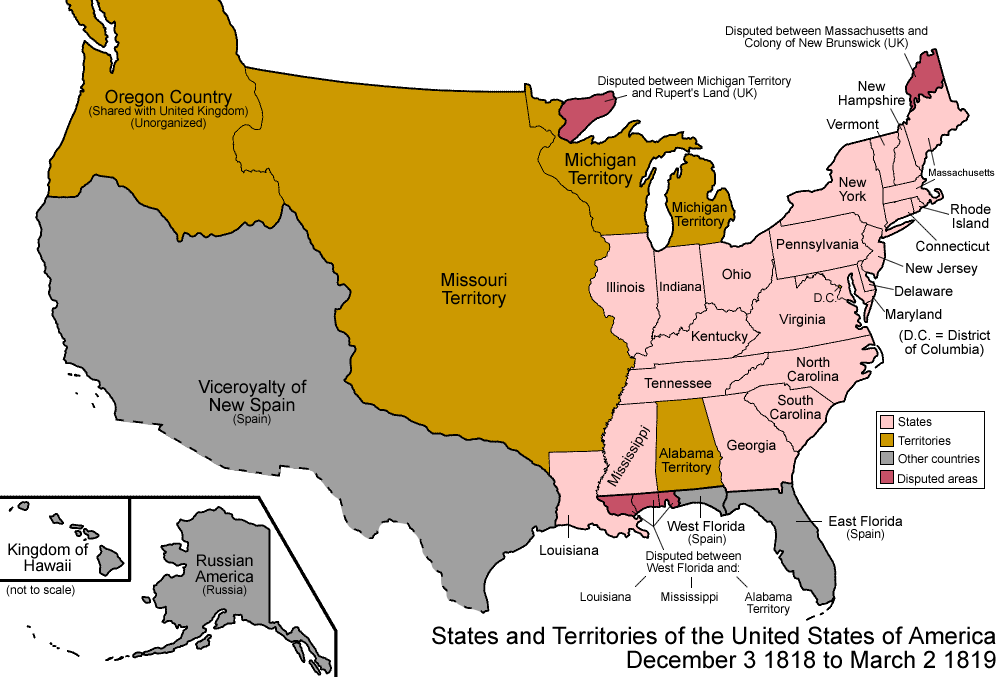
United States 1818-12-1819-03.png - Golbez

United States 1819-03-1819-12.png - Golbez

Viceroyalty of the New Spain 1819 (without Philippines).png - Giggette
Virginia - discovered and described by Captayn John Smith, 1606. NYPL434430.tiff - Fæ

The American journal of science, and c (1819) (14778882075).jpg - SteinsplitterBot
A map of Mexico, Louisiana, and the Missouri territory (NYPL b20643846-5404025).tiff - Fæ
A map of Mexico, Louisiana, and the Missouri territory (NYPL b20643846-5404026).tiff - Fæ
A map of Mexico, Louisiana, and the Missouri territory (NYPL b20643846-5404027).tiff - Fæ
A map of Mexico, Louisiana, and the Missouri territory (NYPL b20643846-5404028).tiff - Fæ

A map of Mexico, Louisiana, and the Missouri territory (NYPL b20643846-5404025).jpg - Fæ

Map of the United States of America - with the contiguous British and Spanish possessions LOC 96686680.jpg - Fæ

Plan of the city of Washington and territory of Columbia - engraved by W. & D. Lizars, Edin'r. LOC 91686245.jpg - Fæ
Map of the southern part of the state of New York including Long Island, the Sound, the state of Connecticut, part of the state of New Jersey, and islands adjacent - compiled from actual late surveys LOC 97683280.tif - Fæ

Map of the southern part of the state of New York including Long Island, the Sound, the state of Connecticut, part of the state of New Jersey, and islands adjacent - compiled from actual late surveys LOC 97683280.jpg - Fæ
(Map of the United States) LOC 2015591090.tif - Fæ

(Map of the United States) LOC 2015591090.jpg - Fæ
A Map-sketch of the United States of America. LOC 98685572.tif - Fæ

A Map-sketch of the United States of America. LOC 98685572.jpg - Fæ
Plat of that part of the Washington & Rockville Turnpike Road lying within the District of Columbia LOC 88693185.tif - Fæ

Plat of that part of the Washington & Rockville Turnpike Road lying within the District of Columbia LOC 88693185.jpg - Fæ
Map of Alabama constructed from the surveys in the General Land Office and other documents. Improved to 1819. LOC gm71005414.tif - Fæ

Map of Alabama constructed from the surveys in the General Land Office and other documents. Improved to 1819. LOC gm71005414.jpg - Fæ
Virginia LOC 99439987.tif - Fæ

Virginia LOC 99439987.jpg - Fæ
Die Vereinigten Staaten von Nordamerika nach Ebelings Beschreibung, Arrowsmiths u. Lewis Charten LOC 2015591087.tif - Fæ

Robinson A Map of Mexico, Louisiana, and the Missouri Territory 1819 UTA.jpg - Michael Barera

Le Champ d'Asile ou carte des établissements fondés dans l'Amérique septentrionale par les réfugiés français, d'abord au Texas et actuellement au Tombechbé... - par Ladvocat ; gravé par B. Tardieu ; T.... - btv1b8491576q.jpg - Gzen92Bot

(Four sheets) A map of the United States of North America - drawn from a number of critical researches - DPLA - e4064c5a965d64b669d10ebbac86f03b (page 1).jpg - DPLA bot

(Four sheets) A map of the United States of North America - drawn from a number of critical researches - DPLA - e4064c5a965d64b669d10ebbac86f03b (page 2).jpg - DPLA bot

(Four sheets) A map of the United States of North America - drawn from a number of critical researches - DPLA - e4064c5a965d64b669d10ebbac86f03b (page 3).jpg - DPLA bot

(Four sheets) A map of the United States of North America - drawn from a number of critical researches - DPLA - e4064c5a965d64b669d10ebbac86f03b (page 4).jpg - DPLA bot