Wikimedi'Òc
Modes d'emploi

Cet album fait partie des albums
Cet album photos contient les sous-albums suivants :


Map of Malay Peninsula 1687.jpg - Malayeditz

Southeast Asia in 1683 Map (Cambodia, Pegu, Siam) by Cantelli.jpg - Artanisen

Southeast Asia Map c1676 (Pegu Siam Cambodia) by Pierre Duval.png - Artanisen

Mainland Southeast Asia Map 1676 (Pegu Siam etc) by Pierre Duval.png - Artanisen

Royaume de Siam Avec les Royaumes qui luy sont Tributaires, et les Isles de Sumatra, Andemaon, etc. - selon les Observations des Six Peres Jesuites Envojez par le Roy en Qualité de ses Mathematiciens dans... - btv1b53246358v (1 of 2).jpg - Gzen92Bot

Royaume de Siam avec les royaumes qui luy sont tributaires, et les isles de Sumatra, Andemaon, etc. - corrigés selon les observations des six pères jésuites Envojez par le roy en qualité de ses... - btv1b532520771 (1 of 2).jpg - Gzen92Bot

Les Costes des Indes orientales en Afrique et en Asie - P. Du Val - btv1b5905760w (1 of 2).jpg - Gzen92Bot

Atlas maritimus, or A book of charts - Describeing the sea coasts capes headlands sands shoals rocks and dangers the bayes roads harbors rivers and ports, in most of the knowne parts of the world. (14566801659).jpg - Fæ

Dampier, Map of the East Indies.jpg - Nagualdesign

CasparSchmalkalden AsiaMap.jpg - Steffen Löwe Gera

Carte du royaume de Siam et des pays circonvoisins 1686.jpg - Gryffindor
Southeast Asia 1684.png - Rikker04

Orientalis Idiae.jpg - TRMC

1680 Map of Formosa (Taiwan), Philippines, and other South East Asia Countries by Dutch 荷蘭人所繪福爾摩沙-臺灣, 菲律賓, 與東南亞.jpg - Wildcursive

Philipine Cambodge 1696 Nicolas de Fer 04984.jpg - Garitan
Indochina1606(India Orientalis).jpg - Doãn Hiệu

Map of India by Gerard Mercator.jpg - Baddu676

Pracel-Nicolaes Visscher Indiae Orientalis.jpg - Xufanc

Bodleian Libraries, South China Sea and the Gulf of Siam by Augustine Fitzhugh, 1697 20.jpg - SteinsplitterBot

Bodleian Libraries, South China Sea and the Gulf of Siam by Augustine Fitzhugh, 1697 16.jpg - MartinPoulter

"Tabula Geographica Hydrophylacium Asiae Majoris exhíbens, quo Omnia Flumina sive proximé sive remoté per occultos meandros Originem fuam fortíuntur" (22240957901).jpg - Tm

Map of Asia (1600) south east.jpg - Baddu676

Map of Asia (1628) South east.jpg - Baddu676

Map of South and Southeast Asia, 1683.jpg - Baddu676

Map of South and Southeast Asia, 1683b.jpg - Baddu676

Map of Southeast Asia, 1683.jpg - Baddu676

Map of Southeast Asia, 1683b.jpg - Baddu676

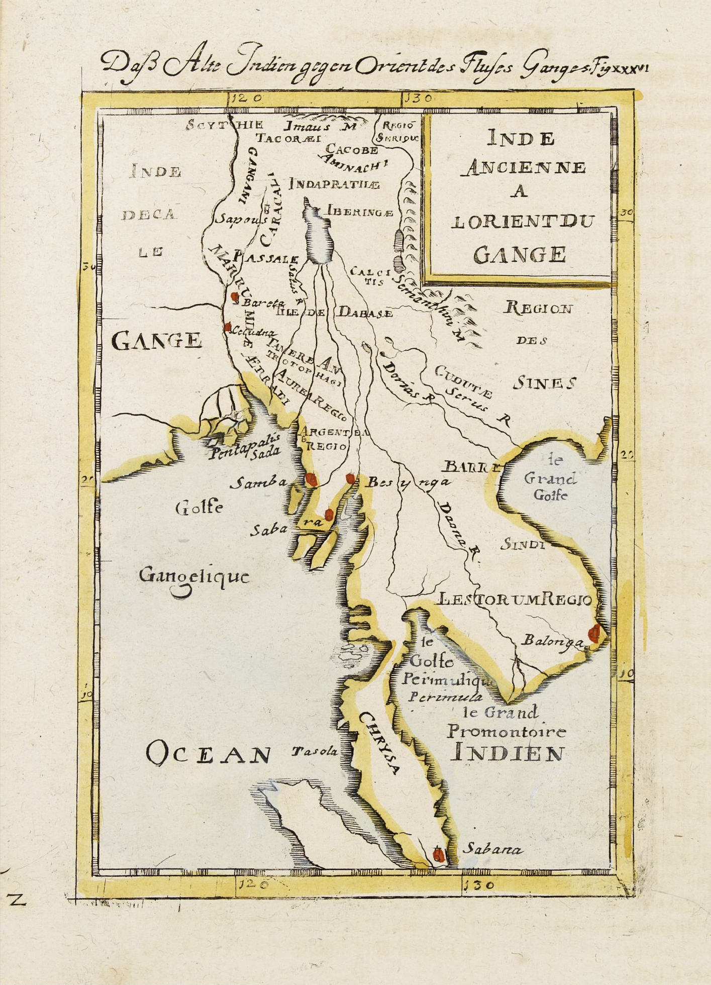
Map of ancient Southeast Asia, 1683.jpg - Baddu676

Map of western Indonesia, 1683.jpg - Baddu676

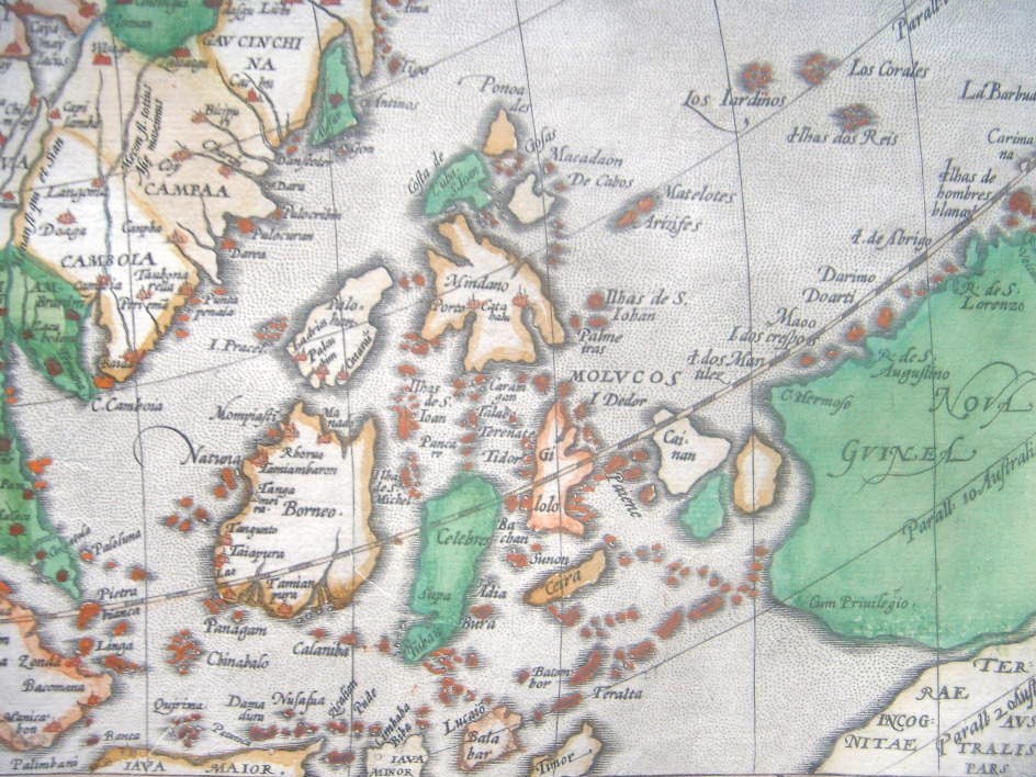
Map of eastern Indonesia, 1683.jpg - Baddu676

Map of New Guinea, 1685.jpg - Baddu676

Map of the Solomon Islands, 1685.jpg - Baddu676

Map of the Philippines, 1683.jpg - Enyavar

Map of Guam and the Mariannas, 1683.jpg - Baddu676

"Asia," by Giovanni Botero, an edition from 1659 southeast.jpg - Baddu676

Asia (1600) southeast.jpg - Baddu676

"Asiae Nova Descriptio," by P. Kaerius, 1614 - South Asia.jpg - Baddu676

"Asiae Nova Descriptio," by P. Kaerius, 1614 - southeast.jpg - Baddu676

De Fer's corresponding miniature map of South India and Southeast Asia, c.1685.jpg - Baddu676

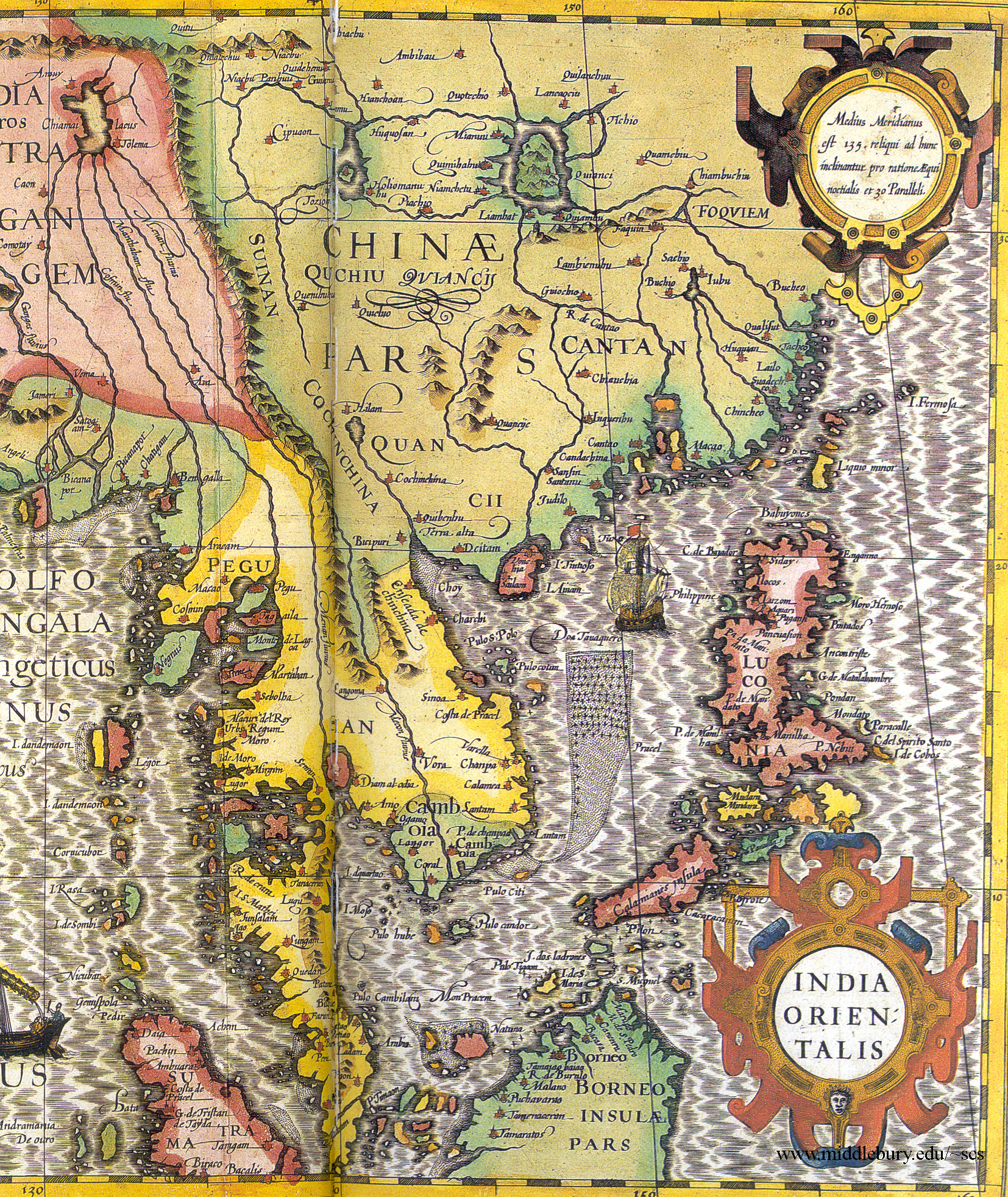
Map of SE Asia, Dutch East Indies, & Philippines LCCN2003663634.jpg - Fæ
Map of SE Asia, Dutch East Indies, & Philippines LCCN2003663634.tif - Fæ

A-3-37-09-India.jpg - Poli.Pav

Kaart van Indonesië en een deel van Zuidoost-Azië India quae Orientalis dicitur et Insulae adiacentes (titel op object), NG-501-73.jpg - Mr.Nostalgic

India quae Orientalis dicitur et Insulae Adiacentes.jpg - Balkanique

Atlante Veneto Volume 1 065.jpg - SteinsplitterBot

B26056104B - India orientalis.jpg - NLSingapore

B26055929E - Carta prima generale dell'Asia.jpg - NLSingapore

B26055933K - India Orientalis nec non insularum adiacentium.jpg - NLSingapore

B26055951K - Mar di India.jpg - NLSingapore

B26055954C - Paskaerte zynde t'Oosterdeel van Oost Indien.jpg - NLSingapore

B26055958G - Tabula geograph in qua Europae, Africae, Asiaeq.jpg - NLSingapore

B26055973D - A new map of East India.jpg - NLSingapore

B26055980B - Isole dell'Indie divise in Filippine, Molucche e della Sonda.jpg - NLSingapore

B26056045F - India orientalis et insula.jpg - NLSingapore

B26056105C - Indes orientalles ou du Gange.jpg - NLSingapore

B26056107E - India orientalis.jpg - NLSingapore

B26056109G - Inde.jpg - NLSingapore

B26056053E - India Orientalis.png - NLSingapore
Asia (1570) southeast (cropped).jpg - User-duck

Peta Asia 1686.jpg - Anton nuryana

Cours du Mé Khong de sa source à son embouchure - avec le cours du Mé-nam et celui des principales rivières de la Chine - btv1b53158018s.jpg - Gzen92Bot

India quae orientalis dicitur, et Insulae adjacentes - Guiljelmus Blaeu - btv1b53179335c (1 of 2).jpg - Gzen92Bot

Tresor des cartes geographiques des principaux estatz de l'univers (...) - btv1b52511195b (59 of 85).jpg - Enyavar

India Orientalis - btv1b531793321 (1 of 2).jpg - Gzen92Bot

Golfe du Siam, Cochinchine et Bornéo - John Thornton - btv1b7200767z (1 of 2).jpg - Gzen92Bot

Abrahami Ortelii Theatrum orbis terrarum parergon ; sive veteris geographiae tabulae, commentariis geographicis et historicis illustratae. Editio novissima, tabulis aliquot aucta, et varie emendata atq.... - btv1b550061506 (139 of 213).jpg - Gzen92Bot

Cartes generales de toutes les parties du monde, ou les empires, monarchies, republiques, estats, peuples, &c. de l'Asie, de l'Afrique, de l'Europe, & de l'Americque, tant anciens que nouveaux, sont... - btv1b52510038g (038 of 388).jpg - Gzen92Bot

Map of Asia from 1641.jpg - Zapata1000

17th century Jollain Map of India, South Asia, Southeast Asia.jpg - AmyNorth