Wikimedi'Òc
Modes d'emploi

Cet album fait partie des albums
Cet album photos contient les sous-albums suivants :


EasterIsland 1772.JPG - Janitoalevic

Zazhevichy 1772 01.jpg - WoukM

Rockall Kerguelen map 1771.jpg - Andy Dingley

Hornsberg 1772.jpg - Holger.Ellgaard
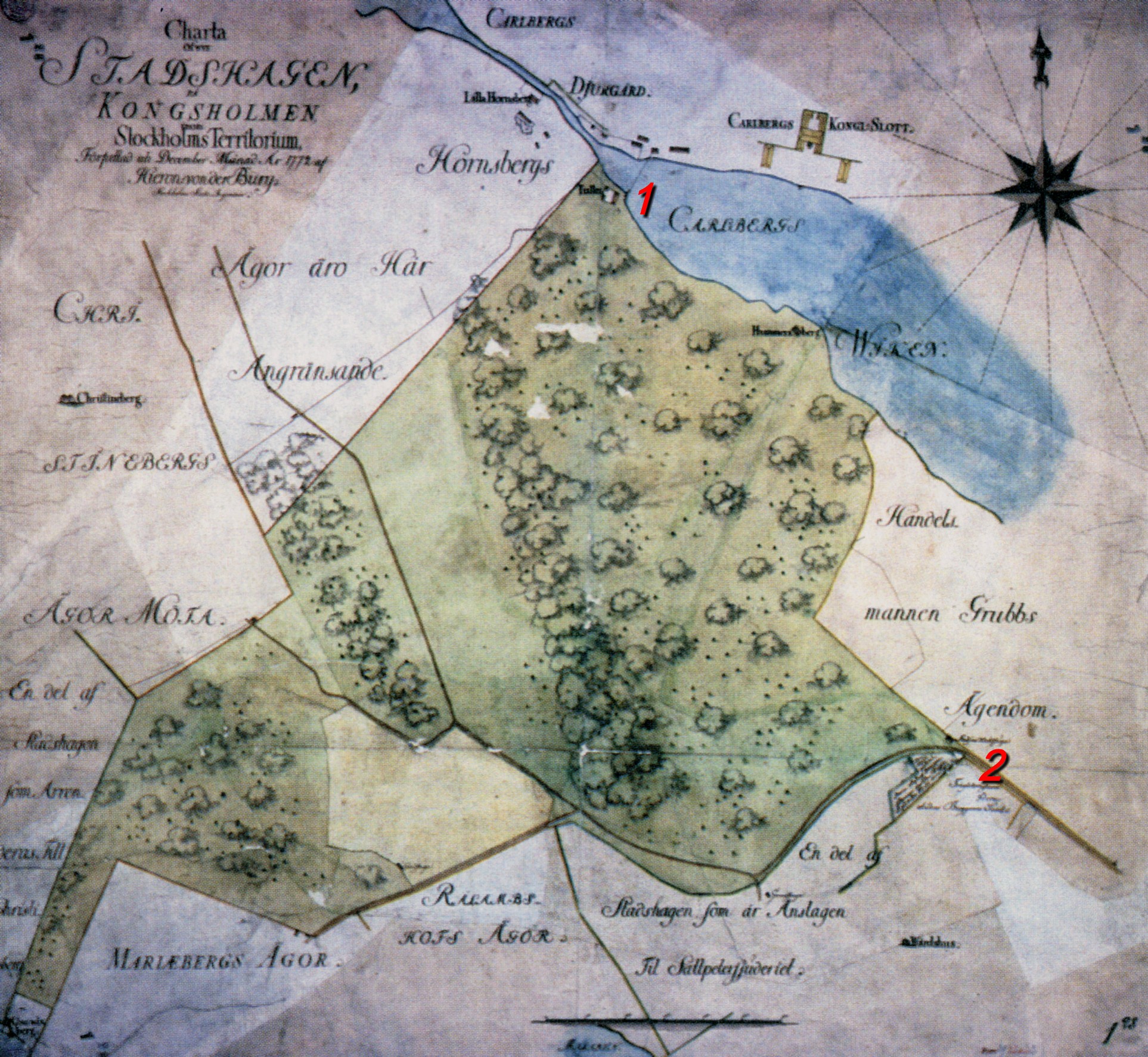
Stadshagen 1772.jpg - Holger.Ellgaard
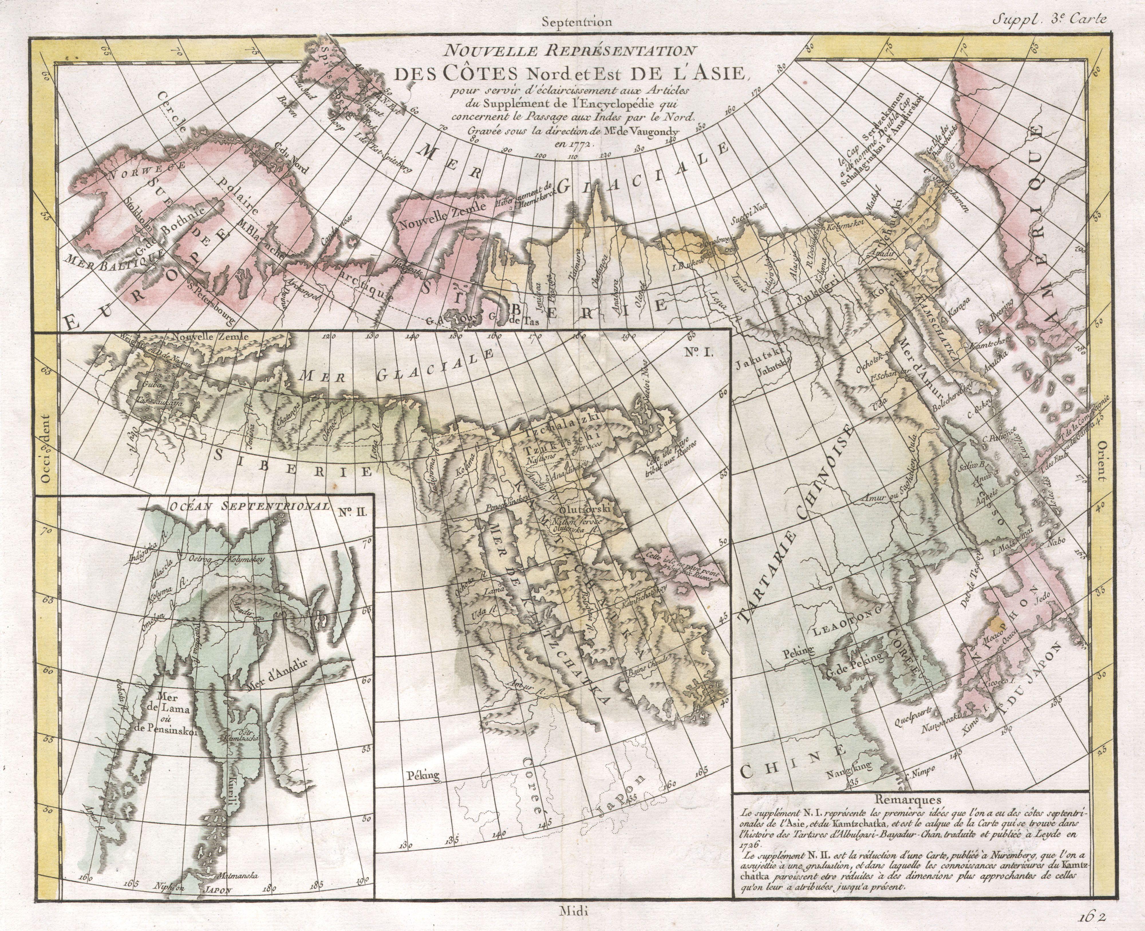
1772 Vaugondy - Diderot Map of Asia and the Northeast Passage - Geographicus - NordEstAsie-vaugondy-1772.jpg - BotMultichill

1772 Vaugondy - Diderot Map of Alaska, the Pacific Northwest ^ the Northwest Passage - Geographicus - DeFonte-vaugondy-1768.jpg - BotMultichill

1772 Vaugondy and Diderot Map of the Pacific Northwest and the Northwest Passage - Geographicus - DeFonteAutres-vaugondy-1772.jpg - BotMultichill

1772 Vaugondy - Diderot Map of Alaska, the Pacific Northwest and the Northwest Passage - Geographicus - NouvellesDecouvertes-vaugondy-1772.jpg - BotMultichill

1772 Vaugondy - Diderot Map of Alaska, the Pacific Northwest ^ the Northwest Passage - Geographicus - DeFonte2-vaugondy-1768.jpg - BotMultichillT
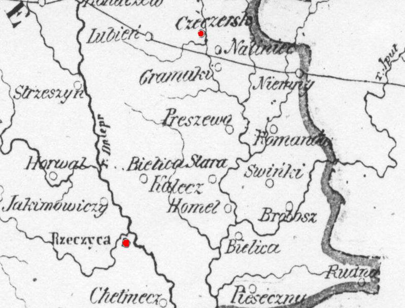
Czaczersk.starostwo-1772.jpg - Krupski Oleg

Schloss Hohenheim Topographischer Plan 1772 detail.jpg - AndreasPraefcke

Schloss Hohenheim Topographischer Plan 1772.jpg - AndreasPraefcke

Sandemar karta 1772.jpg - Holger.Ellgaard

Jassaud map kerguelen expedition 1771 1772.JPG - Kallewirsch

The ancient Tegesta, now promontory of east Florida ... (2674725377).jpg - File Upload Bot (Magnus Manske)

Hydrological map of the Atlantic Ocean, extending from the southernmost part of North America to Europe (2674723037).jpg - File Upload Bot (Magnus Manske)
Nieuwe en nauwkeurige kaart van een gedeelte van Noord Amerika - behelzende Nieuw Engeland, New York, Pennsylvania, New Jersey, Connecticut, Rhode Island, een stuk van Virginia, Kanada en NYPL433627.tiff - Fæ
Plan of the ground between Coenties Slip and White-hall Slip (NYPL Hades-118243-54190).tif - Fæ

The Catholic Netherlands, divided into their several provinces with the roads RMG K1044.jpg - Fæ
Chart of New Zealand, explored in 1769 and 1770 by Lieut. I- Cook,Commander of His Majesty's Bark Endeavour. RMG F0293.tiff - Fæ
Chart of New Zealand, explored in 1769 and 1770 by Lieut. I- Cook,Commander of His Majesty's Bark Endeavour. RMG D9254.tiff - Fæ

Rhode Berlin 1772 (Lotter) (cropped).jpg - Boonekamp

Rhode Berlin 1772 (Lotter) (Bernauer Tor).jpg - Boonekamp

Plan de la baie du Gros Ventre levée en 1772.jpg - AYE R

Hagen Haus Dahl Karte 2.jpg - Bärwinkel,Klaus

Scientia terrarum et coelorum - or, the heavens and earth astronomically and geographically delineated and display'd - containing the most curious & useful particulars in the solar starry & mundane LOC 2017585829.jpg - Fæ
Nieuwe en nauwkeurige kaart van een gedeelte van Noord Amerika, behelzende Nieuw Engeland, New York, Pensylvania, New Jersey, Connecticut, Rhode Island, een stuk van Virginia, Kanada en Halifax, ter LOC 75692514.tif - Fæ
A plan of the division line between the provinces of New-York and Quebec. In the 45th degree of north latitude. Survey'd in the year 1771 & 1772. LOC 74694111.tif - Fæ

A plan of the division line between the provinces of New-York and Quebec. In the 45th degree of north latitude. Survey'd in the year 1771 & 1772. LOC 74694111.jpg - Fæ
The Ancient Tegesta, now Promontory of East Florida. LOC 73694436.tif - Fæ
Carte générale des découvertes de l'amiral De Fonte représentant la grande probabilité d'un passage au nord ouest LOC 74693997.tif - Fæ

Carte générale des découvertes de l'amiral De Fonte représentant la grande probabilité d'un passage au nord ouest LOC 74693997.jpg - Fæ

Nieuwe en nauwkeurige kaart van een gedeelte van Noord Amerika, behelzende Nieuw Engeland, New York, Pensylvania, New Jersey, Connecticut, Rhode Island, een stuk van Virginia, Kanada en Halifax, ter LOC 74692123.jpg - Fæ
A map of the whole continent of America, divided into North and South and West Indies with a copius table fully shewing the several possessions of each European Prince & State, as settled by the LOC 74693198.tif - Fæ

A map of the whole continent of America, divided into North and South and West Indies with a copius table fully shewing the several possessions of each European Prince & State, as settled by the LOC 74693198.jpg - Fæ
A plan of the township of Blenheim, as surveyed and divided in the year 1772. LOC 74692222.tif - Fæ

A plan of the township of Blenheim, as surveyed and divided in the year 1772. LOC 74692222.jpg - Fæ

A map of Potomack and James rivers in North America shewing their several communications with the navigable waters of the new province on the river Ohio. LOC 75693289.jpg - Fæ
Planisphaerium coeleste - secundum restitutionem Hevelianam et Hallejanam LOC 2012589701.tif - Fæ

Planisphaerium coeleste - secundum restitutionem Hevelianam et Hallejanam LOC 2012589701.jpg - Fæ
Mappa da barra de Macao LOC 89696137.tif - Fæ

Mappa da barra de Macao LOC 89696137.jpg - Fæ

Wereldkaart Waereld-Kaart (titel op object), RP-P-1935-796.jpg - Mr.Nostalgic
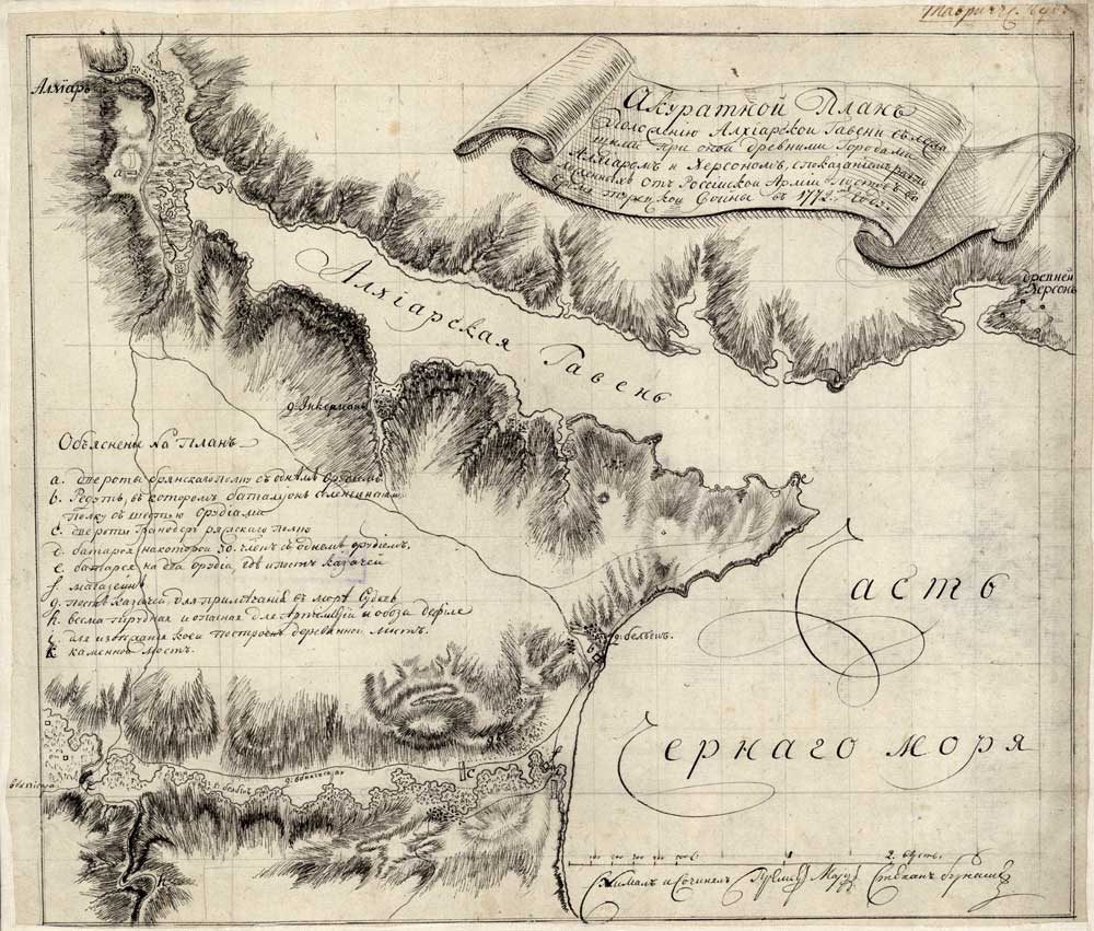
Крым. Карта Ахтиярской(Алхиарской) гавани в 1772г Бурнашев krym-1798.jpg - T3ru

Jean Delagrive, Nouvelle Carte de la Terre Sainte 01-north (FL13736241 2368514).jpg - Geagea

Jean Delagrive, Nouvelle Carte de la Terre Sainte 02-south (FL13736242 2368514).jpg - Geagea

Carsten Niebuhr, Tabula Itineraria a Sues usque ad Dsjaebbel el Mokatteb et Montem Sinai (FL50795223 2368818).jpg - Geagea

Jean Baptiste Bourguignon d'Anville, Asia according to the Sieur d'Anville 01 (FL27959756 2487118).jpg - Geagea

Jean Baptiste Bourguignon d'Anville, Asia according to the Sieur d'Anville 02 (FL27959762 2487118).jpg - Geagea

Didier Robert de Vaugondy, Carte des parties nord et est de l'Asie (FL147398644 2608056).jpg - Geagea
Anthony Cardon, Icon Sinus Baiarum Uti Nuper Videbatur (FL159288477 2591347).jpg - Geagea
Giuseppe Bracci, Icon Sinus Baiarum Uti Nunc Videtur (FL159288483 2591352).jpg - Geagea

Georges-Louis Le Rouge, Le Cours Du Rhin De Bâle à Hert près de Philipsbourg en 5 Feuilles, Contenant L'Alsace Et Partie Du Brisgau 01-sheet-1 (FL39696699 3017180).jpg - Geagea

Georges-Louis Le Rouge, Le Cours Du Rhin De Bâle à Hert près de Philipsbourg en 5 Feuilles, Contenant L'Alsace Et Partie Du Brisgau 02-sheet-2 (FL39696701 3017180).jpg - Geagea

Georges-Louis Le Rouge, Le Cours Du Rhin De Bâle à Hert près de Philipsbourg en 5 Feuilles, Contenant L'Alsace Et Partie Du Brisgau 03-sheet-3 (FL39696702 3017180).jpg - Geagea

Georges-Louis Le Rouge, Le Cours Du Rhin De Bâle à Hert près de Philipsbourg en 5 Feuilles, Contenant L'Alsace Et Partie Du Brisgau 04-sheet-4 (FL39696703 3017180).jpg - Geagea

Georges-Louis Le Rouge, Le Cours Du Rhin De Bâle à Hert près de Philipsbourg en 5 Feuilles, Contenant L'Alsace Et Partie Du Brisgau 05-sheet-5 (FL39696706 3017180).jpg - Geagea

Joseph-Romain Joly, Carte de la route des Israélites depuis leur départ de l'Egypte jusqu'au passage di Jourdain (FL46962315 3922539).jpg - Geagea

Joseph-Romain Joly, Carte de la Terre de Chanaan, avant les conquêtes du Peuple de Dieu (FL45582548 3922553).jpg - Geagea

Joseph-Romain Joly, Carte des villes épiscopales de la Palestine (FL45582553 3922551).jpg - Geagea

Joseph-Romain Joly, Carte des voyages d'Abraham et des Patriarch.ES (FL45582557 3922527).jpg - Geagea

Joseph-Romain Joly, Carte de la Palestine depuis le Captivité de Babylone, Jusqu'a la dernière guerre des Juifs (FL45582594 3922567).jpg - Geagea

Joseph-Romain Joly, Carte de la Palestine selon le partage de douze Tribus (FL45582597 3922560).jpg - Geagea