Wikimedi'Òc
Modes d'emploi

Cet album fait partie des albums
Cet album photos contient les sous-albums suivants :


Non-Native Nations Claim over NAFTA countries 1763.png - Esemono
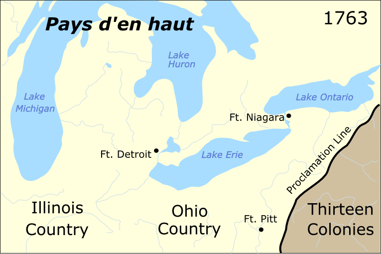
Pontiac's war region.png - OgreBot
A new and accurate map of North America - laid down according to the latest, and most approved observations and discoveries - R. W. Seale, sculpt. NYPL483703.tiff - Sebastian Wallroth
A new and accurate map of North America - laid down according to the latest, and most approved observations and discoveries - R. W. Seale, sculpt. NYPL483704.tiff - Sebastian Wallroth
A new and accurate map of North America - laid down according to the latest, and most approved observations and discoveries - R. W. Seale, sculpt. NYPL434068.tiff - Fæ
A new map of North America from the latest discoveries, 1763 NYPL483714.tiff - Fæ
A new map of North America from the latest discoveries, 1763. NYPL434121.tiff - Fæ
Map of Spanish Louisiana and the American colonies) - J. Gibson, sculp. NYPL434043.tiff - Fæ
Map of Spanish Louisiana and the American colonies.) NYPL483702.tiff - Fæ

New Map of North America (1763).JPG - WCCasey
A New & accurate map of North America - including the British acquisitions gain'd by the late war, 1763 (NYPL b15405502-465046).tiff - SteinsplitterBot

A New & accurate map of North America - including the British acquisitions gain'd by the late war, 1763 (NYPL b15405502-465046).jpg - SteinsplitterBot
A new and accurate map of the British dominions in America, according to the Treaty of 1763, divided into the several provinces and jurisdictions - projected upon the best authorities and astronomical LOC 86695760.tif - Fæ

A new and accurate map of the British dominions in America, according to the Treaty of 1763, divided into the several provinces and jurisdictions - projected upon the best authorities and astronomical LOC 86695760.jpg - Fæ
A New map of North America from the latest discoveries. LOC 75693984.tif - Fæ

A New map of North America from the latest discoveries. LOC 75693984.jpg - Fæ
A new map of the British Dominions in North America; with the limits of the governments annexed thereto by the late Treaty of Peace, and settled by Proclamation, October 7th 1763. LOC 75696331.tif - Fæ

A new map of the British Dominions in North America; with the limits of the governments annexed thereto by the late Treaty of Peace, and settled by Proclamation, October 7th 1763. LOC 75696331.jpg - Fæ
North America. LOC 75693503.tif - Fæ

North America. LOC 75693503.jpg - Fæ
America Septentrionalis a Domini d'Anville in Galliis edita nunc in Anglia. Coloniis in interiorem Virginiam deductis nec non Fluvii Ohio aucta cursu notisque geographicis et historicis illustrata. LOC 73693706.tif - Fæ

America Septentrionalis a Domini d'Anville in Galliis edita nunc in Anglia. Coloniis in interiorem Virginiam deductis nec non Fluvii Ohio aucta cursu notisque geographicis et historicis illustrata. LOC 73693706.jpg - Fæ
A new map of North America, shewing the advantages obtain'd therein to England by the peace LOC 2015591095.tif - Fæ

A new map of North America, shewing the advantages obtain'd therein to England by the peace LOC 2015591095.jpg - Fæ
Carte des possessions angloises & françoises du continent de l'Amérique septentrionale, LOC 74695021.tif - Fæ

Carte des possessions angloises & françoises du continent de l'Amérique septentrionale, LOC 74695021.jpg - Fæ
A new and accurate map of the British dominions in America, according to the treaty of 1763; divided into the several provinces and jurisdiction, Projected upon the best authorities and astronomical LOC 74695316.tif - Fæ

A new and accurate map of the British dominions in America, according to the treaty of 1763; divided into the several provinces and jurisdiction, Projected upon the best authorities and astronomical LOC 74695316.jpg - Fæ
A new map of North America from the latest discoveries. LOC 74695015.tif - Fæ

A new map of North America from the latest discoveries. LOC 74695015.jpg - Fæ
An accurate map of North America describing and distinguishing the British and French dominions on this great continent according to the definitive treaty concluded at Paris 10th February 1763. LOC 74694142.tif - Fæ

An accurate map of North America describing and distinguishing the British and French dominions on this great continent according to the definitive treaty concluded at Paris 10th February 1763. LOC 74694142.jpg - Fæ
(Colonial America) LOC 2015591097.tif - Fæ

(Colonial America) LOC 2015591097.jpg - Fæ
A new and accurate map of North America, laid down according to the latest, and most approved observations and discoveries. LOC 74692226.tif - Fæ

A new and accurate map of North America, laid down according to the latest, and most approved observations and discoveries. LOC 74692226.jpg - Fæ

A new map of North America, with the British, French, Spanish, Dutch & Danish dominions..., according to the definitive treaty concluded at Paris 10th February 1763, by J. B. B. Anville and Didier Robert de Vaugondy - commonwealth 4m90f.jpg - Daderot

The British governments in Nth America laid down agreeable to the proclamation of Octr. 7, 1763 - DPLA - 05ba7d1a2adfbfd36317f8c1c6bf9e24.jpg - DPLA bot

Dury Atlas Map 8 North America.jpg - LlywelynII