Wikimedi'Òc
Modes d'emploi

Cet album fait partie des albums
Cet album photos contient les sous-albums suivants :


Map Vienna 1710.jpg - LSDSL

1710-Wien-Steinhausen-Roter Turm.jpg - Fg68at

Andaluzia - Gabriel Bodenehr.jpg - Ecemaml

Plan af København 1710.jpg - Anne-Sophie Ofrim

Ducatus Wurtenbergici 1.jpg - FA2010
Ducatus Wurtenbergici 2.jpg - FA2010

1710 First Japanese Buddhist Map of the World Showing Europe, America, and Africa - Geographicus - NansenBushu-hotan-1710.jpg - BotMultichillT

1710 De La Feuille Map of the Netherlands, Belgium and Luxembourg - Geographicus - 17Provinces-laveuille-1710.jpg - BotMultichillT
1710 First Japanese Buddhist Map of the World Showing Europe, America, and Africa - Geographicus - Nansenbushu-rokashihotan-1710.jpg - BotMultichillT

RamapoughVillage.jpg - Fredlyfish4

PatentMap.jpg - OgreBot

A new and exact map of the United Provinces, or Netherlands &c. (8341706985).jpg - File Upload Bot (Magnus Manske)

To the Right Honourable William, Lord Cowper, Lord High Chancellor of Great Britain, this map of Asia ... (8341623555).jpg - File Upload Bot (Magnus Manske)

Carte geographique des abbayes et monasteres de la congregation de St. Maur avec les archevechez et evechez de France (4587185502).jpg - File Upload Bot (Magnus Manske)

Fortifikationsplan von Rapperswil, 1710 M. L. Kaufflin - Stadtmuseum Rapperswil - 'Stadt in Sicht - Rapperswil in Bildern' 2013-10-05 16-24-56 (P7700).jpg - Roland zh
Ducatus Wurtenbergici 2 cropped.jpg - AxelHH

Ducatus Wurtenbergici in totum.jpg - MagentaGreen
Karta över omgivningarna vid Cambray, Bappaumes, St Quentin, Perone, 1710 - Skoklosters slott - 98032.tif - LSHuploadBot

Ducatus Wurtenbergici 1 (Detail).jpg - MagentaGreen
A new and correct large draught of the Channell between England and France with the coast of Ireland St. Georges and Bristoll Channell and several of the most noteable harbours at large. RMG F0518.tiff - Fæ
Karte Schlesien von Petrus Schenk 1710 flächenkoloriert.jpg - Ratzer

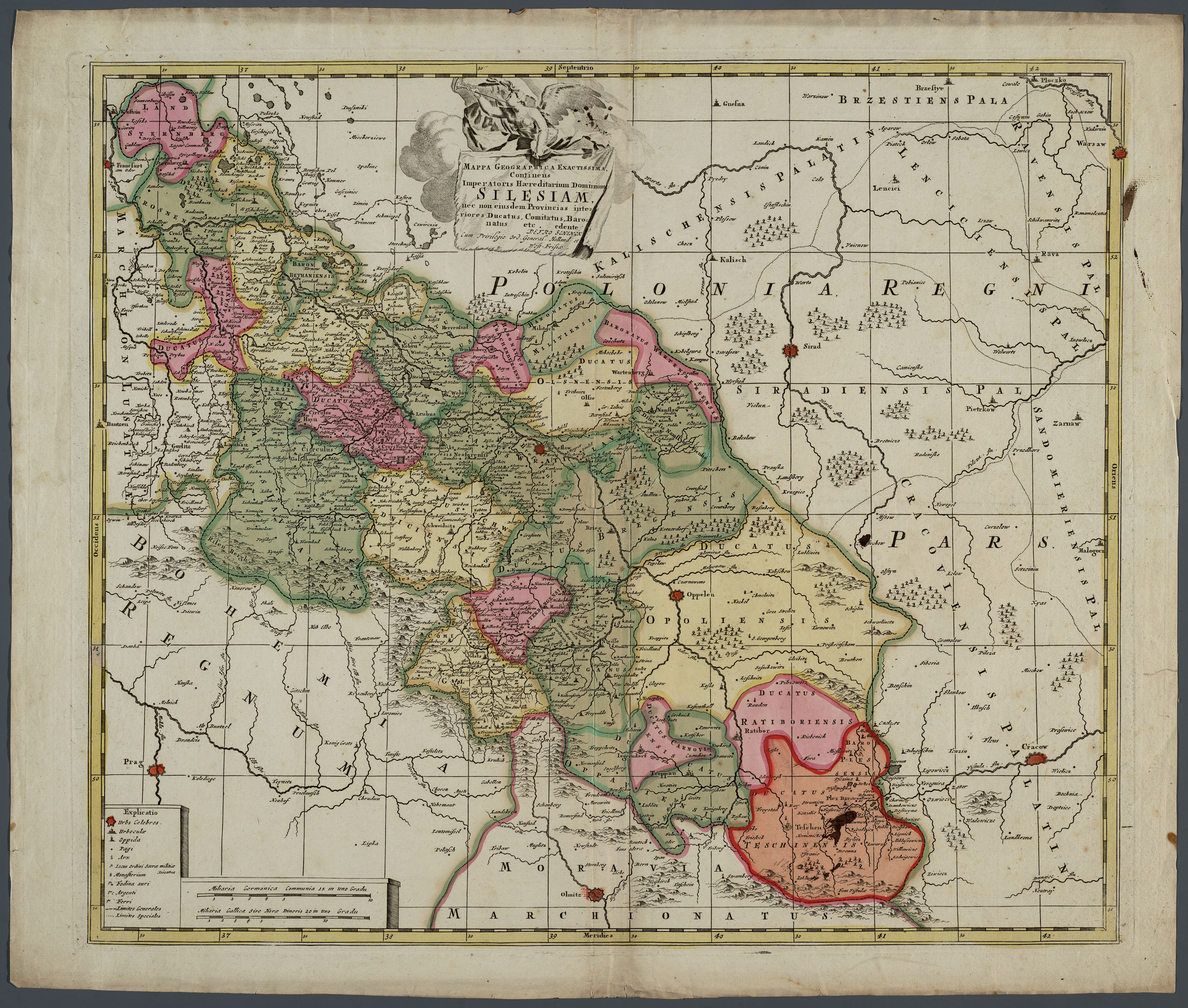
Karte Schlesien von Petrus Schenk 1710.jpg - Ratzer
Tabula Mexicae et Floridae - terrarum Anglicarum, et anteriorum Americae insularum, item cursuum et circuituum fluminis Mississipi dicti. LOC 2004629008.tif - Fæ

Tabula Mexicae et Floridae - terrarum Anglicarum, et anteriorum Americae insularum, item cursuum et circuituum fluminis Mississipi dicti. LOC 2004629008.jpg - Fæ
Nansenbushū bankoku shōka no zu LOC 96685908.tif - Fæ

Nansenbushū bankoku shōka no zu LOC 96685908.jpg - Fæ

1710 Samuel Thornton. A new and correct large draught of the Channell between England and France with the coast of Ireland St. Georges & Bristoll Channell and several of the most noteable harbours at large (detalle).jpg - Orestes 71

A plan of the Isle of Portland and parts adjacent 1710.png - Austiger

Hemisphere meridional ou Antarctique du globe terrestre - veu en convexe l'oeil etantpose au zenith et a distance infinie du plan de projection contenant partie de l'Afrique, partie de l'Amerique meridionale et les t.png - Austiger

Asia - qua nulla beatior ora ; tractus in eoos vergens mundique teporem.png - Austiger
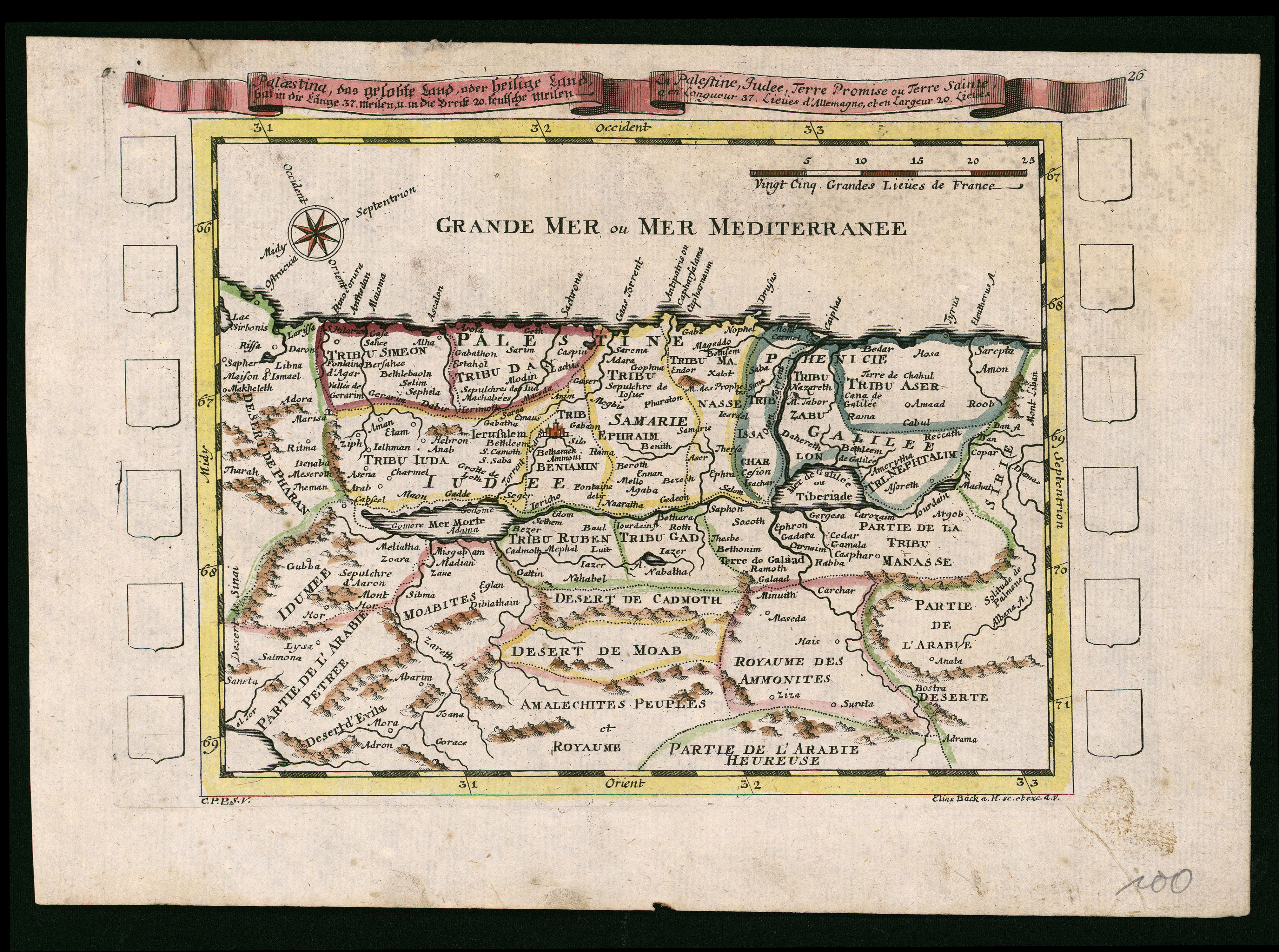
Elias Baeck, Palaestina, das Gelobte Land, oder Heilige Land (FL200036749 2368347).jpg - Geagea

Adam Friedrich Zürner, Terra Sancta s.Palaestina oder das Gelobte Land (FL199398053 2369196).jpg - Geagea

Johann Christoph Steinberger, South Asia (FL35865337 2491854).jpg - Geagea

R. Spofforth, A New map of Libya or old Africk, shewing its general divisions, most remarkable countries or people, cities, townes, rivers, mountains & c (FL35470273 2499125).jpg - Geagea

Pierre Moullart-Sanson, Description geographique de la Terre Promise (FL35080858 3888727).jpg - Geagea

Pierre Moullart-Sanson, Carte Pour l'Intelligence des Voiages d'Abraham, Faits par l'ordre de Dieu, en Asie et en Egypte (FL35080874 3888714).jpg - Geagea

Tabula Altera quæ Continet Potissima Asiæe (FL36011214 2819766).jpg - Geagea

Nicolaes Visscher II, Nouvelle carte de la Mer Noire et du Canal de Constantinople (FL36011251 2878085).jpg - Geagea

Johann Baptist Homann, Ducatuum Livoniae et Curlandiae cum vicinis Insulis Nova Exhibitio Geographica (FL36379261 2606387).jpg - Geagea

Peter Schenk the Younger, La Russie blanche ou Moscovie (FL36379279 2606418).jpg - Geagea

Syria et Palaestina (FL36559274 3901654).jpg - Geagea
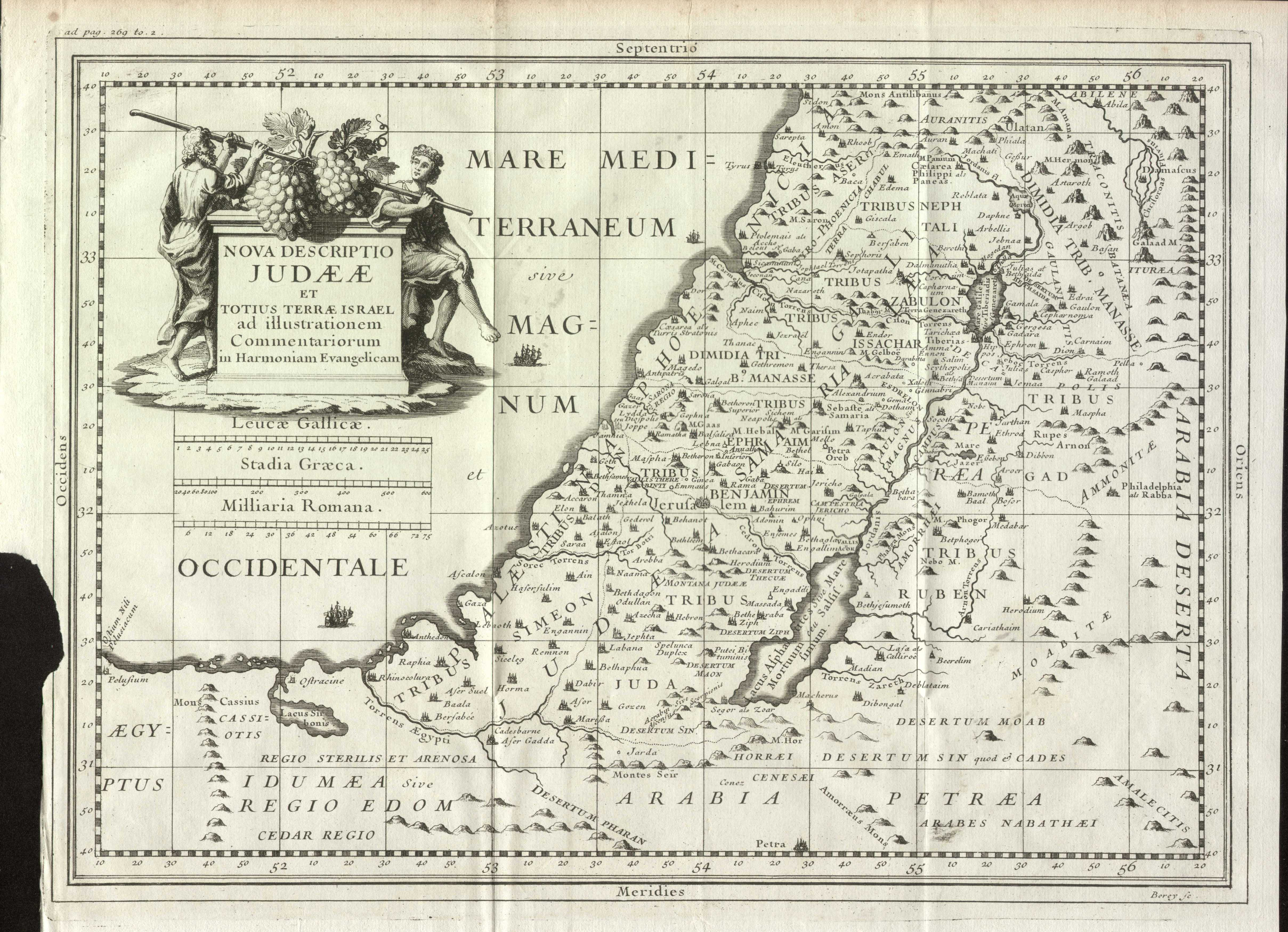
Nova Descriptio Judaeae et Totius Terrae Israel ad illustrationem Commentariorum in Harmoniam Evangelicam (FL37124142 3899433).jpg - Geagea

Das Land Canaan samt der wüsten durch welche das volck Israel gezogen da sie aus Aegypten giengen (FL46962596 3935127).jpg - Geagea
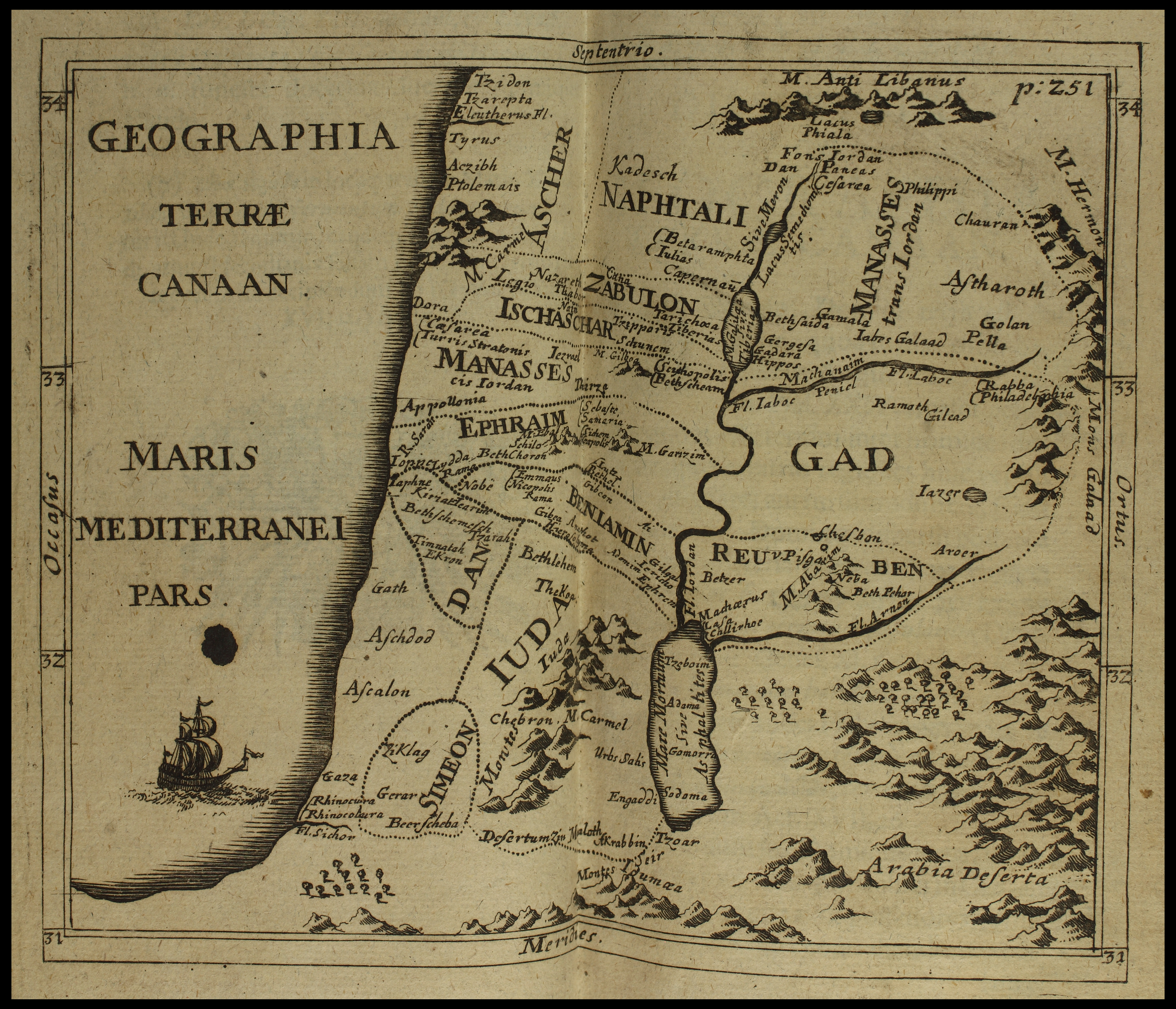
Thomas Godwyn, Geographia Terræ Canaan (FL48326236 3954774).jpg - Geagea

Grundriss der Stadt Jerusalem wie sie furnemlich zur zeit dess hern Christi.beschaften Gewessen (FL49973458 4073152).jpg - Geagea

Jean Leclerc, Iter Israelitarum per Arabicas solitudines (FL45602037 3935123).jpg - Geagea

Jean Leclerc, Tabula Terrae Sanctae in usum eorum, qui Pentateuchum legunt (FL45602050 3935122).jpg - Geagea

Johann Ludwig Gleditsch, Reisen der Patriarchen (FL45611852 3950697).jpg - Geagea

Terra sancta das gelobte land (FL45611855 3950705).jpg - Geagea

Johann Ludwig Gleditsch, Reise der kinder Israel aus Aegypten ins gelobte landn (FL45611876 3950698).jpg - Geagea

Friedenskirchen und Gnadenkirchen in Schlesien 01.jpg - Derbrauni

Friedenskirchen und Gnadenkirchen in Schlesien 02.jpg - Derbrauni