Wikimedi'Òc
Modes d'emploi

Cet album fait partie des albums
Cet album photos contient les sous-albums suivants :


(Plan of the town and harbour of St. Augustine. LOC 75693262.tif - Fæ

"A New and Accurate Plan of the town of St. Augustine" (9126561850).jpg - Fæ

A plan of the land between Fort Mossy and St. Augustine in the province of East Florida. LOC 73691558.jpg - Fæ
A plan of the land between Fort Mossy and St. Augustine in the province of East Florida. LOC 73691558.tif - Fæ

A new & accurate plan, of the town of St. Augustine, LOC 73694477.jpg - Fæ

Elixio de la Puente Map of St. Augustine.jpg - Carlstak
St. Augustine and its environs. LOC 73691561.tif - Fæ

St. Augustine and its environs. LOC 73691561.jpg - Fæ

Preliminary chart of St. Augustine harbor, Florida LOC 99447281.jpg - Fæ
Preliminary chart of St. Augustine harbor, Florida LOC 99447281.tif - Fæ

Plan du port de St. Augustin dans la Floride. LOC 73694475.jpg - Fæ
Plan du port de St. Augustin dans la Floride. LOC 73694475.tif - Fæ

Plan du port de St. Augustin dans la Floride. LOC 74692211.jpg - Fæ
Plan du port de St. Augustin dans la Floride. LOC 74692211.tif - Fæ

Plan du port de St. Augustin dans la Floride. LOC 77690267.jpg - Fæ
Plan du port de St. Augustin dans la Floride. LOC 77690267.tif - Fæ

Plan of St. Augustine LOC 2006628351.jpg - Fæ
Plan of St. Augustine LOC 2006628351.tif - Fæ

Plan of the inlet, strait, & town of St. Augustine. LOC 73691560.jpg - Fæ
Plan of the inlet, strait, & town of St. Augustine. LOC 73691560.tif - Fæ

Plano de la ciudad y puerto de San Agustin de la Florida. LOC 73694479.jpg - Fæ
Plano de la ciudad y puerto de San Agustin de la Florida. LOC 73694479.tif - Fæ

(Plan of the town and harbour of St. Augustine. LOC 75693262.jpg - Fæ

View of the city of St. Augustine, Fla. (2674663334).jpg - File Upload Bot (Magnus Manske)

St. Augustine Map 1763.jpg - 7mike5000

Thomas Jeffrey's Map St. Augustine.jpg - 7mike5000
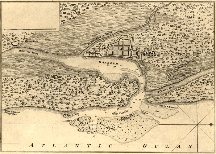
Plan of the Town and Harbour of St. Augustine, 1762.jpg - Carlstak

FAIRBANKS(1858) p074 Map of the mouth of St. Johnes River.jpg - Metilsteiner

Reservation, Anastasia Island and St. Francis Barracks, Florida - DPLA - 2bfb8c850e93f32486d6df5d871eb771 (page 1).jpg - DPLA bot

Florida -Hamilton County - Sarasota County (part)- - NARA - 17474775 (page 1651).jpg - US National Archives bot

1940 Census Enumeration District Maps - Florida - St. Johns County - St. Augustine - ED 55-6 - ED 55-21 - NARA - 5829767.jpg - US National Archives bot

1950 Census Enumeration District Maps - Florida (FL) - St. Johns County - St. Augustine - ED 55-1 to 21 - NARA - 12007965.jpg - US National Archives bot

View of the Town and Castle of St. Augustine.jpg - Carlstak

Plano del Sitio de la Florida 1740.jpg - Carlstak

Florida -Hamilton County - Sarasota County (part)- - NARA - 17474775 (page 1637).jpg - US National Archives bot

Florida -Hamilton County - Sarasota County (part)- - NARA - 17474775 (page 1638).jpg - US National Archives bot

Florida -Hamilton County - Sarasota County (part)- - NARA - 17474775 (page 1650).jpg - US National Archives bot

Florida -Hamilton County - Sarasota County (part)- - NARA - 17474775 (page 1652).jpg - US National Archives bot

Autour du Golfe de Mexique - par le Sr d'Anville - btv1b8596179c.jpg - Gzen92Bot

StAugustine1702Siege.jpg - Magicpiano

Northern Part of Florida. Compiled and Published at the United States Coast Survey Office, A. D. Bache... - NARA - 305412.jpg - US National Archives bot

Williams map 1837.jpg - Carlstak

(1737) Delineatio munimenti et Portus S.AUGUSTINI by Homann Heirs.jpg - Metilsteiner

REYNOLDS(1885) p031 Fort Caroline.jpg - Metilsteiner

REYNOLDS(1885) p040 San Augustin.jpg - Metilsteiner

REYNOLDS(1885) p049 Fort Marion.jpg - Metilsteiner

REYNOLDS(1885) p110 St. Augustine, the CAPITAL of EAST FLORIDA.jpg - Metilsteiner

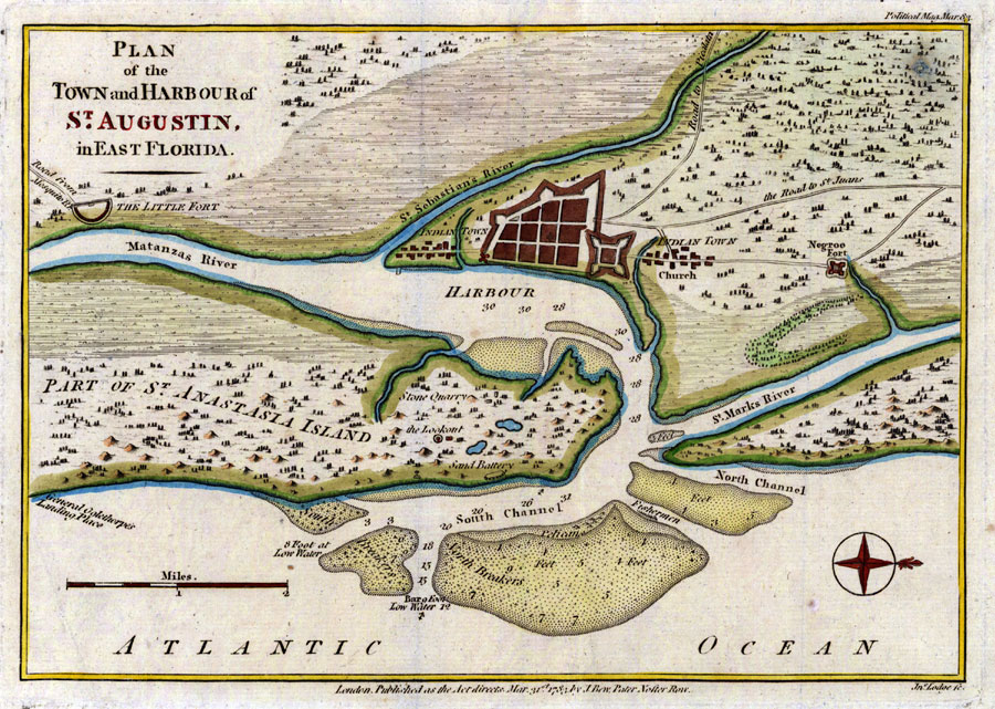
Plan of Town and Harbour of St. Augustine.jpg - Carlstak
Plan of St. Augustin in East Florida, 1783.jpg - Isinbill

Plano de la Ciudad y Puerto de San Agustin de la Florida (8900730155).jpg - Fæ

"A View of the Town and Castle of St. Augustine, and the English Camp before it June 20 1740" (9124092669).jpg - Fæ

A plan of the harbour of St Augustin in the province of Georgia composed and published from surveys deposited in the Office of the Right Honourable the Lords of Trade RMG K0881.jpg - Fæ

A plan of the harbour of St Augustin in the province of Georgia composed and published from surveys deposited in the Office of the Right Honourable the Lords of Trade RMG K0880.jpg - Fæ

A plan of the harbour of St Augustin in the province of Georgia composed and published from surveys deposited in the Office of the Right Honourable the Lords of Trade RMG K0879.jpg - Fæ

A plan of the harbour of St Augustin in the province of Georgia composed and published from surveys deposited in the Office of the Right Honourable the Lords of Trade RMG D9550 3.jpg - Fæ

40 of 'Old Saint Augustine. A story of three centuries' (11307147876).jpg - Artix Kreiger 2

110 of 'Old Saint Augustine. A story of three centuries' (11181336633).jpg - FlickreviewR 2

31 of 'Old Saint Augustine. A story of three centuries' (11306769205).jpg - Artix Kreiger 2

Plan of Fort Picolata.jpg - Carlstak

Plano de la ciudad y puerto de San Agustin de la Florida, 1783.jpg - Infrogmation
Plano de la ciudad y puerto de San Agustin de la Florida, 1783.tif - Infrogmation

A Plan of St. Augustine Town and its Environs in East Florida - DPLA - ea20eb2b3f9595f96a0d723e87f7801e.jpg - DPLA bot

A View of the Town and Castle of St. Augustine, and the English Camp before it June 20, 1740 - The Gentleman's Magazine, 1740.jpg - Broichmore

St. Augustine Harbour, crop of Les principales forteresses, ports etc.jpg - Enyavar

Map of San Augustin during war, 1740.jpg - Enyavar