Wikimedi'Òc
Modes d'emploi

Cet album fait partie des albums
Cet album photos contient les sous-albums suivants :


Kingdom of Lombardy-Venetia 1815.svg - Alphathon

Kingdom of Prussia 1812.svg - Sbb1413

Kingdom of Saxony 1812.svg - Alphathon

Kingdom of Saxony 1815.svg - Alphathon

Kingdom of Württemberg 1815.svg - Alphathon

Kingdom of Westphalia 1812.svg - Alphathon

Grand Duchy of Baden 1815.svg - Alphathon

Kingdom of Bavaria 1812.svg - Alphathon

Kingdom of Bavaria 1815.svg - Alphathon

Kingdom of Hanover 1815.svg - Alphathon

LatinMonetaryUnion 1866-1914.svg - Sechsachtel
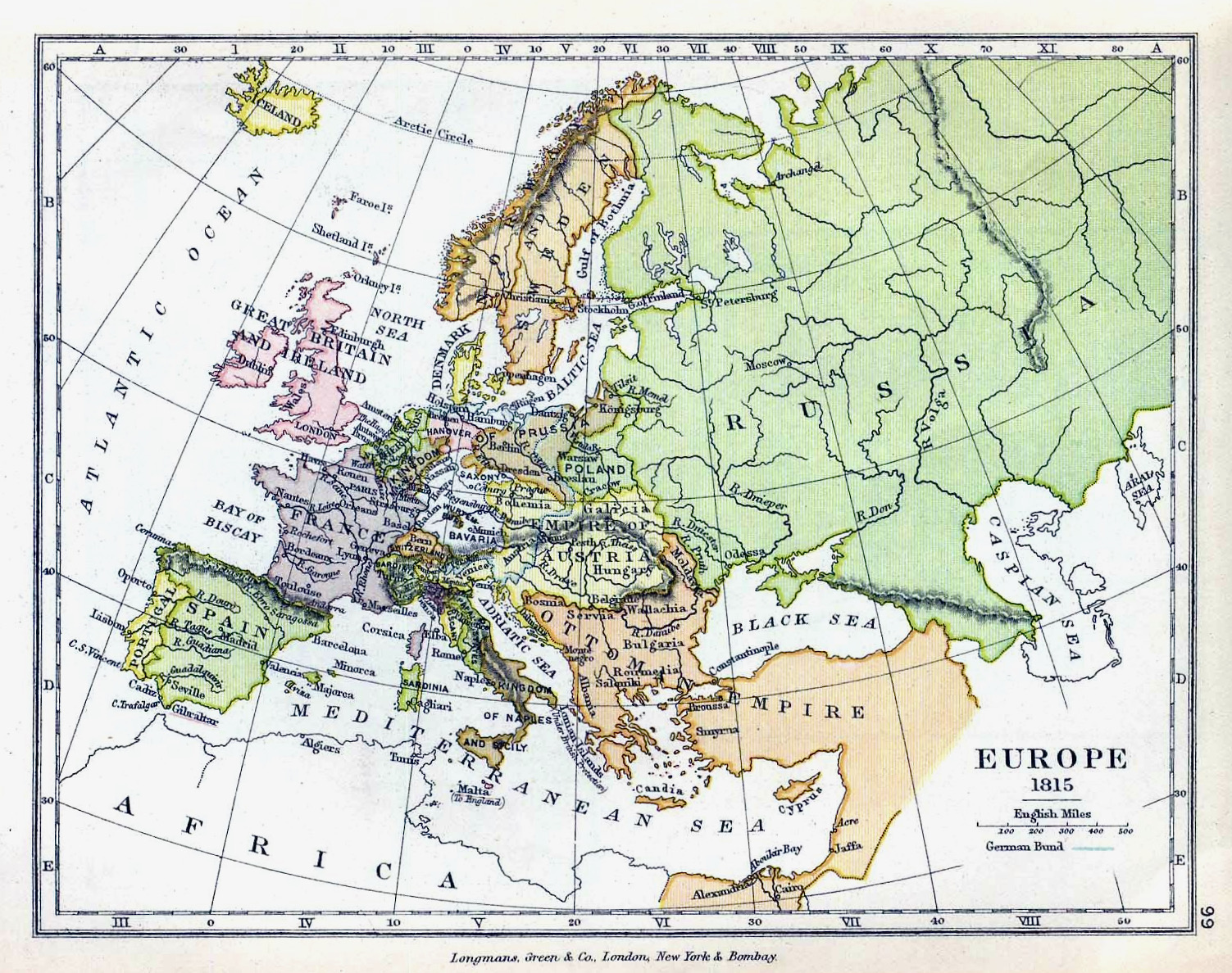
Europe1815 1905.jpg - LeontinaVarlamonva

Karte Mediation.png - Sidonius

Strategic Situation of Western Europe 1814.jpg - Cave cattum

Strategic Situation of Western Europe 1815.jpg - Hohum

Railwayneteurope1896.JPG - Alex:D

Karte kongresspolen.png - JayCubby
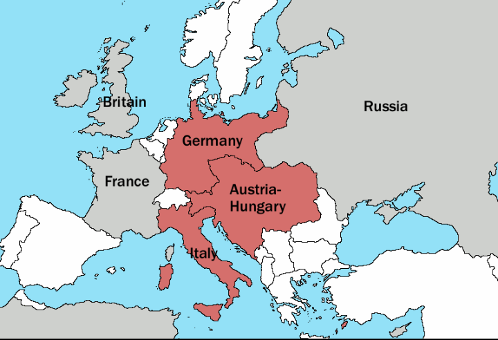
Triple Alliance.png - Barjimoa

Revolutions of 1848 in Europe (pasopt eng).svg - Tryphon

Duchyofwarsaw1810.jpg - Kiejstut9

Podzial Ks Warszawskiego na departamenty.png - LMK3
Blank map of Napoleonic Europe.png - Рагин1987
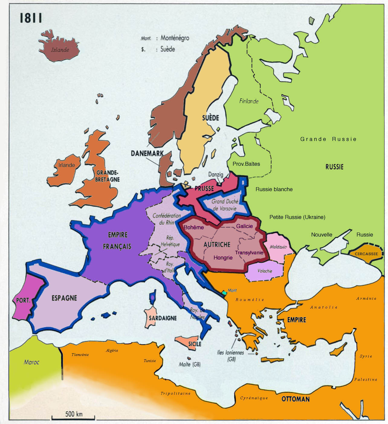
AtHistEur1811.jpg - Spiridon Ion Cepleanu

AtHistEur1840.jpg - Spiridon Ion Cepleanu

AtHistEur1885.jpg - Spiridon Ion Cepleanu
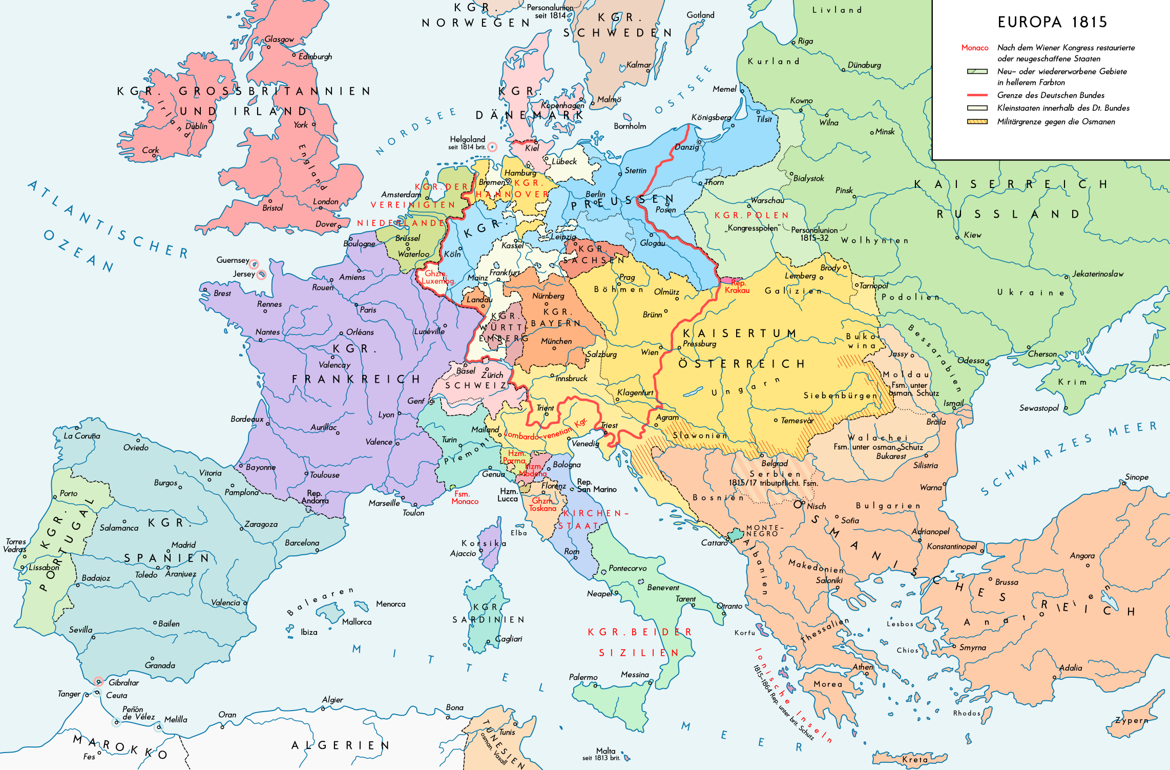
Kaart Europa na het Weens Congres.jpg - File Upload Bot (Magnus Manske)

Europa w czasach Napoleona (Ultima Thule).png - File Upload Bot (Magnus Manske)

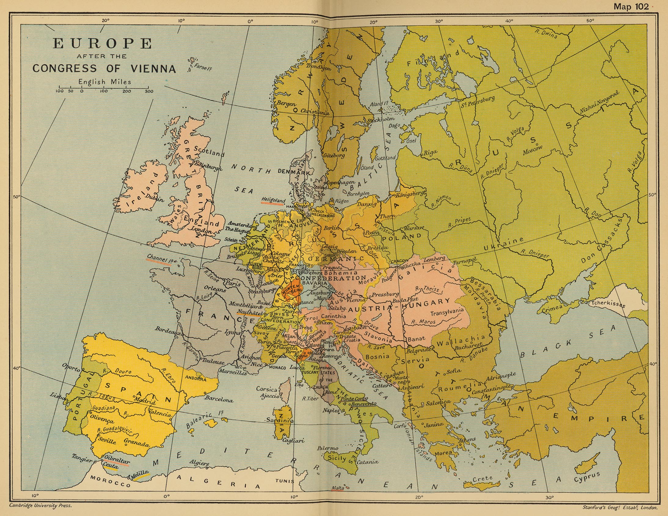
Map congress of vienna.jpg - Ras67

First French Empire 1812.svg - Alphathon
Blank map of Europe 1890.svg - Alphathon
Blank map of Europe 1812.svg - Alphathon

Principality of Bulgaria (1890).svg - Alphathon
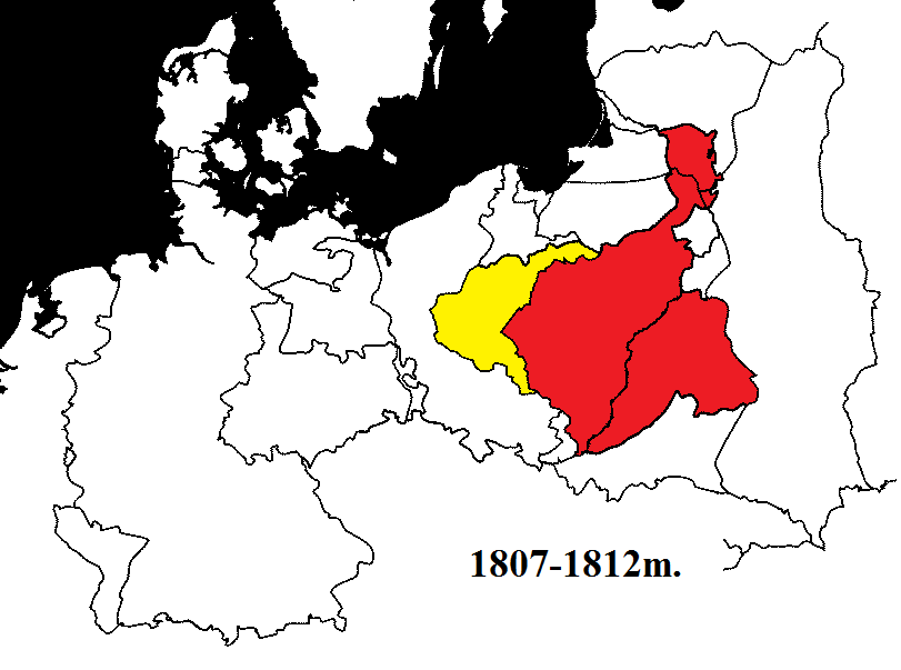
Varšuvos kunigaikštystė 1807-1812m.png - Calcacas

Kingdom of Greece (1890).svg - Alphathon

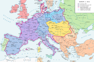
Europe 1812 map de.png - KaterBegemot

Europe 1812 map en.png - KaterBegemot
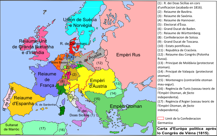
Euròpa après lo Congrès de Viena (1815).png - Nicolas Eynaud

Zollverein (1834).png - Nicolas Eynaud

Southeast Europe 1812 map en.PNG - Trecătorul răcit
Blank map of Europe 1815.svg - Alphathon

Kingdom of Prussia 1815.svg - Alphathon

Austrian Empire 1815.svg - Alphathon

Grand Duchy of Luxembourg 1815.svg - Alphathon

United Kingdom of the Netherlands 1815.svg - Alphathon

German Confederation 1815.svg - E-960

Free City of Kraków 1815.svg - Alphathon

Kingdom of Sardinia 1815.svg - Alphathon

Congress Poland 1815.svg - Alphathon

Map1848.jpg - RFARKAS
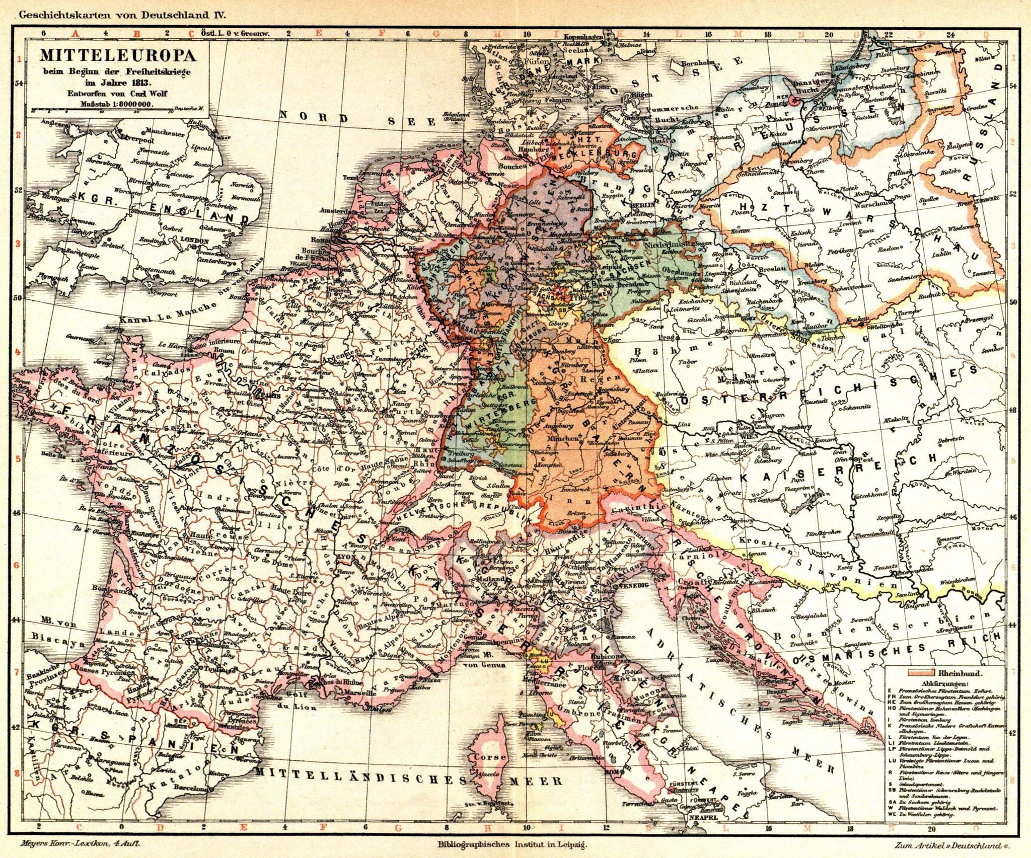
Meyers b4 s0884a.jpg - Mapmarks
Blank map of Europe 1839.svg - Alphathon

Map of Europe 1866.svg - Elevatorrailfan

Outlines of nineteenth century history (1906) (14597268840).jpg - Fæ

Outlines of nineteenth century history (1906) (14781611874).jpg - Fæ

Mediaeval and modern history (1905) (14777980461).jpg - Fæ

The story of the map of Europe, its making and its changing (1916) (14778374675).jpg - Fæ

Modern history; Europe (1904) (14579139950).jpg - SteinsplitterBot

Modern history; Europe (1904) (14765816235).jpg - SteinsplitterBot

Modern history; Europe (1904) (14785683873).jpg - SteinsplitterBot

Fürstentum Erfurt 1812.svg - OwenBlacker
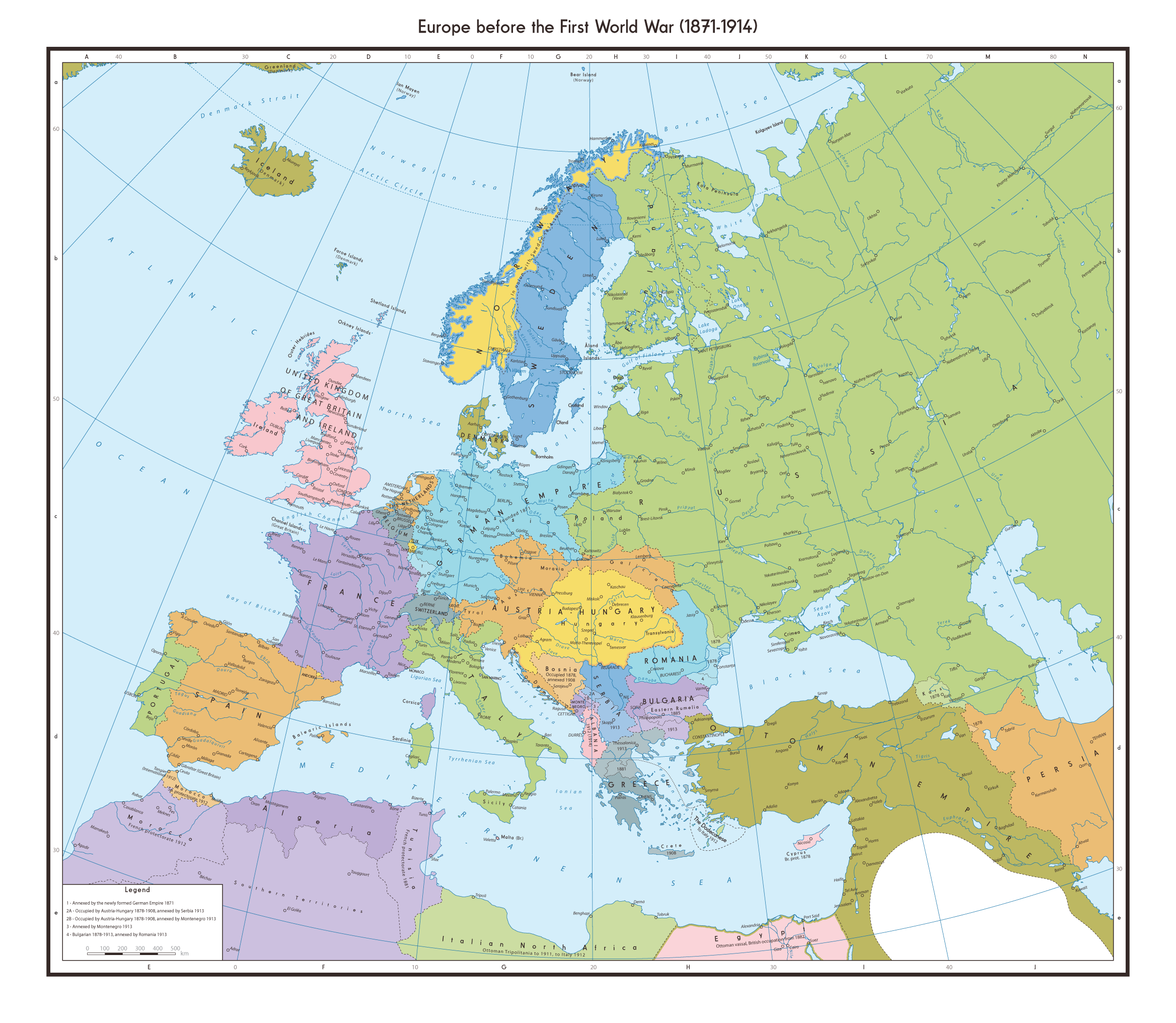
Europe before the First World War (1871 to 1914).png - AugusteBlanqui

Europe 1815 map en.png - KaterBegemot
Europe 1815 map de.png - KaterBegemot

Europe 1848 map de.png - KaterBegemot

Europe 1848 map en.png - KaterBegemot

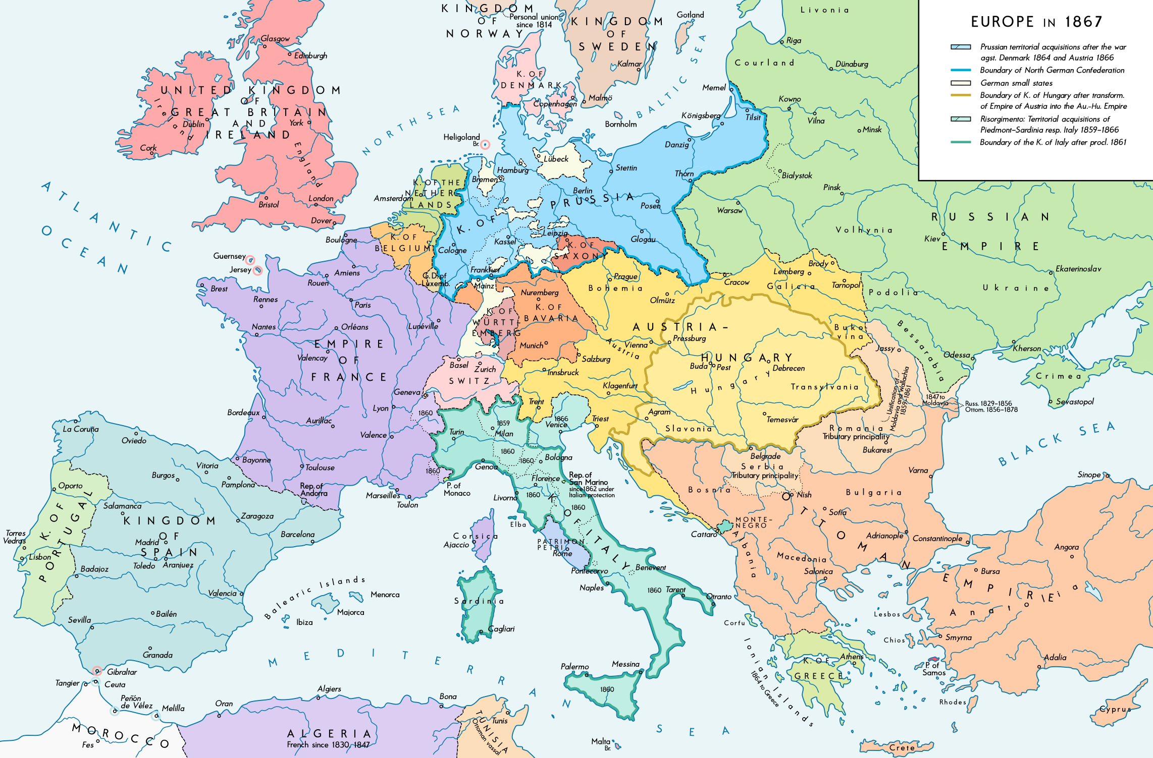
Europe 1867 map de.png - KaterBegemot
Europe 1867 map en.png - KaterBegemot

Europe 1871 map de.png - KaterBegemot
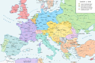
Europe 1878 map de.png - KaterBegemot
Spruner-Menke Handatlas 1880 Karte 11.jpg - A. Wagner

Europa 1812.svg - Lalpino

Europe 1871 map en.png - KaterBegemot
Europe 1878 map en.png - KaterBegemot
Europe 1848 map ru.png - KaterBegemot

Berliner Konferenz 1880.svg - NordNordWest

Europe 1813.jpg - FDRMRZUSA

Plan zum Gefecht bei Missunde 1864.jpg - 1970gemini

610 of 'Outlines of Universal History. Designed as a text-book and for private reading' (11216899145).jpg - FlickreviewR 2

289 of 'Overzicht der algemeene en vaderl. geschiedenis, met 20 historische Kaarten, voor de hoogere Klassen, etc' (11220442904).jpg - FlickreviewR 2

601 of 'Outlines of Universal History. Designed as a text-book and for private reading' (11215769454).jpg - FlickreviewR 2

Europe in the time of Napoleon I (1810).jpg - FDRMRZUSA

A General History for Colleges and High Schools - Map 17.png - Sp1nd01

United Kingdom of Great Britain and Ireland 1812.svg - ชาวไทย
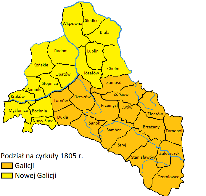
Galicja i Nowa Galicja - cyrkuły 1805.png - D T G
Europe en 1800.pdf - Alain.gourmaud
Europe en 1850.pdf - Alain.gourmaud

Strategic Situation of Western Europe 1814 (cropped to NE France).jpg - Dumelow
Karta öfver Råda socken i Wärmeland och Elfvedals härad.tif - Belteshassar
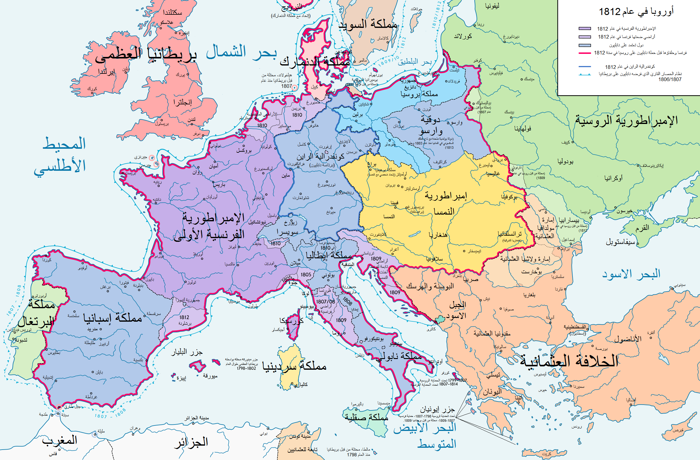
Europe 1812 map ar.png - معتز الوحيشي

Strategic Situation of Western Europe 1814 (cropped to 10 Feb).jpg - Dumelow

Strategic Situation of Western Europe 1814 (cropped to 1 january).jpg - Dumelow

إيطاليا قبل حروب التوحيد.png - معتز الوحيشي

Europa 1812-es.svg - Rowanwindwhistler

Historical atlas of modern Europe 1903 (135895403).jpg - Polona Upload

Historical atlas of modern Europe 1903 (135895410).jpg - Polona Upload

Historical atlas of modern Europe 1903 (135895452).jpg - Polona Upload

Europe en 1812 (c. 1854).jpg - One2

1815年的德意志邦联.png - 巫恒

Spruner-Menke Hand-Atlas fur die Geschichte des Mittelalters und der neueren Zeit. 1880 (137083622).jpg - Enyavar

Map Germany in 1815 1928-1940 - Touring Club Italiano CART-TRC-57 01.jpg - Marta Arosio (WMIT)

Map Germany in 1870 1928-1940 - Touring Club Italiano CART-TRC-57 02.jpg - Marta Arosio (WMIT)

Map of European countries banning American pork imports in the 1880s.png - NorthropChicken

Europa BV042517765 (cropped).jpg - Enyavar

Карта Чечни в эпоху Ермолова 1818―1826 г.jpg - Takhirgeran Umar

Kaiserreich Österreich bis 1867, Karte von 1871.png - Moodylo333

United Principalities of Moldavia and Wallachia (1860).png - NoincludN

109 - Empire Francais en 1810 - Géographie historique. Leçons en regard des cartes.jpg - Enyavar

Carte historique du Luxembourg.jpg - VulpesVulpes42