Wikimedi'Òc
Modes d'emploi

Cet album fait partie des albums
Cet album photos contient les sous-albums suivants :


2014 European Men-s Handball Championship Result.png - Soerfm
North and south of the Pyrenees (Year 760).jpg - Iñaki LLM
No-map.png - Mathias-S
Slavic peoples 9c map.jpg - Berillium
Au-map.png - Kontrollstellekundl

Poland 1569 map.jpg - Kpjas

Poland 1634-1660 map.jpg - Kpjas

Poland 1795 map.jpg - Kpjas

Poland 1772 map.jpg - Kpjas
Polandmap cia gdansk.png - Michiel1972
Slovakia-map.png - Gmelfi

Poland topo.jpg - Captain Blood~commonswiki
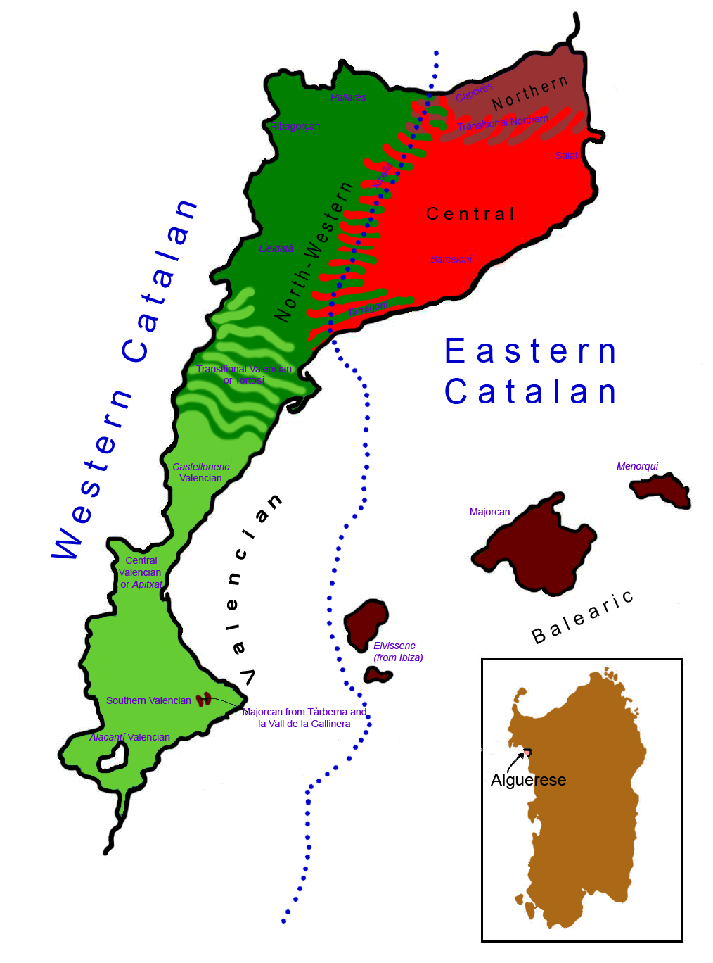
Dialectal map of Catalan Language.png - Pepetps
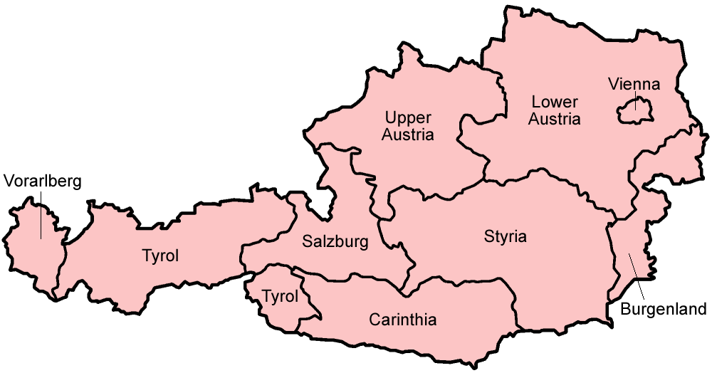
Austria states english.png - Golbez
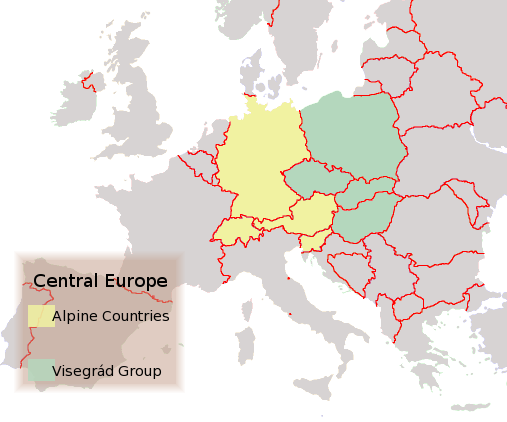
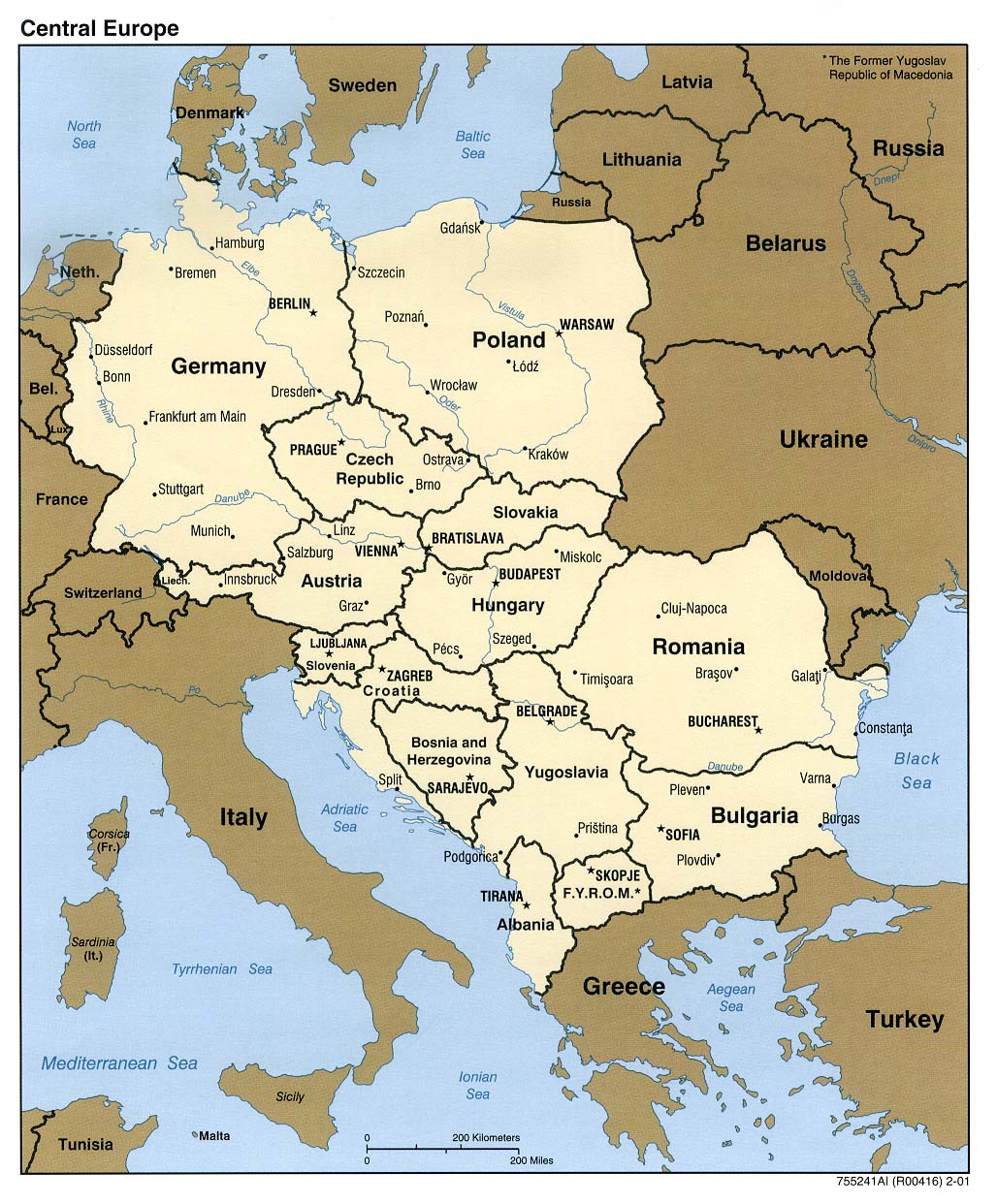
Central Europe.png - Hardscarf

Independent Television ITV regional map 1962-1964.png - Redvers

Independent Television ITV regional map 1964-1968.png - Redvers

Independent Television ITV regional map 1968-1974.png - Redvers

Lux topo en.jpg - Captain Blood~commonswiki

Europe 1914.jpg - DrKay

Italian Wine Regions.jpg - Pierpao
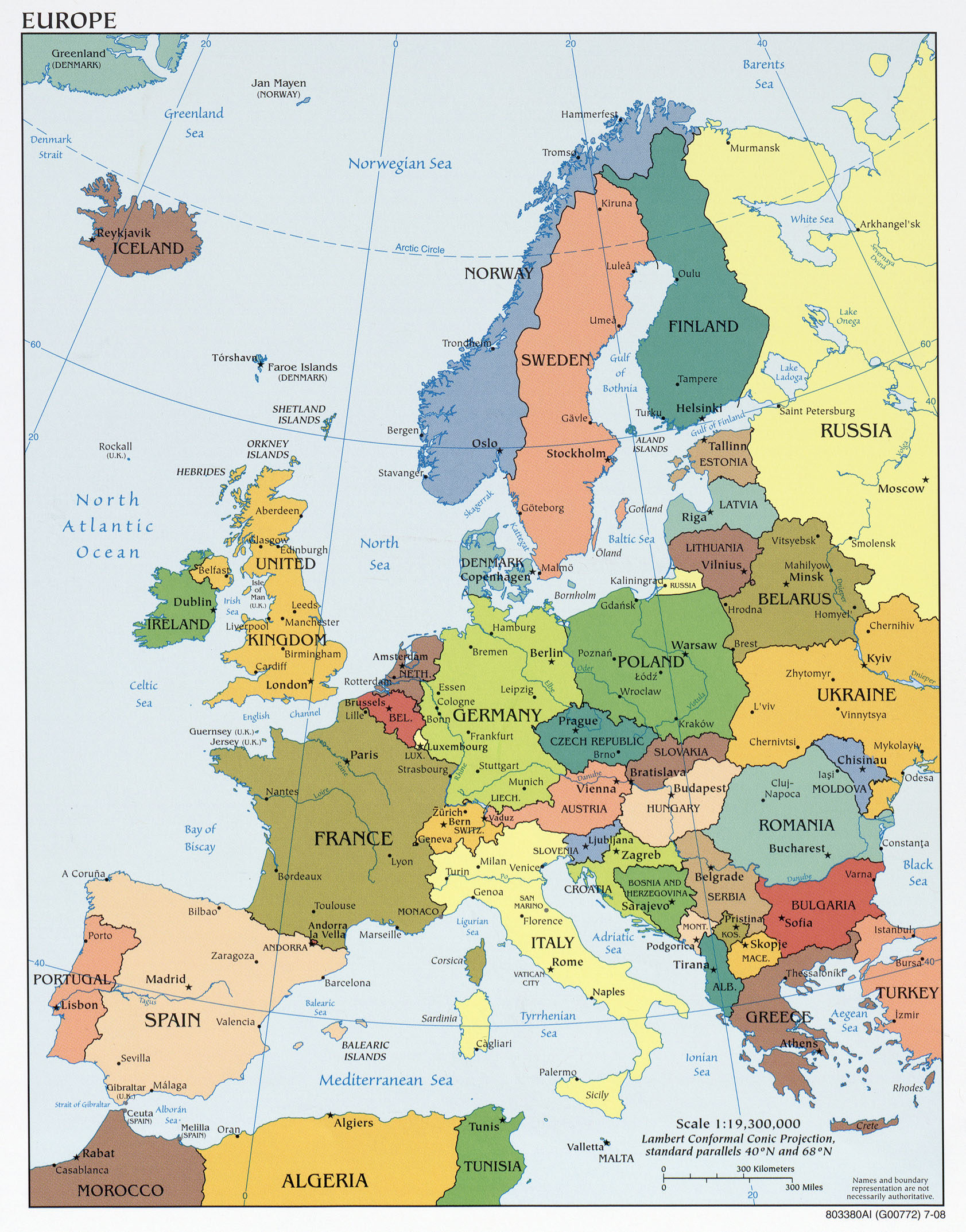
Europe countries map en.png - Wiz9999
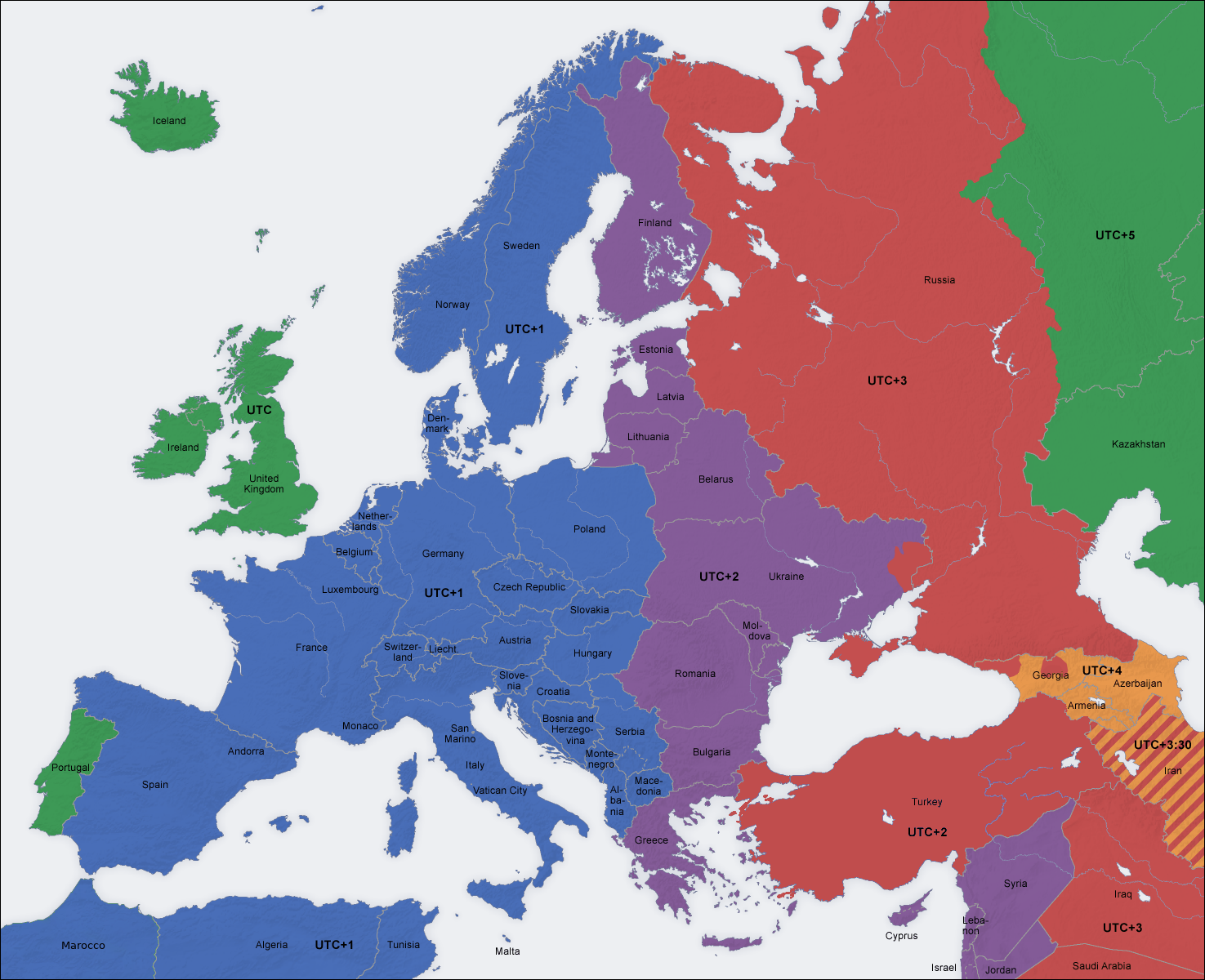
Europe time zones map en.png - Iktsokh

Europe topography map en.png - Ras67

Template europe map en.png - San Jose

Poland airports 2005.png - Slawojar
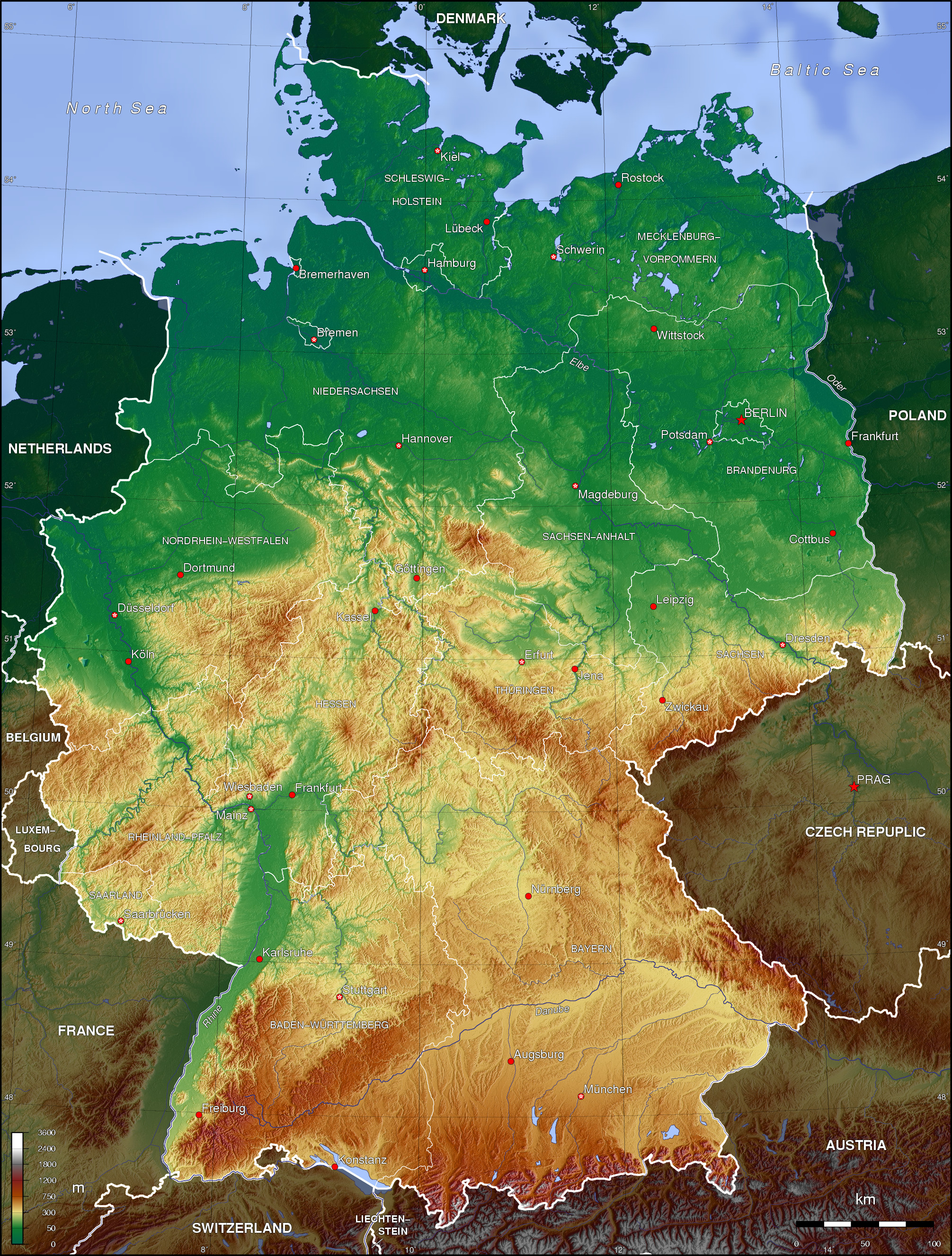
Germany topo.jpg - Captain Blood~commonswiki
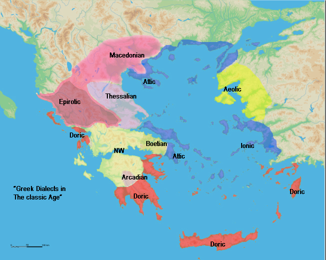
Greek dialects.png - EastMedmaps
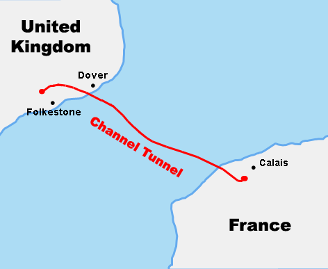
Course Channeltunnel en.png - Weyoune~commonswiki
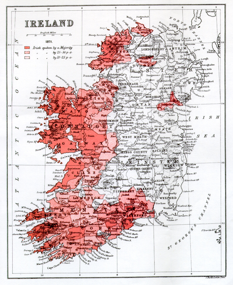
Irishin1871.jpg - Furfur
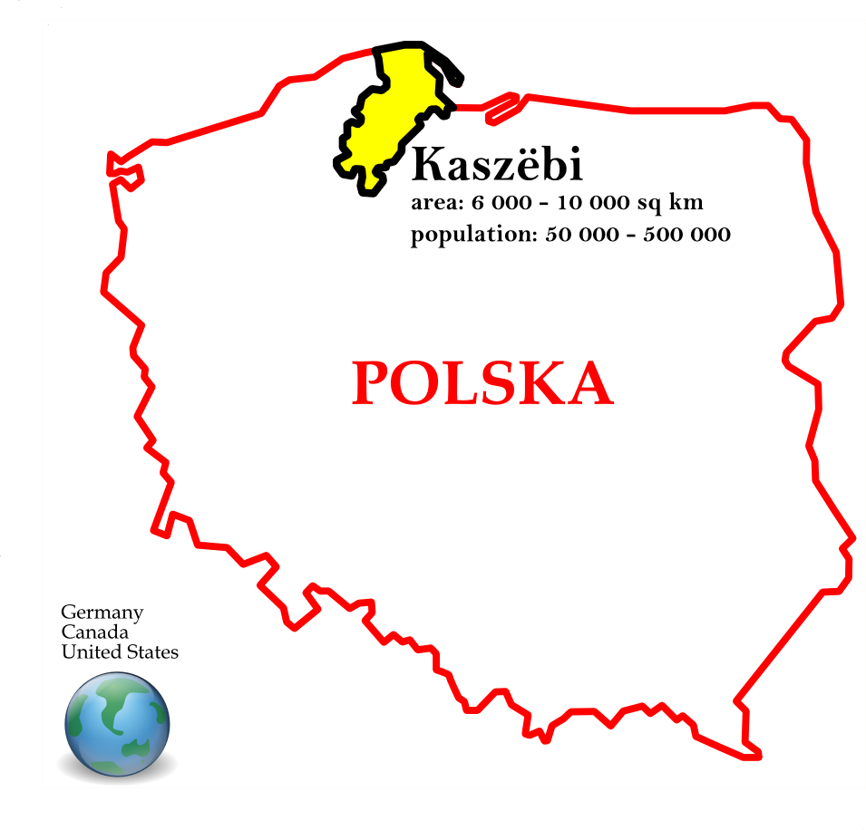
Kashubians in Poland.png - Krzysztof

Kashubians in Poland with polstats big.png - Krzysztof

Bubonic plague map 2.png - Master of Puppets
Savarivermap.png - Ras67

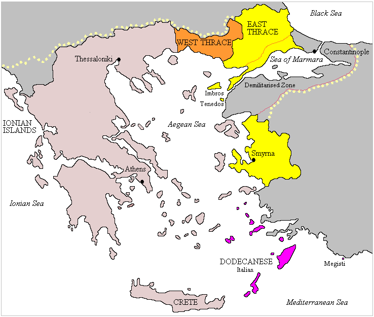
ExpansionofModernGreece.png - DrKay

CATALAN COUNTRIES 2.PNG - Onofre Bouvila~commonswiki
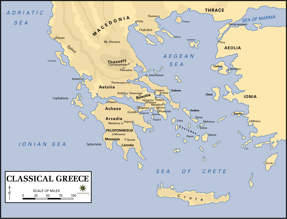
Greecemap.gif - Shauni
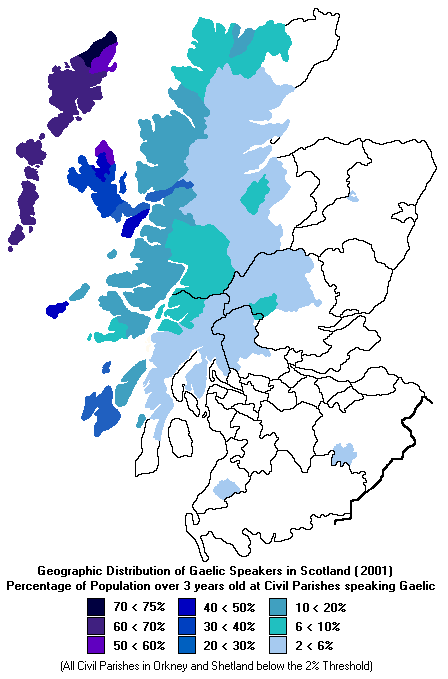
ScotlandGaelicSpeakers2001.gif - Sgitheanach~commonswiki

4.7KentEngland4.28.07.jpg - DragonFire1024
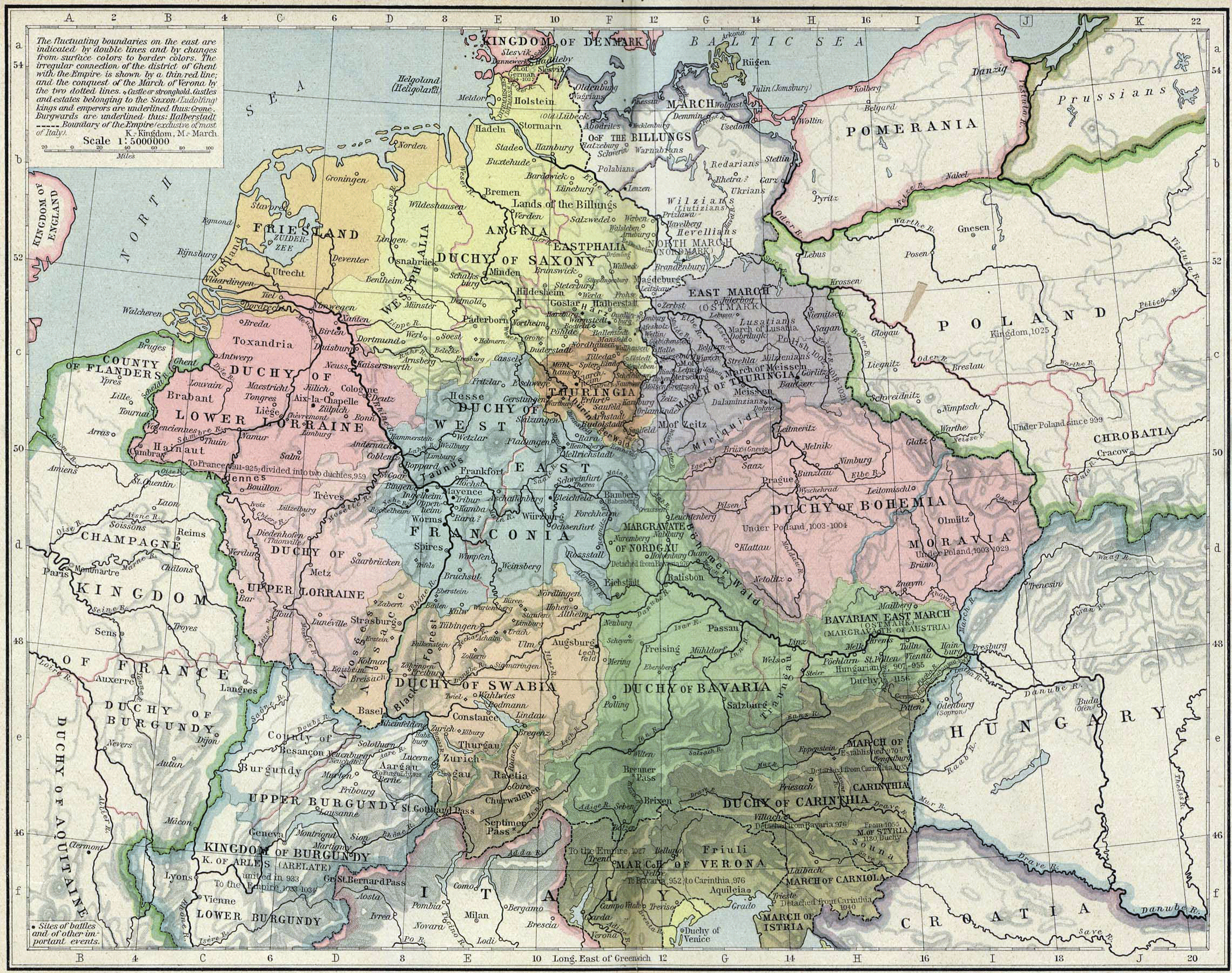
Central europe 919 1125.png - TUVOK~commonswiki

Europe-large.png - Papa November

Map-Battle of Suomussalmi-eng.png - Ukas

Castile (PSF).jpg - Cecil

Centre of Europe.jpg - Wizzard

Kattowitz map simple.jpg - Xlkce~commonswiki

St Kilda map with Gaelic.PNG - Ruhrfisch
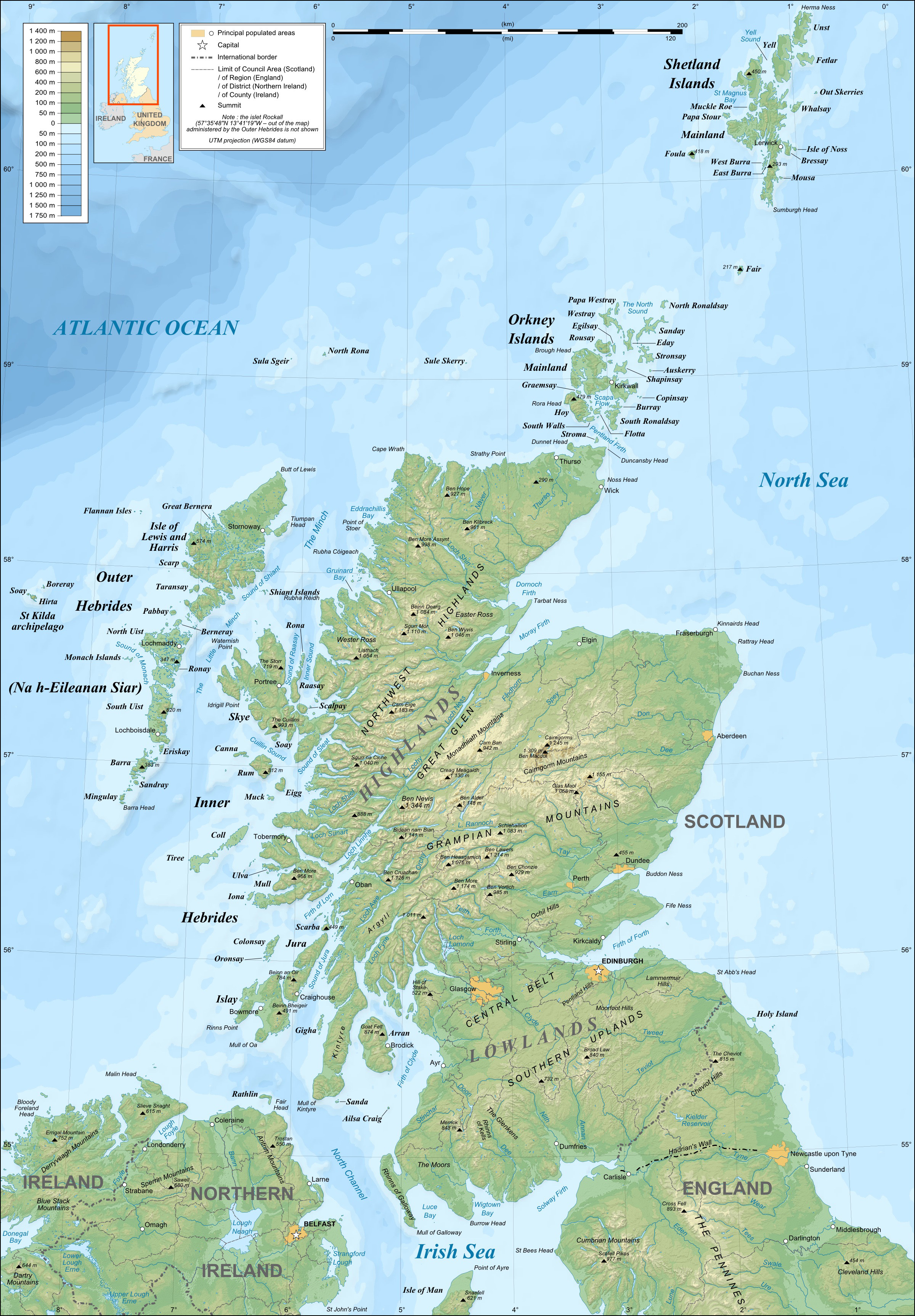
Scotland topographic map-en.jpg - Sting

Scotland map-en.jpg - Sting

South Slavic isoglosses en.png - Kostja2
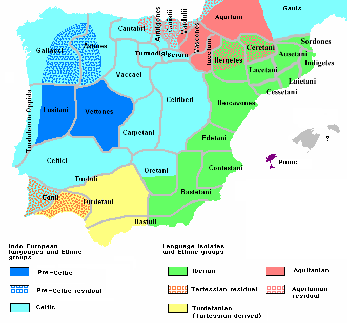
Ethnographic Iberia 200 BCE.PNG - Jafeluv

Physico-Geographical Regionalization of Poland.png - Qqerim

Iberia Late Bronze.gif - File Upload Bot (Magnus Manske)
Central Europe (CIA).jpg - Olahus
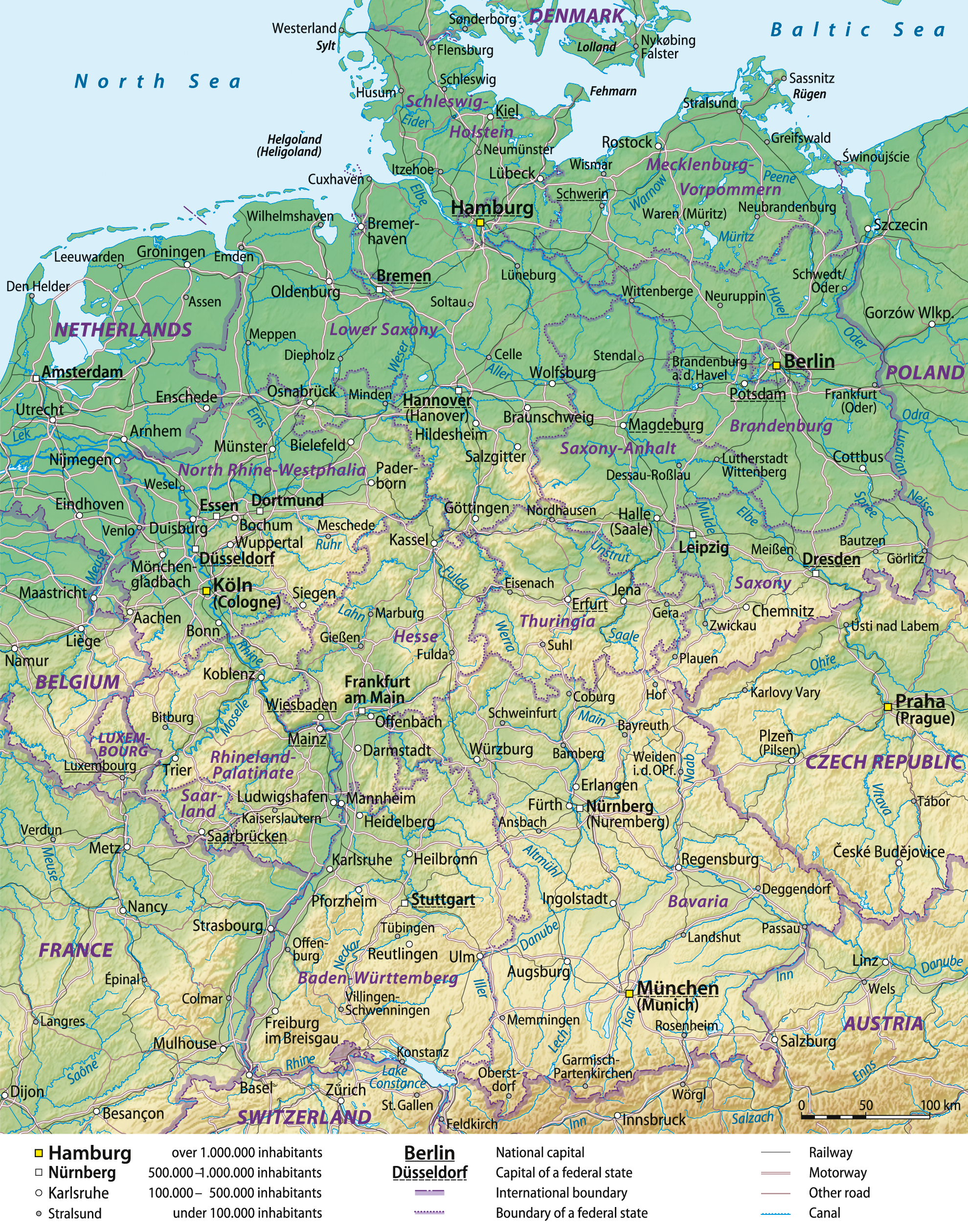
Germany general map.png - NordNordWest

EUgivetake2013.svg - AnonMoos

MKD muni nonn Rural-Urban.png - Peccafly

Languages and ethnic groups in austria3.png - Zoris Trömm~commonswiki

Austria-Hungary (ethnic).JPG - Olahus

Slovakia map rivers and cities 2008-11-17.svg - Martin Tauchman
Svpmap vaesterbotten.png - File Upload Bot (Magnus Manske)

Map of Sweden Cities (polar stereographic).png - Koyos
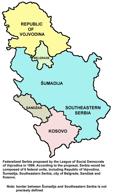
Serbia lsv.png - WikiEditor2004

Europe countries map en 2.png - Aldij

BAUDINO EUROPA 2.JPG - Familiabaudino

BAZA EUROPA.JPG - Familiabaudino

Kinks International Tour 1969.jpg - I.M.S.

Europe, EU, candidates,.png - File Upload Bot (Magnus Manske)

Germanempire 1871 english plus language.jpg - File Upload Bot (Magnus Manske)

Kinks International Tour 1969 Detail.png - I.M.S.
2008 Europe Political Map EN.jpg - Tashi-PL

Kosovo uranium NATO bombing1999.png - BorysMapping

English conquests in france 1382.jpg - File Upload Bot (Magnus Manske)

Teutonic Order 1466.png - S. Bollmann
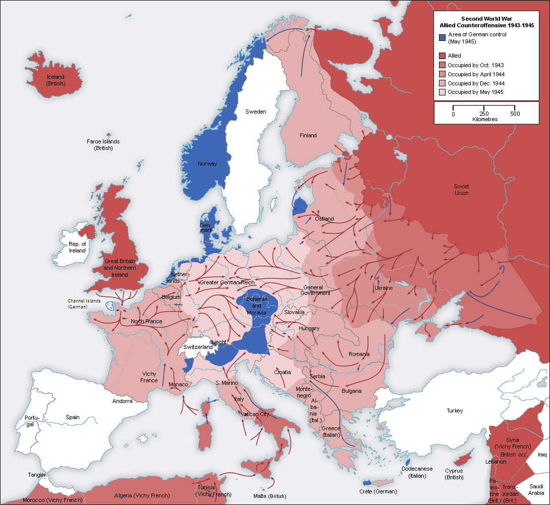
Second world war europe 1943-1945 map en.png - Rebelbear

007 Ukrainian Cossack Hetmanate and Russian Empire 1751.jpg - AlexTref871

Slovacchiait.png - Diablos86

Climates of Italy.PNG - XL3

North Sea flood of 1953.png - Kelisi

1862 Johnson Map of Spain and Portugal - Geographicus - SpainPortugal-j-62.jpg - BotMultichill

1814 Thomson Map of Greece, Turkey (in Europe) and the Balkans - Geographicus - TurkeyEurope-t-1814.jpg - BotMultichill
Europe countries map contours.xcf - Malenki

Europe countries map contours.png - Malenki
Europe countries map de contours no visa.xcf - Fixingup

Europe countries map de contours no visa.png - Malenki

1850 Mitchell Map of Greece - Geographicus - Greece-m-50.jpg - BotMultichill
1822 Butler Map of Ireland - Geographicus - Ireland-butler-1822.jpg - BotMultichill

1850 Mitchell - Cowperthwait Map of Denmark - Geographicus - Denmark-cowperthwait-1850.jpg - BotMultichill

1814 Thomson Map of the English Channel - Geographicus - BritishChannel-thomson-1814.jpg - BotMultichill

1799 Cary Map of Poland, Prussia and Lithuania - Geographicus - Poland-cary-1799.jpg - BotMultichillT

1799 Cary Map of Piedmont, Italy ( Milan, Genoa ) - Geographicus - Piedmont-cary-1799.jpg - BotMultichillT
1799 Cary Map of Mantua, Venice and Tyrol, Italy - Geographicus - Venice-cary-1799.jpg - BotMultichillT

1801 Cary Map of Austria - Geographicus - Austria-cary-1801.jpg - BotMultichillT

1799 Cary Map of Prussia and Lithuania - Geographicus - Prussia-cary-1799.jpg - BotMultichillT

1801 Cary Map of Scotland (4 Sheets) - Geographicus - Scotland-cary-1801.jpg - BotMultichillT

1801 Cary Map of Westphalia, Germany - Geographicus - Westphalia-cary-1799.jpg - BotMultichillT

1799 Cary Map of Bavaria and Salzburg, Germany ( Munich ) - Geographicus - Bavaria-cary-1799.jpg - BotMultichillT

1850 Mitchell Map of Europe - Geographicus - Europe-mitchell-1850.jpg - BotMultichillT

1853 Mitchell Map of Germany - Geographicus - Germany-mitchell-1850.jpg - BotMultichillT

1853 Mitchell Map of Austria - Geographicus - Austrai-mitchell-1853.jpg - BotMultichillT
1850 Mitchell Map of Austria, Hungary and Transylvania - Geographicus - Austria-mitchell-1850.jpg - BotMultichillT
1794 Laurie and Whittle Map of Poland and Lithuania after Second Partition - Geographicus - Poland-lauriewhittle-1794.jpg - BotMultichillT
1794 Delarochette Wall Map of the Empire of Germany - Geographicus - Germany-delarochette-1794.jpg - BotMultichillT
1794 Laurie and Whittle Map of Hungary and Transylvania - Geographicus - Hungary-lauriewhittle-1794.jpg - BotMultichillT

1818 Pinkerton Map of Ireland - Geographicus - Ireland-pinkerton-1818.jpg - BotMultichillT

1818 Pinkerton Map of Spain and Portugal - Geographicus - SpainPortugal-pinkerton-1818.jpg - BotMultichillT

1818 Pinkerton Map of Poland - Geographicus - Poland-pinkerton-1818.jpg - BotMultichillT

1818 Pinkerton Map of the British Isles (England, Scotland, Ireland) - Geographicus - BritishIsles-pinkerton-1818.jpg - BotMultichillT

1818 Pinkerton Map of Beligum - Geographicus - Belgium-pinkerton-1818.jpg - BotMultichillT
1818 Pinkerton Map of Holland or the Netherlands - Geographicus - Holland-pinkerton-1818.jpg - BotMultichillT

1818 Pinkerton Map of Russia in Europe - Geographicus - RussiaEurope-pinkerton-1818.jpg - BotMultichillT

1818 Pinkerton Map of the Austrian Empire - Geographicus - Austria-pinkerton-1818.jpg - BotMultichillT

1794 D'Anville Two Panel Wall Map of Europe - Geographicus - Europe-anville-1794.jpg - BotMultichillT

1794 Laurie and Whittle Map of Switzerland - Geographicus - Switzerland-lauriewhittle-1794.jpg - BotMultichillT

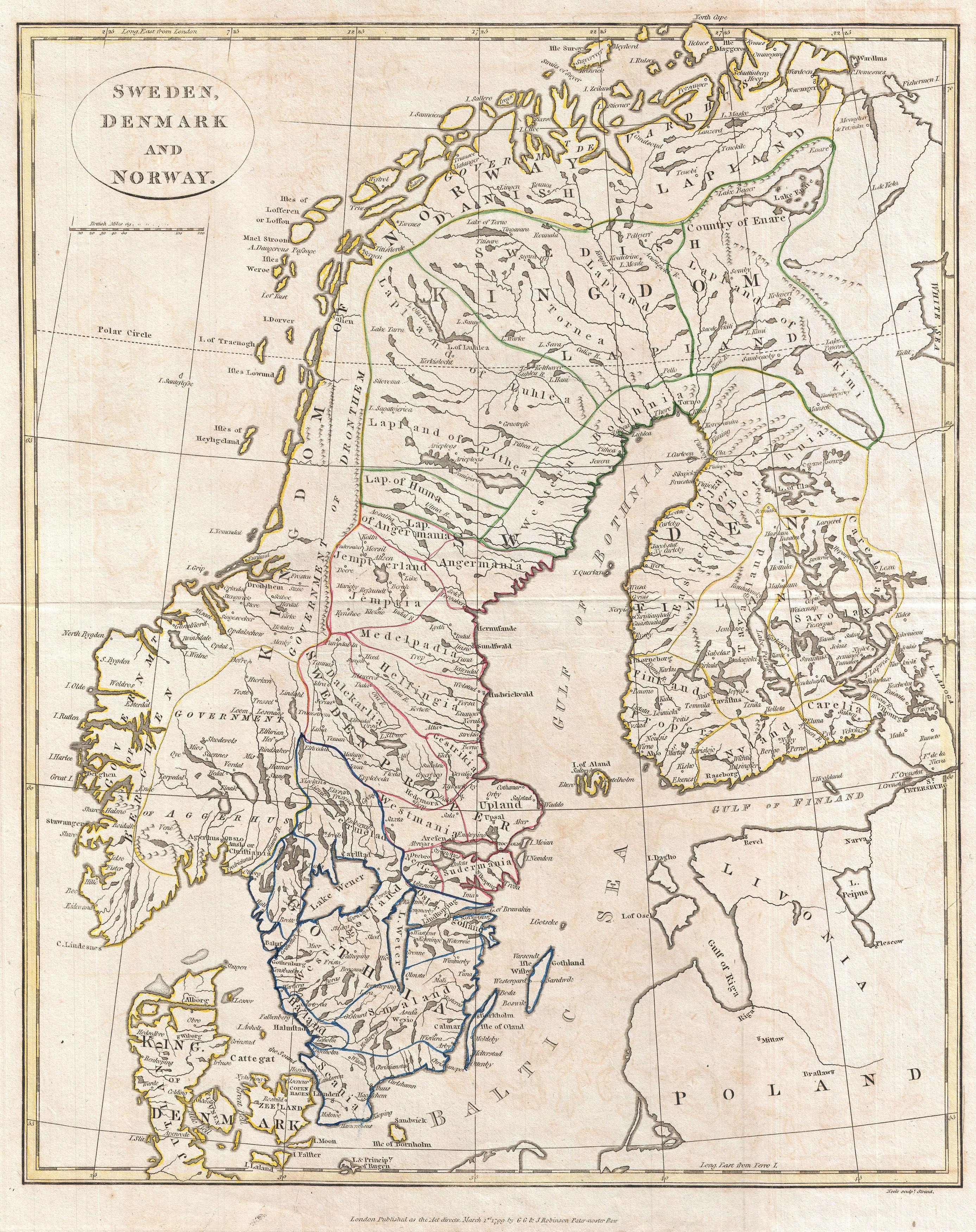
1794 Laurie and Whittle Map of Norway, Sweden, Denmark and Finland - Geographicus - Scandinavia-lauriewhittle-1794.jpg - BotMultichillT
1794 Laurie and Whittle Map of Holland or The Netherlands - Geographicus - Holland-lauriewhittle-1794.jpg - BotMultichillT

1794 Laurie and Whittle Map of Belgium - Geographicus - Belgium-lauriewhittle-1794.jpg - BotMultichillT
1794 Anville Map of England in ancient Roman times. - Geographicus - England-horsley-1794.jpg - BotMultichillT

1794 Anville Map of Europe in late Roman times - Geographicus - WesternEurope-anville-1794.jpg - BotMultichillT

1794 Campbell Map of Scotland - Geographicus - Scotland-campbell-1794.jpg - BotMultichillT

1850 Mitchell Map of Scandinavia, Norway, Sweden, Denmark, Finland - Geographicus - NorwaySweden2-mitchell-1850.jpg - BotMultichillT

1799 Clement Cruttwell Map of Europe - Geographicus - Europe-cruttwell-1799.jpg - BotMultichillT

1799 Clement Cruttwell Map of Ireland - Geographicus - Ireland-cruttwell-1799.jpg - BotMultichillT
1799 Clement Cruttwell Map of Scotland - Geographicus - Scotland-cruttwell-1799.jpg - BotMultichillT

1799 Clement Cruttwell Map of Spain and Portugal - Geographicus - Spain-cruttwell-1799.jpg - BotMultichillT
1799 Clement Cruttwell Map of Sweden, Denmark and Norway - Geographicus - Scandanavia-cruttwell-1799.jpg - BotMultichillT
1799 Clement Cruttwell Map of France in Provinces - Geographicus - FranceProvinces-cruttwell-1799.jpg - BotMultichillT

1799 Clement Cruttwell Map of France in Departments - Geographicus - FranceDepartments-cruttwell-1799.jpg - BotMultichillT

1799 Celement Cruttwell Map of Germany - Geographicus - GermanySwitzerland-cruttwell-1799.jpg - BotMultichillT

1799 Clement Cruttwell Map of Italy - Geographicus - Italy-cruttwell-1799.jpg - BotMultichillT

1814 Thomson Map of Tuscany (Florence), Italy - Geographicus - Tuscany-t-1814.jpg - BotMultichillT

1796 Cary Folding Case Map of England ^ Wales - Geographicus - EnglandWales-cary-1793.jpg - BotMultichillT

1809 Pinkerton Map of Northern Italy ( Tuscany, Florence, Venice, Milan ) - Geographicus - ItalyNorth-pinkerton-1809.jpg - BotMultichillT

1830 Pigot Pocket Map of England and Wales - Geographicus - EnglandWales-pigot-1830.jpg - BotMultichillT

1840 Lizars Map of Scandinavia ( Norway, Sweden, Finland, Denmark, Iceland ) - Geographicus - Scandinavia-lizar-1840.jpg - BotMultichillT
1814 Thomson Map of Bavaria, Germany - Geographicus - Bavaria-t-1814.jpg - BotMultichillT

1815 Thomson Map of Spain and Portugal - Geographicus - Spain-t-15.jpg - BotMultichillT

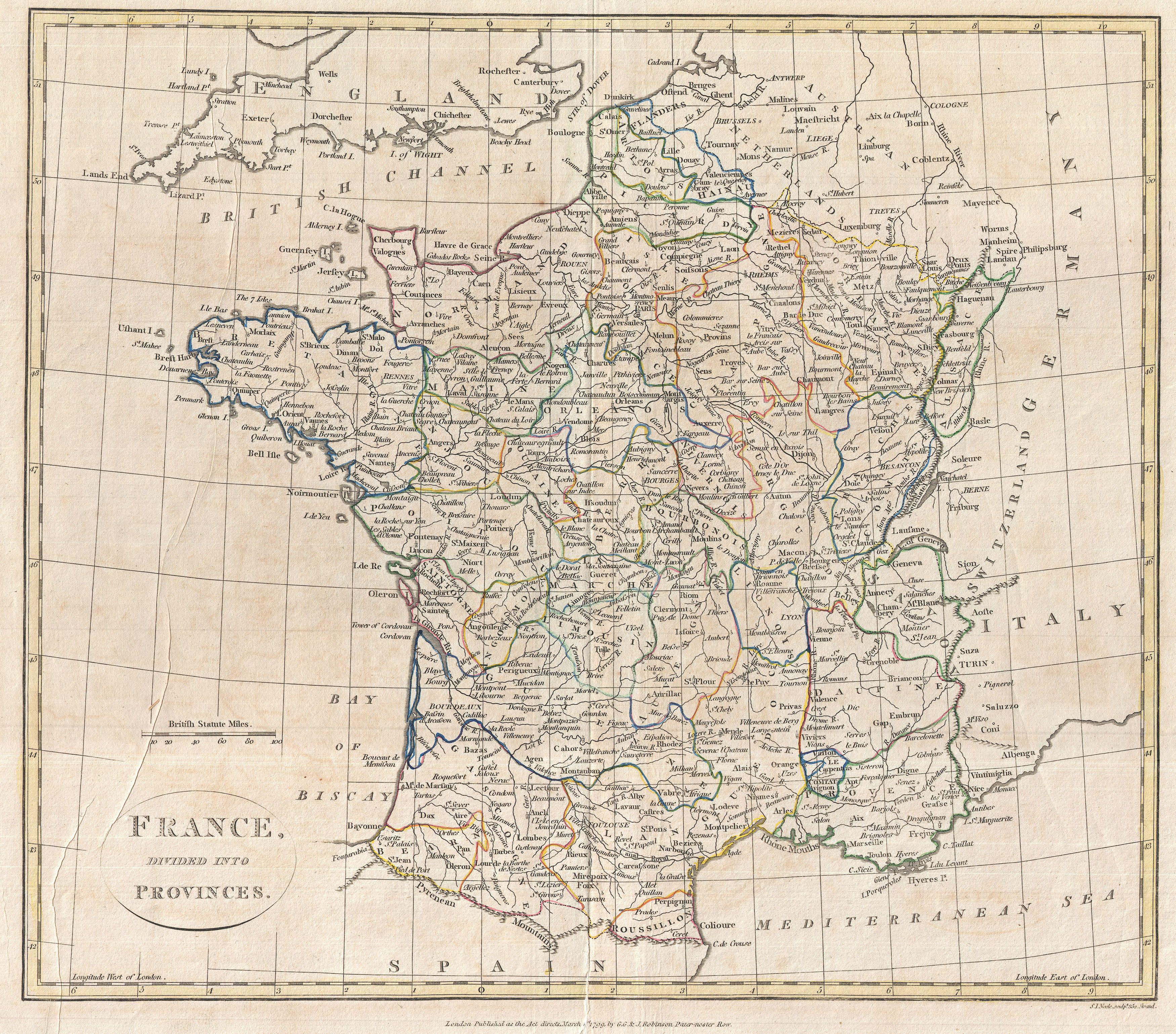
1814 Thomson Map of France - Geographicus - France-t-1814.jpg - BotMultichillT

1850 Mitchell and Cowperthwait Map of Ireland - Geographicus - Ireland-m-1850.jpg - BotMultichillT

1851 Black Map of Norway and Sweden (Scandinavia) - Geographicus - NorwaySweden-black-51.jpg - BotMultichillT

Europe countries map ee.png - Jesswest

Map- France at the Treaty of Bretigny.jpg - Soerfm
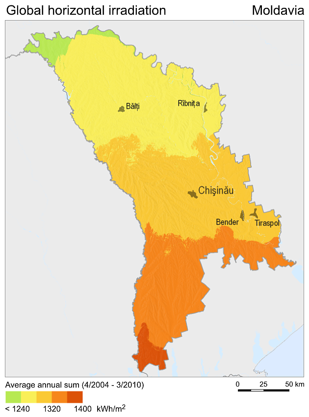
SolarGIS-Solar-map-Moldavia-en.png - Octavix

SolarGIS-Solar-map-Europe-en.png - Ayane m

SolarGIS-Solar-map-Denmark-en.png - Rfassbind

France GHI Solar-resource-map GlobalSolarAtlas World-Bank-Esmap-Solargis.png - SolarSoft

SolarGIS-Solar-map-Switzerland-en.png - SolarSoft

1799 Cary Map of Tyrol - Geographicus - Venice-cary-1799.jpg - Gryffindor
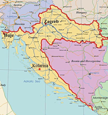
Karta hrvatska.jpg - Arabadaram
1968legifr.png - File Upload Bot (Magnus Manske)
Partition of Ottoman Empire (Anatolia).png - Moodylo333

UEFA Euro 2012 en better.jpg - Ottobdn

Paleo-Balkan languages in Eastern Europe between 5th and 1st century BC.png - Stevan22

Ethnic Pakistanis in Britain.png - Elraja1988

Poland airports 2011plusUnderConstruction.png - PLKristof

Cassubia1238 Kaszubi na Pomorzu.png - Cassubia1238

Cassubia1238 Język Kaszubski 2002.png - Cassubia1238

Cassubia1238 Narodowość Kaszubska 2002.png - Cassubia1238

UEFA members.svg - MacedonianBoy

Pvgis solar horiz CZ.png - Rillke
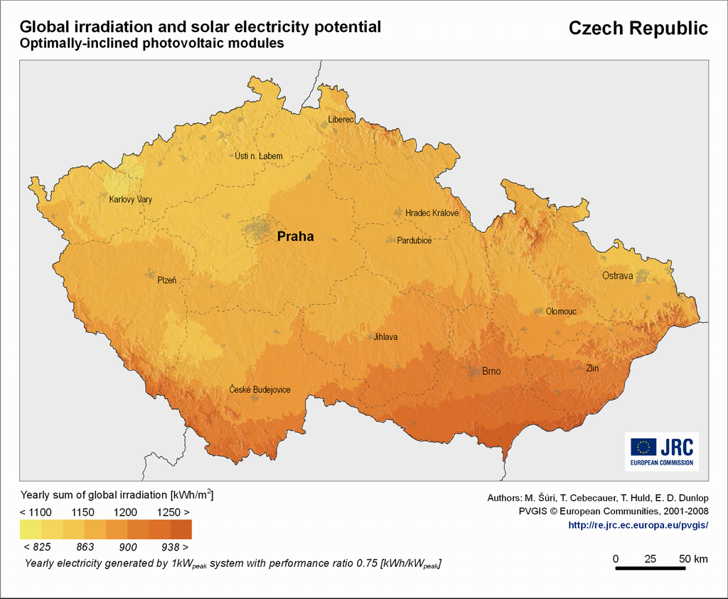
Pvgis solar optimum CZ.png - Rillke

Kataja-en.svg - Samoasambia
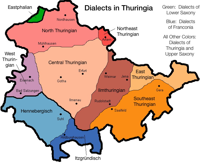
Thuringian Dialects EN.jpg - Brokal

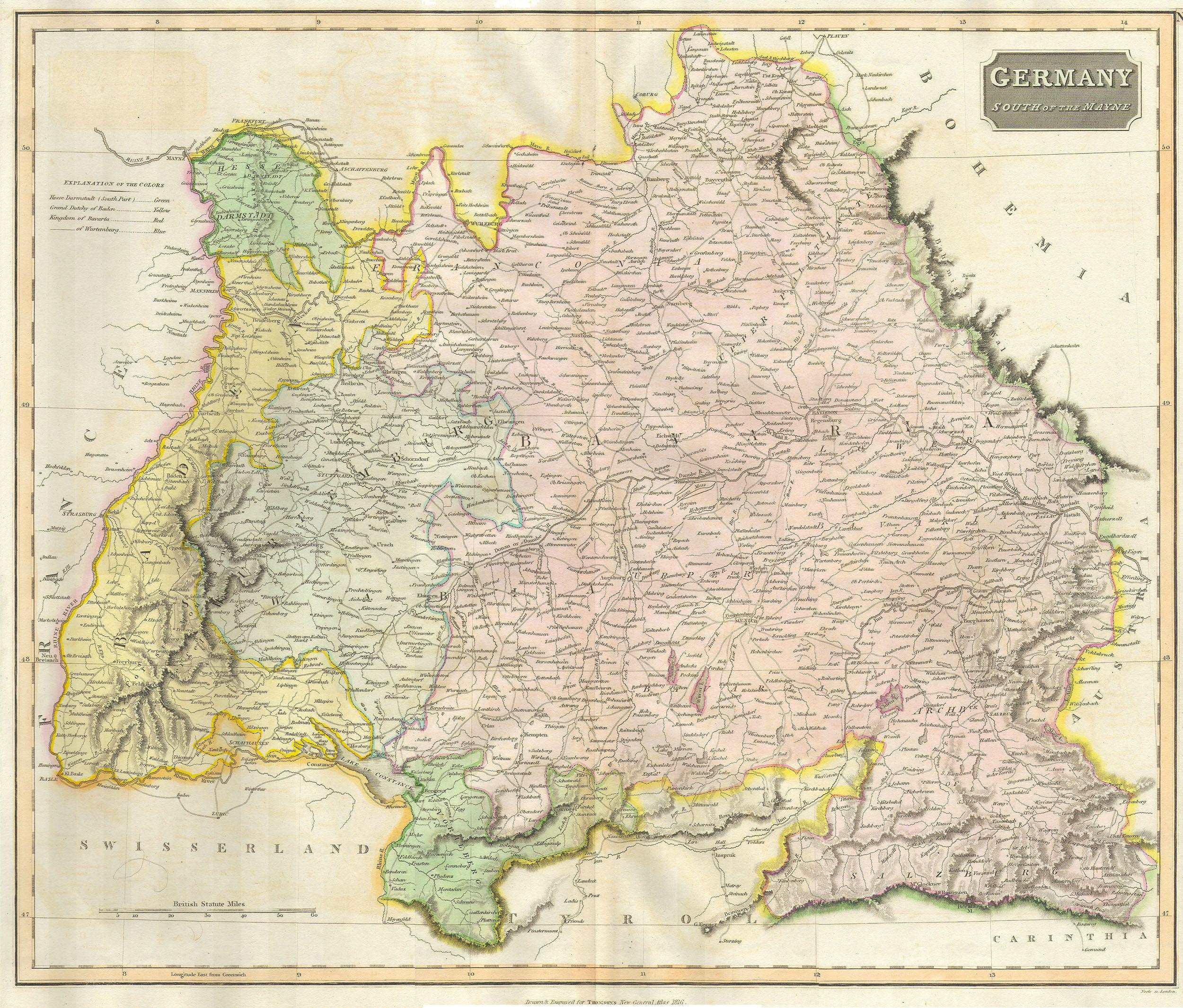
Germany general map.jpg - Adam Cuerden

Kashubian language and nationality.png - Cassubia1238
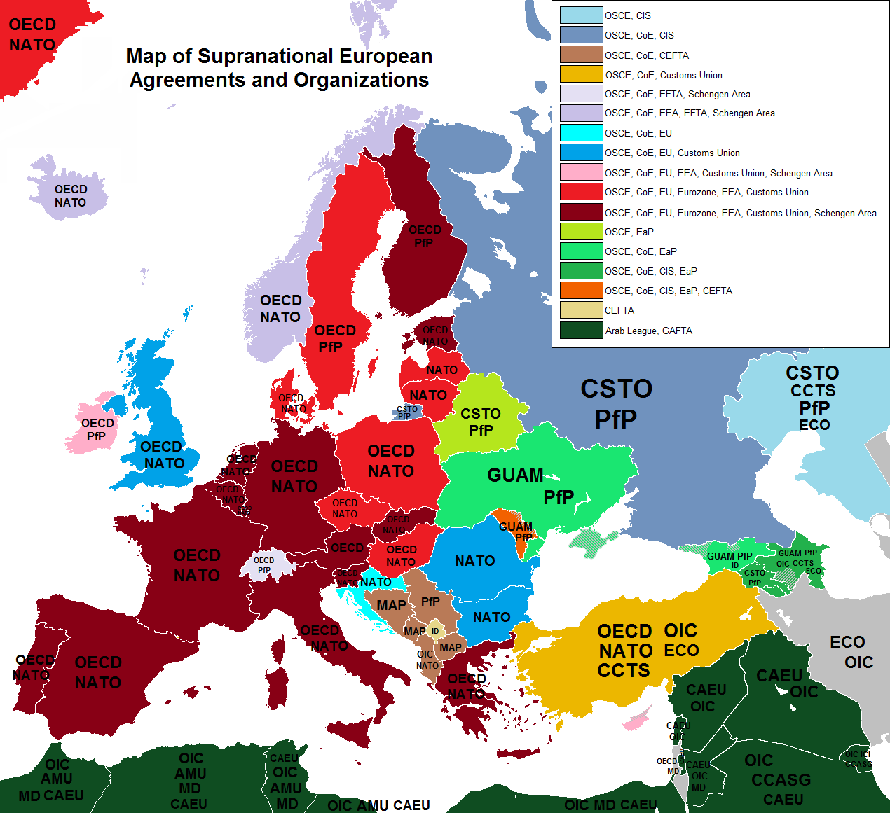
Alliances of europe.png - Iktsokh

AEF Stations France 1918.jpg - Bwmoll3

Poland airports 2012.png - Lapeno
Krain ETHNIC 1910 Pict 1.JPG - IlirikIlirik

BASA-176K-2-804-87-Etnographical map of the Southern Slavs, 1913.JPG - BASA Спасимир

Polesia map - topography.jpg - Moodylo333

Countries of Europe last subordination png.png - Bepoyo

Map of the Energy Community Members.jpg - Anon126

Angling in troubled waters – a serio-comic map of Europe - Kungliga Biblioteket - 2818247-thumb.png - L PBot

오스만 제국의 분할 지도 (소아시아 반도).png - 고려

Sardinia Köppen.svg - Redtitan

Regional vote IT 1970.png - FastilyClone

Angling in troubled waters = der fischfang im truben = la peche en eau trouble = la pesca nelle acque turbes - a serio-comic map of Europe (14028135563).jpg - Fæ

Catalonia. 1862 Johnson Map of Spain and Portugal - Geographicus - SpainPortugal-j-62 (cropped).jpg - Geagea

Iberia 300BC-pt.svg - Renato de Carvalho Ferreira

127 of '(Physiography- an introduction to the study of nature ... With illustrations and coloured plates.)' (11268926146).jpg - Artix Kreiger 2

Fred W Rose Angling in troubled waters.jpg - Anvilaquarius

Hu-map Modifiziert Route.png - Thirunavukkarasye-Raveendran

Atlas and plat book of Guthrie County, Iowa - containing outline map of the county, plats of all the townships with owners' names, plats of cities and villages, also state map, United States map, LOC 2008629002-34.jpg - Fæ

Angling in Troubled Waters A Serio-Comic Map of Europe.jpg - Balkanique

European countries by forest cover.jpg - Radom1967

Caricature map 1914--1915--1916--1917--??.jpg - Balkanique

The illustration of the Great European War. No. 16.jpg - Balkanique

Estimated Port Capacities in Europe as of 1943.jpg - Balkanique

Vexilographic maps of Pontic littoral by end of 13th-17th century.svg - Niklitov
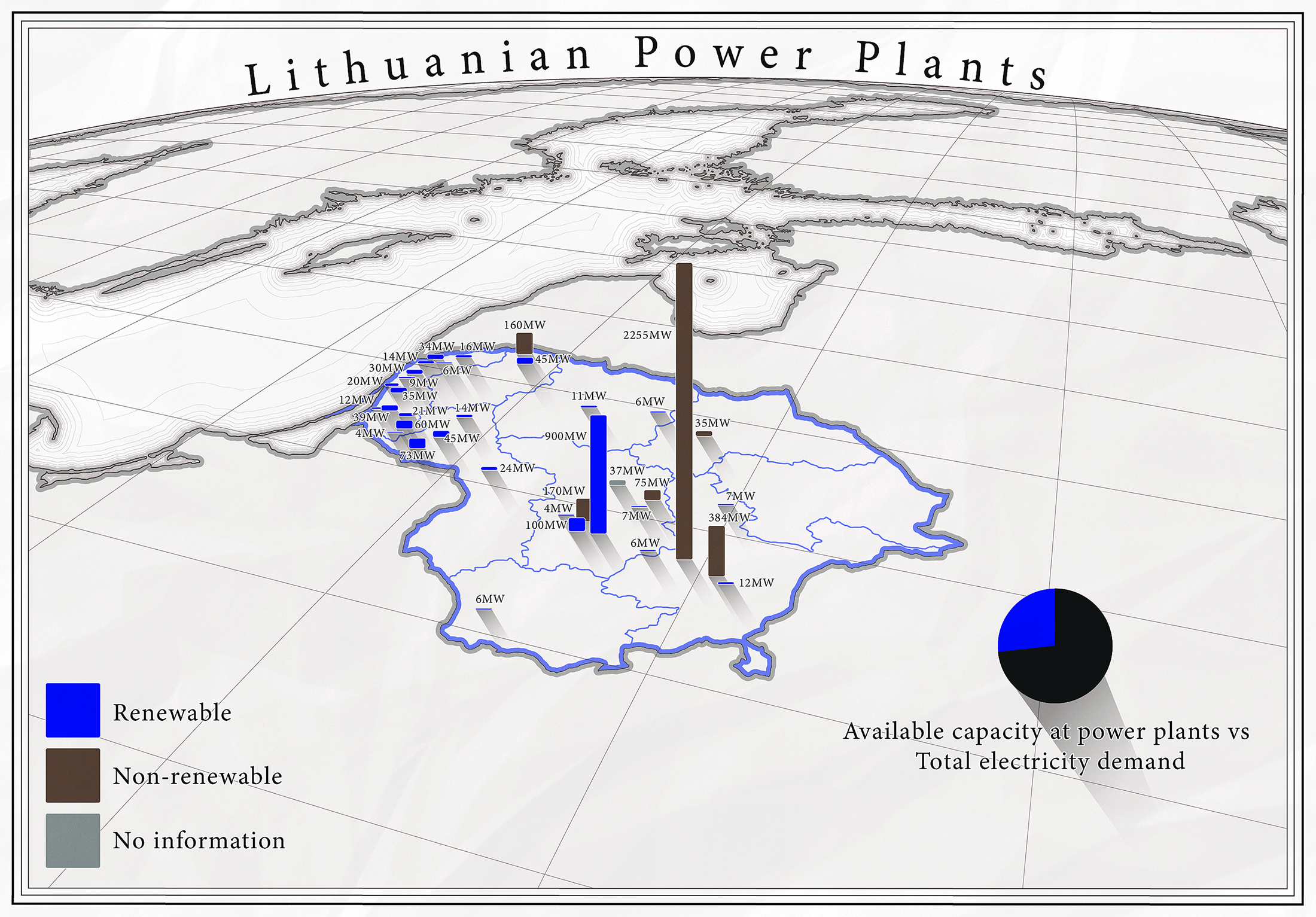
Lithuanian Power Plants.png - Pavelzuk
Carolingian empire 863.pdf - Gellie09
1899 satirical map of Europe - Angling in troubled waters - by Fred W. rose.tiff - Balkanique

Map- France at the Treaty of Bretigny (cropped).jpg - Gog the Mild

Map of European states and nationalities in 1917.jpg - Jan.Kamenicek

Median wealth per adult in Europe (2019).png - Iktsokh

Map showing the location of the Micoquian (red circle) and Levallois-Mousterian (blue circle) sites in Europe during MIS 5c—5a and Stajnia Cave.webp - Prototyperspective

John Cary 1799 map of the territory of Bergamo.jpg - Dans

Map of human fossils with an age of at least ~40,000 years that yielded genome-wide data and location of the Zlatý kůň fossil.webp - Prototyperspective

Geographical distribution of Neanderthal archaeological sites and genome-wide distribution of Neanderthal alleles in the genomes of ancient modern humans.webp - Prototyperspective
Angling in troubled waters- a serio-comic map of Europe. (IA bp 14539).pdf - Fæ

Saimaakanal-en.svg - Akeosnhaoe

Europe Iron ore reserves - Departement of state, map division - btv1b53196975w.jpg - Gzen92Bot

East Central Europe de facto and treaty boundaries september 1944 through february 1947 and current zones of occupation - Department of State, Map Division - btv1b53196979p.jpg - Gzen92Bot

Proportion of working population in industry, ca. 1930 - Europe, excluding U.S.S.R. - Division of map intelligence and cartography - btv1b53196976b.jpg - Gzen92Bot

Lithuanian (1850).jpg - Kazimier Lachnovič
ECDM 20220930 DM CoronaVirusOutbreak EEAS Europa.pdf - Lupe

Selected Emigration Trends, Immigration into the United States from Europe, 1820-1924 - DPLA - 82604788ca50ffb087a891dd30bac256.jpg - DPLA bot

South Central Europe Physiographic Diagram - DPLA - 7c59218119f037a64bc468a87db23e4d.jpg - DPLA bot

Danube River Basin Boundaries - DPLA - 7faf360017077c7d8baba44e6cc73335.jpg - DPLA bot

Yugoslavia Railroads - DPLA - d05b596972175aa133404ddda3c281da.jpg - DPLA bot

Samuel John Neele, Ancient Europe (FL33132557 2521729).jpg - Geagea
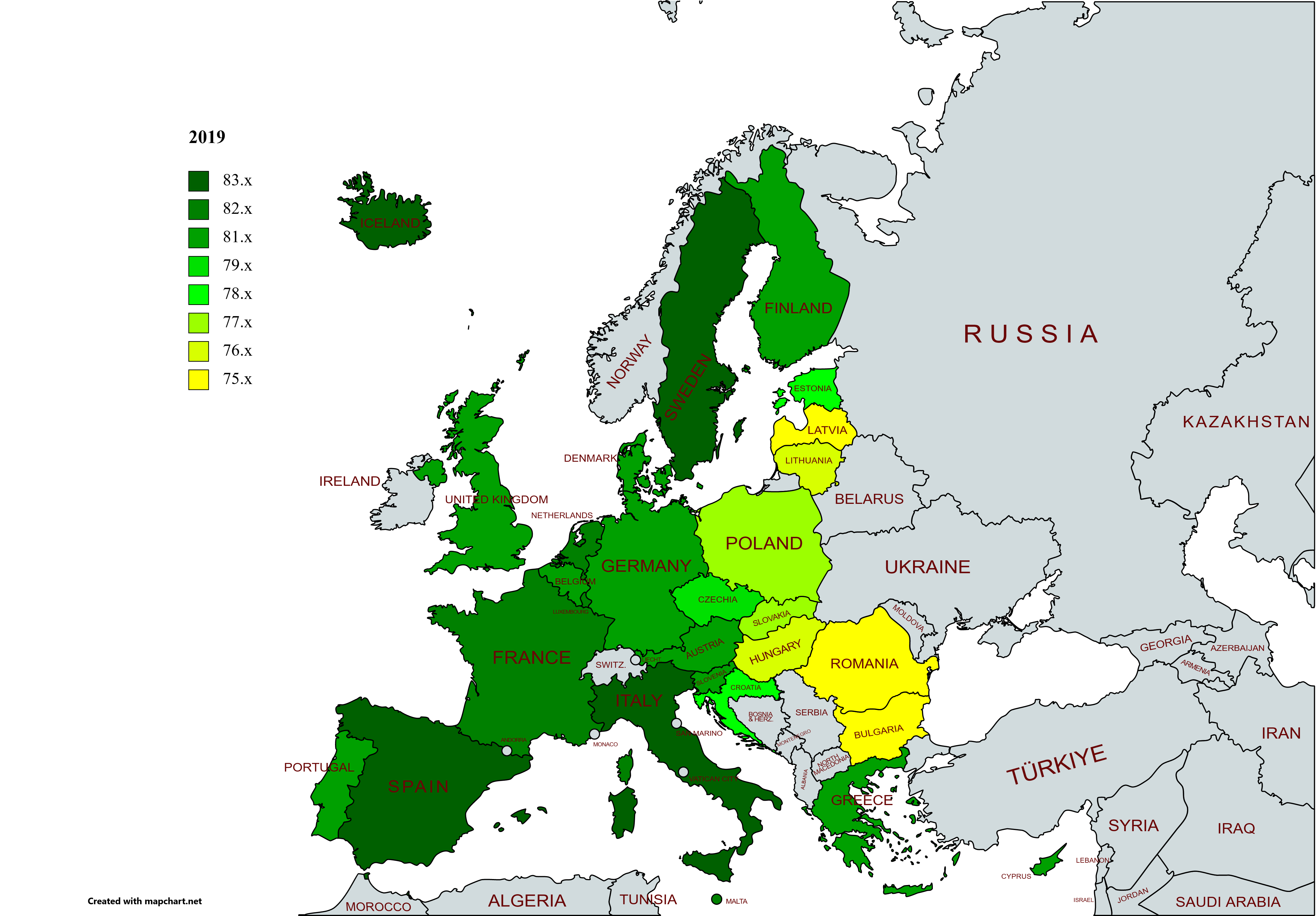
Life expectancy map -EU -2019 -with names.png - Lady3mlnm
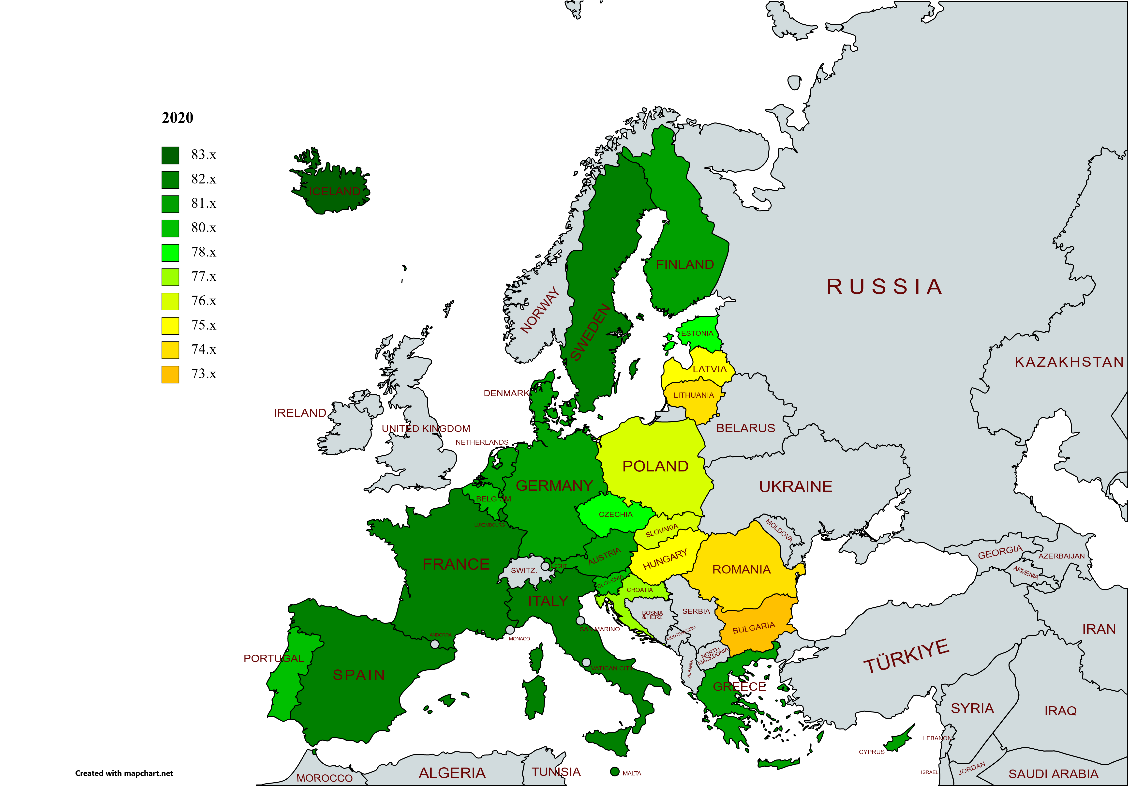
Life expectancy map -EU -2020 -with names.png - Lady3mlnm

Life expectancy map -EU -2021 -with names.png - Lady3mlnm

Life expectancy map -Europe -2019 -with names.png - Lady3mlnm

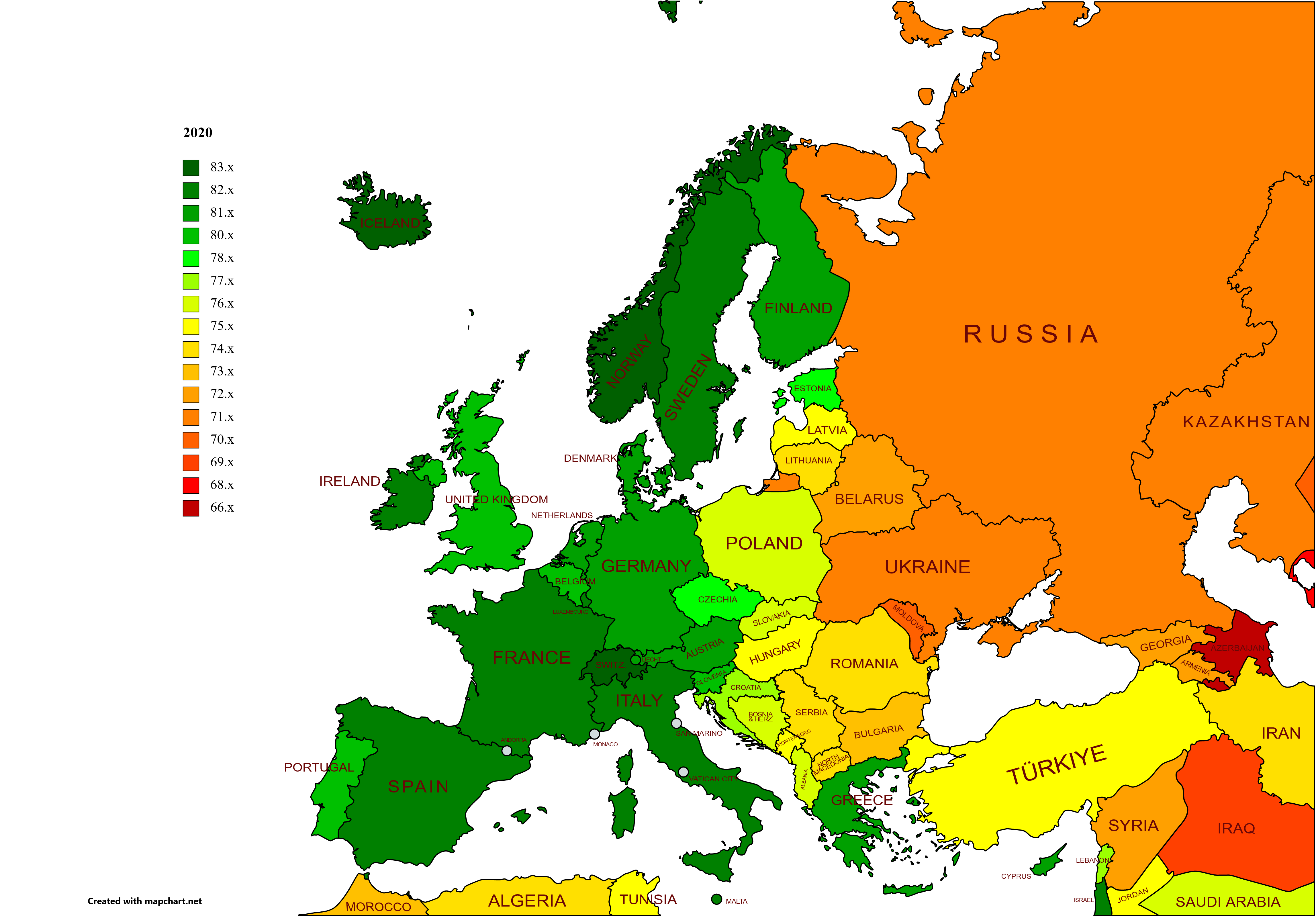
Life expectancy map -Europe -2020 -with names.png - Lady3mlnm

Life expectancy map -Europe -2021 -with names.png - Lady3mlnm

Life expectancy map -Europe exp -2019 -with names.png - Lady3mlnm
Life expectancy map -Europe exp -2020 -with names.png - Lady3mlnm

Life expectancy map -Europe exp -2021 -with names.png - Lady3mlnm

Map of Europe (FL50811024 3718103).jpg - Geagea

Europe rail electrification en.svg - Xolani